The presence of the Antarctic continent on the Piri-reis map is in debate, with suggestions that the bottom tip of the south American continent was simply ‘squeezed’ on, following a miss-judgment in size by Piri-reis. Regardless of this, there are other ancient maps which clearly do have the outline of the continent on them, with both Gerard Mercator's map of 1569 AD
and the Oronteus Finaeus map of 1532 AD (right), also showing the coastline, and the Hadji Ahmed map of 1559 AD, which not only has Antarctica with a correct Mercatorial projection but also shows a land bridge between the Bering straits, re-enforcing the suggestion of an antiquitous origin. The specific division of the Antarctic continent into two smaller land-masses on these ancient maps is similarly a mystery as it was only at the end of the 20th century that we were finally able to determine (through satellite technology) the accurate outline of the Antarctic continent, which was found to be identical to those seen on some of the oldest surviving maps of the world.
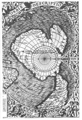
ORONTEUS MAP
