"Re Read something on twitter about the Q watch times and how they are latitudes and longitudes for trafficking hives." (Lives?) ~~~~~~~~~~
That's a new one to me -- but, (within the accuracy limitation of readable watch digits) it sounds feasible for specifying a location within a few miles of a target...
Hmmm... When you include the full DTG ("Date-Time Group") there are more digits (decimal places) for improved accuracy...
Let me get a BIG LSJI-OHI-HTML-Graphics page finished re something bitt posted --- and, I'll "hurt mah haid" on what the range of coordinate possibilities are -- within the full DTG range of numbers...
ThanQ for the "heads Up!"
TXnMA

P.S. ThanQ, MQD, for the new thread! I guess this makes me "IN" on it... '-)
bitt, et al: here's my long-promised reaction to bitt's
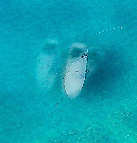
"Ghislane's Submarine?" grab from Twitter.
As you'll see, I used the opportunity to lecture on the weaknesses of Apple Maps, to create yet another page for my (unreleased) "Epstein's Properties" website - and had a little debunking fun...
Enjoy!'-)
TXnMA
Was Ghislane Maxwell's (or Branson's) Submarine at
Epstein's "LSJI" (Little St. James Island)?
(This analysis/tutorial is part of an ongoing effort -- applying "OHI" (OverHead Imagery) analysis techniques to open-source imagery -- to evaluate what may have transpired on Jeffery Epstein's "LSJI" [aka "Pedpophile Island"].)
Ghislane Maxwell has been reported to have a pilot's license for "small, submersible craft" -- but, is there evidence that she piloted some sort of submarine (loaded with "clandestine" passengers) -- to LSJI?
FReeper/FReeQ, bitt, posted this from Twitter -- on a FRee Republic "Q" thread:

Here's the answer to the "Why 2013? question:
The bottom two images are "screen grabs" from Apple Maps. Apple's mapping aircraft made its photo flights over LSJI in 2013.
The fact that the bottom two image(s) image were "grabbed" from "Apple Maps" also explains the purported "submarine" image(s) alongside the LSJI dock:
The explanation lies in how Apple Maps creates those strikingly-good "3-D" photographic maps -- that can be viewed from any direction and at a wide range of angles:
- Apple's mapping plane makes multiple, overlapping (GPS-guided) parallel "passes" back & forth over a large area -- as if it were "mowing a lawn".
- Apple's mapping software then matches up images from multiple passes, overlaying & "stitching" them together into a single database for 3-D viewing.
- The overflight area may be so large (and take so long to shoot one "strip") that one pass over a specific point (i.e. a docked or anchored boat) may be made while the ocean surface is at low tide level, with a final pass occurring at high tide.
The images in this 2013 overflight are composites of images from three (3) overflight "passes".
- That means that a single boat could have been "shot" while floating at three different "Z-axis" elevations (water levels) and/or three different X-Y positions.
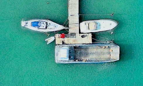
When I was working on OHI analysis of LSJI's "South" point (with the gold-domed, striped, "Satanic Temple") I noticed that just off the west side of the point is a popular fishing and diving area. In fact, -- on Google Earth -- one particular white, aft-cockpit boat shows up there repeatedly over a span of several years. The owner apparently spent lots of time snorkling or SCUBA diving in the vicinity.
But the "Apple Maps" image of that boat really made me question what was going on:
The answer turned out to be (relatively) simple:
- The boat was moored to a buoy off its stern and anchored off its bow, and was "swinging" as the wind changed. The same boat was photographed in three different X-Y positions.
- The three overflight images were made when the tidal water depth was at three different levels:
- The right-most ("under" the visible boat} position was near low tide.
- The left-most position was at some middle elevation (water depth).
- The center position was near -- but not quite at -- high tide elevation.
- The last thing the mapping software does --after compositing the three image sets -- is to "drape" or "paint in" the water surface texture and color -- at approximate high tide level.
- Boat images below the painted/draped (high tide) water level -- are over-painted-- as if they are underwater.
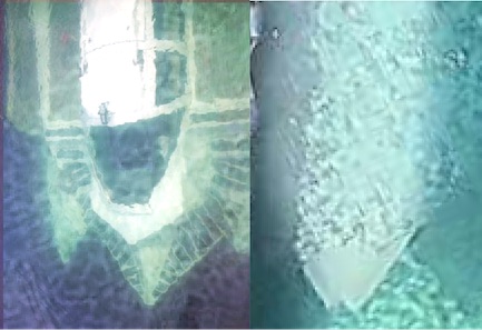
Upon close inspection, the lower photos in the published composite are almost self-debunking:
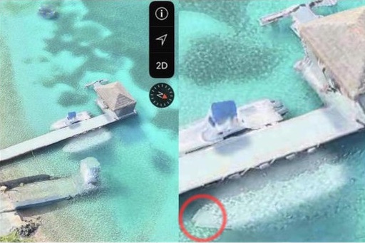
Note the area circled in red. The "submerged" boat appears to have two prows -- indicating that it was photographed at two different below-high tide water levels, and in two slightly-offset X-Y positions.
Same scene; two other views from slightly different headings in the same Apple Maps database...
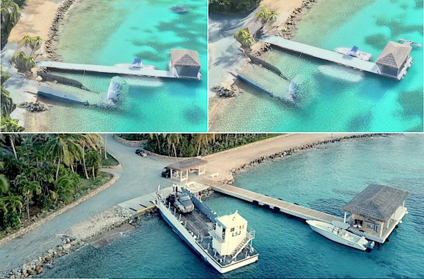
...compared with a ?drone? photo of Epstein's "LSJ" landing/equipment transport craft -- "beached" on the wharf at high tide. Note the high pilot house and the continuous gunwales...
In the Apple Maps view at upper left, notice that the water is at the high tide mark, but the angle of "LSJ", the landing craft, indicates that it is apparently "grounded" on the bottom at ~low tide.
The photo at upper right -- "clipped from" a more southerly Apple Maps viewing angle -- shows that the software "attempted to" depict the tall pilot house as underwater (an impossibility at that shallow depth). And all three Apple Maps views show interruption of the landing craft's gunwales as partially missing.
- The Landing craft was photographed at low tide -- as was the white boat.
- As soon as the stern of the Landing craft was afloat, it departed -- and was not at LSJI in the two subsequent photos. In fact, when the "High Tide" Apple Maps photo was made...
..."LSJ"was moored at a dock in Epstein's marina in Vessup Cove on St. Thomas Island -- some 2.3 air miles from the LSJI dock!
- After the Landing craft departed, the white boat was photographed a second time (at some "middle" water level).
- Then, (unlike the boat on the opposite side of the pier) before the third (high tide) Apple Maps photo was made, the white boat departed LSJI.
- Finally, in the third, (high tide) photo, only the boat docked at the far side of the pier was photographed.
BOTTOM LINE: Neither the "LSJ" Landing Craft nor the white "submerged" boat was present at LSJI when the photo posted on Twitter was taken.
There was no "submerged" vessel at the LSJI dock -- period.
Tutorial remarks...
While Apple Maps proves useful for providing photographic views of sites like LSJI for intel purposes, Apple Maps is primarily a road-navigation tool. Expecting it to deal accurately with an ever-changing ocean environment is beyond its scope.
If You Want to Try OHI Intel Research...
- Question Everything.
- Know your tools (Google Earth/Maps, Apple Maps, etc.) -- especially their weaknesses.
(A Google Earth weakness is explored here: "Warped Tennis Courts"...) - Learn to measure -- accurately!
- Learn to integrate over time...
- Learn that satellites don't always pass directly over your "AOI".
- Don't believe your lying eyes!
- Question Everything!
"And, now, the Rest of the Story"
None of the above analysis / tutorial was required -- to debunk the Twitter post.
When submerged, the Marion "HyperSub" depicted in the top photo bears zero resemblance to the featureless white "submerged" boat. That fact, alone, suffices to debunk the entire baseless speculation:

For Those with Agendas -- Pushing "Truther" Conspiracy Theories...
- Make sure the "evidence" you're using actually exists.
- When you "Connect the Dots": Make sure the "dots" have some sort of actual relationship to each other.
- Don't "cherry-pick" by ignoring evidence that doesn't "fit" your 'theory'.
- Find an honest way to waste everyone's time...
TXnMA