Posted on 07/01/2021 11:16:41 AM PDT by Red Badger
PinGGGY!.......................
Great read thanks maybe the 4th will have an epic finale
Cool stuff.
An impact like that would melt the glaciers really, really fast. And it would have literally scraped the face of the earth down to bedrock. If it hit in North America, this would explain the erosion in the south west.
And it explains “The Flood.” Doesn’t change the biblical narrative at all.
Imaginative fellow.
“Pillar 2: The second central pillar of Enclosure A, likely depicts the sequence of constellations, Capricornus (bull), Aquarius (fox) and Pisces (tall bending bird), which would likely have been the path of the radiant of the northern Taurid meteor stream circa 10,000 BC. Possibly, this pillar represents the name of that meteor stream.
“We know the Taurids exhibit longitudinal precession of roughly 30 degrees every 6,000 years, which equates to about 4 hours along the ecliptic from today’s radiant path if translating to 10,000 BC). This means the current path of the Northern Taurids shown in Stellarium (mid-Pisces through Aries to the end of Taurus) would translate to mid-Capricornus through northern Aquarius to end-Pisces, as shown on Pillar 2. The fox, though, is facing the wrong way, so I have reversed Aquarius in the image below.
“Similarities with the Cartouche writing convention of AE is clear - see an example in the middle below. See also a stone plaquette (below right) found at GT, which has a similar structure. Possibly, this stone plaquette tells the story of the comet god (trident symbol) who attacked and killed (explosion symbol) the cosmic serpent god (falling snake symbol) who fell to Earth, perhaps a mythical description of the Younger Dryas event. It is a myth, the ‘chaoskampf’, repeated in many religions, including by the Ancient Egyptians (Set vs Apep), Babylonians (Marduk vs Tiamat), and Christians (the fall of Satan). The site’s archaeologists interpret this stone plaquette simply as the sequence (the other way up), snake, tree, bird, with no further meaning.
“The bull symbol at the top of Pillar 2, likely representing the constellation Capricornus, is probably connected to many ancient cow deities and entities, including those of Ancient Egypt (e.g. Hathor and Apis) and the Babylonian Bull of Heaven, and even the Pictish Burghead Bull symbols. Typically, the bull is associated with death, an association that might date back to the the Lascaux Shaft Scene and a time when the Taurid meteor stream was probably centred on Capricornus.”
https://martinsweatman.blogspot.com/2020/10/gobekli-tepes-pillars.html
It would explain the Grand Canyon...................
No, only the Noachic flood explains the grand canyon, the state of florida, the immense sand deposit in the gulf of mexico, etc. The great flood is no myth, it is geologic fact that we see every day.
Something like trillions and trillions of gallons of water carved out the Grand Canyon, and very quickly.
A a flood of melting ice sheet from a comet impact would fit the bill...............
Depends on the direction and angle the comet hit and the wind patterns.........................
Hence the ferocity of the Science dogma about any YD event discusssion. Not permissible since the implications are not permissible.
In ancient cultures, the bird symbol usually represents the Swan, not Pisces. The Swan was the representation of birth, life, and death to the ancients prior to the Event and afterward.
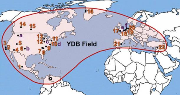
Examples of the Events ferocity can be seen in the Carolina Bays and the Nebraska Rainwater Basin this were likely created by thrown off impact debris which in this case would be huge sheets of Ice from the Glacial impact - while the Author cites Greenland as a possible impact site, there exists good evidence that not only were there multiple impacts by 1 mile diameter rocks, but that tracing the possible impact trajectory back to somewhere in the Great Lakes-Northern Michigan area. Numerous authors believe that the strikes lasted about 100 years, turning plants, animals, people into slices from the ice shards impacting the earth and shattering, while other strikes caused fires - not just forest fires, but firestorms lasting decades.
One notable fact is that before the strikes, North Africa was a lush forested land; but after it became dry, hot and harsh. Many people were forced to move west to the Nile valley. This was a real climate change, not the pseudo-scientific one claimed by leftards today.
I always thought that it was too “sharp” to have been eroded over millions of years. But that isn’t a scientific theory…HA HA.
The “flood mythology” is not unique to the Bible. I’m not sure why people (on either side) get worked up over that.
are there not prevailing westerlies? i am confused...

No not the Grand Canyon that is attributable to other things. The rest has some validity - there certainly were floods as sea level rose on average 450 feet worldwide, and in some places 750 feet, covering millions of square miles of once prime habitable land and river mouths.
I’m no geologist, but I play one on FR......................
Washington state scablandss too. https://www.pbs.org/wgbh/nova/megaflood/about.html
TV Program Description
Original PBS Broadcast Date: September 20, 2005
Mystery of the Megaflood homepage
One of the Earth’s strangest geological riddles is the evidence for a huge catastrophe that struck eastern Washington State thousands of years ago. It took scientists decades to figure out that a colossal flood had carved out bizarre landscape features strewn across thousands of square miles. On “Mystery of the Megaflood,” NOVA gets to the bottom of what created this compelling detective story.
“Mystery of the Megaflood” features a dogged geologist sticking to his bold theory for decades despite virtual professional banishment. Eventually, other geologists joined his cause and filled in the intricate details, which NOVA recreates in stunning computer animation to show what may be one of the most spectacular series of events ever to occur on our planet.
The so-called “scablands” are a vast region of weird terrain 200 miles east of Seattle, including gorges hundreds of feet deep, enormous pits, huge boulders scattered as if dropped by giants, undulating hills that look like huge ripples, strange layers of silt and ash, and a “waterfall” five times wider than Niagara, but without any water (see Explore the Scablands). The name “scablands” perfectly suits the scarred and wounded landscape, which baffled most geologists throughout the 19th century and much of the 20th. To them, no plausible explanation fit all the facts.
For example, there is no large river cutting through the scablands that could have carved the features over millions of years—as the Colorado River did in the Grand Canyon. Nor is there evidence that the area was buried beneath glaciers that produced extensive erosion—as occurred in large sections of the American and Canadian Rockies.
But during the 1920s a geologist named J Harlen Bretz outlined a startling hypothesis. His fieldwork convinced him that the scablands were not the result of slow geological weathering, but of an enormous catastrophe that had taken place almost overnight when a titanic flood engulfed the region. Many of his colleagues ridiculed the idea, especially because it smacked of “catastrophism,” a discredited view that Earth had been shaped by sudden cataclysms rather than by slow evolutionary change.
Bretz was unable to say where all the water had come from, but a colleague named Joseph Thomas Pardee was certain that the answer lay in the region around Missoula, Montana, where the surrounding mountains held evidence that an enormous lake had once filled the basin (see Ice Age Lake). This lake formed when a glacier plugged the valley below Missoula during the last ice age, creating a natural dam and eventually a body of water that was half the size of Lake Michigan. If that dam suddenly burst, the path of the released water would rush directly over the scablands, scouring exactly the kinds of features that are observed there today.
All that was needed was a natural mechanism to breach the dam and release Lake Missoula—no easy feat since the glacier was probably thousands of feet thick. Such a mechanism was finally discovered after a much smaller glacial dam burst in Iceland in 1996, causing incredible devastation in the valley below.
NOVA takes viewers on a virtual tour inside a glacier to see how tremendous pressure creates tunnels of supercooled water that, over time, fatally weaken the structure of an ice dam, causing it to fail. The current plot twist to the scablands story is that a deluge happened not once, but repeatedly, as ice dams reformed and the glacial lake refilled, only to empty again and again onto the scarred terrain of what is now eastern Washington
Why are the impact and cold oceans theories incompatible?
(Or am I just not a libtard, back-stabbing academic stuck in an intellectual dungeon of my own creation?)
Disclaimer: Opinions posted on Free Republic are those of the individual posters and do not necessarily represent the opinion of Free Republic or its management. All materials posted herein are protected by copyright law and the exemption for fair use of copyrighted works.