1 posted on
05/03/2022 7:29:39 AM PDT by
SunkenCiv
To: SunkenCiv
So what they’re saying is that before they built structures ancient people lived out in the open.
Whodathunkit.
L
4 posted on
05/03/2022 7:31:24 AM PDT by
Lurker
(Peaceful coexistence with the Left is not possible. Stop pretending that it is.)
To: SunkenCiv
Those damned farmers came in an ruined everything.
I’m ever in a state of dismayed awe at historians who rail against European colonization but remain utterly clueless of the same dynamics across global human history.
10 posted on
05/03/2022 8:14:14 AM PDT by
nicollo
To: SunkenCiv
14 posted on
05/03/2022 10:11:19 AM PDT by
BenLurkin
((The above is not a statement of fact. It is either opinion, or satire. Or both.))
To: SunkenCiv; All
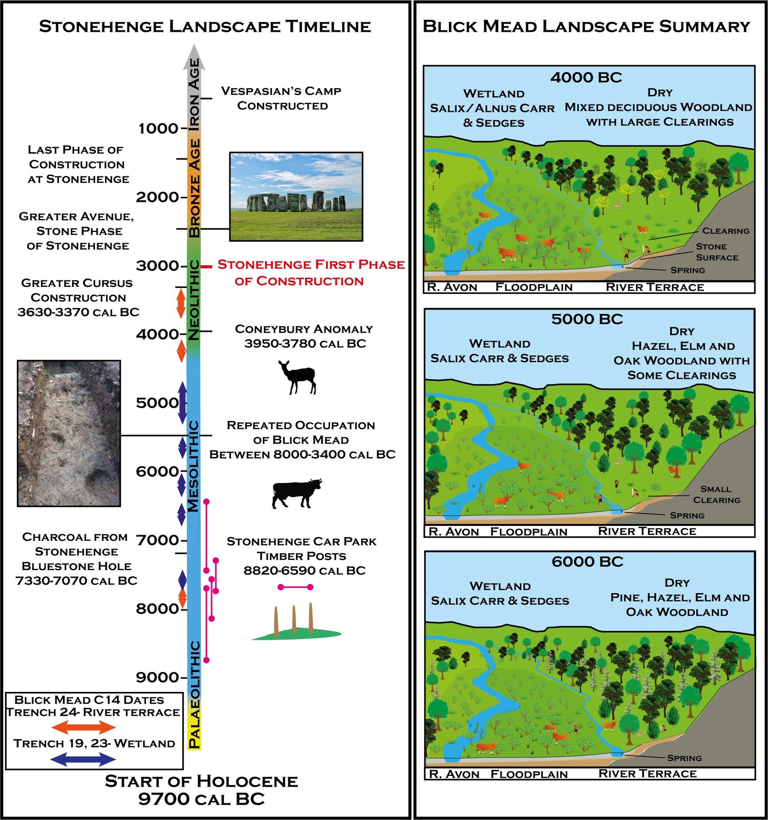
“The Coneybury Anomaly is around 1.4 kilometres east-by-southeast of the Stonehenge monument, which can be seen from the site. There are extensive views south-east across the Avon valley, and west towards Normanton Down. The pit is not obvious on the ground and was discovered as a geophysical anomaly (hence the name) as part of the excavations of the Coneybury Henge, which is some 12 metres south-west of the Anomaly.”
https://en.wikipedia.org/wiki/Coneybury_Anomaly#Location
15 posted on
05/03/2022 10:14:20 AM PDT by
BenLurkin
((The above is not a statement of fact. It is either opinion, or satire. Or both.))
To: SunkenCiv
Blick mead...

18 posted on
05/03/2022 11:52:34 AM PDT by
moovova
To: SunkenCiv
Oops, my bad...wrong link...
Blick mead...

19 posted on
05/03/2022 11:52:50 AM PDT by
moovova
To: SunkenCiv
#1 graphic. Where are the housing developments?
20 posted on
05/03/2022 11:55:20 AM PDT by
minnesota_bound
(Need more money to buy gas)
To: SunkenCiv
They were smart to build right on the main highway.


22 posted on
05/03/2022 11:58:09 AM PDT by
moovova
FreeRepublic.com is powered by software copyright 2000-2008 John Robinson