Posted on 10/05/2005 8:27:22 AM PDT by libtoken
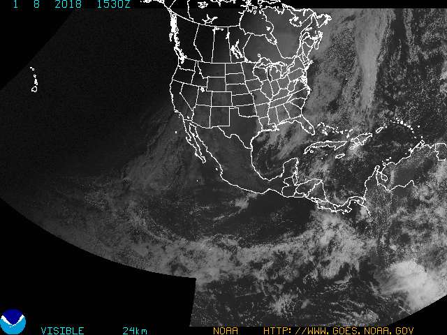
Models are stating south and/or west coast FL may get wet after the next 48 hours from the next disturbance off the Yucatan (son of Stan, probably will be called Vince).
From various weatherboards:
TROPICAL DEPRESSION INVEST (AL932005) ON 20051005 1200 UTC
...00 HRS... ...12 HRS... ...24 HRS... ...36 HRS... 051005 1200 051006 0000 051006 1200 051007 0000
LAT LON LAT LON LAT LON LAT LON BAMD 20.0N 87.0W 21.3N 86.1W 22.8N 85.1W 24.6N 84.4W BAMM 20.0N 87.0W 21.3N 86.2W 22.7N 85.2W 24.4N 84.1W A98E 20.0N 87.0W 20.8N 86.3W 22.3N 85.1W 24.1N 84.0W LBAR 20.0N 87.0W 21.1N 86.5W 22.4N 86.2W 24.3N 85.9W SHIP 20KTS 29KTS 38KTS 48KTS DSHP 20KTS 29KTS 38KTS 48KTS
...48 HRS... ...72 HRS... ...96 HRS... ..120 HRS... 051007 1200 051008 1200 051009 1200 051010 1200
LAT LON LAT LON LAT LON LAT LON BAMD 26.8N 83.9W 32.3N 79.2W 37.5N 70.6W 39.9N 64.0W BAMM 26.7N 83.1W 31.6N 77.7W 34.6N 70.8W 35.0N 67.6W A98E 26.5N 83.0W 30.7N 80.9W 33.9N 75.5W 34.8N 72.2W LBAR 26.3N 86.7W 29.7N 85.3W 32.1N 80.6W 32.6N 76.8W SHIP 56KTS 65KTS 66KTS 60KTS DSHP 56KTS 47KTS 47KTS 42KTS
...INITIAL CONDITIONS... LATCUR = 20.0N LONCUR = 87.0W DIRCUR = 50DEG SPDCUR = 5KT LATM12 = 19.4N LONM12 = 87.7W DIRM12 = 70DEG SPDM12 = 5KT LATM24 = 19.2N LONM24 = 88.7W WNDCUR = 20KT RMAXWD = 40NM WNDM12 = 15KT CENPRS = 1006MB OUTPRS = 1008MB OUTRAD = 150NM SDEPTH = D RD34NE = 0NM RD34SE = 0NM RD34SW = 0NM RD34NW = 0NM
And from a listing of latitude/longitude some FL cities:
(See your place, pick your poison from the models which currently send this everywhere but the FL panhandle (and the FL panhandle may come back under the gun too)).
[AQQ] 29.73 85.03 29 43 47 85 1 47 Apalachicola,FL [90J] 29.12 81.57 29 7 12 81 34 11 AstorNAS,FL [AGR] 28.08 81.55 28 4 47 81 33 0 AvonParkG,FL [XMR] 28.47 80.55 28 28 11 80 33 0 CapeCanaveral,FL [NZC] 30.22 81.88 30 13 11 81 52 47 Cecil,FL [CEW] 30.78 86.52 30 46 48 86 31 11 Crestview,FL [CTY] 29.62 83.10 29 37 12 83 5 59 CrossCity,FL [DAB] 29.18 81.05 29 10 48 81 3 0 DaytonaBeach,FL [EGI] 30.65 86.52 30 38 59 86 31 11 DukeFld,FL [VPS] 30.48 86.53 30 28 47 86 31 47 EglinAFB,FL [X91] 27.60 82.77 27 36 0 82 46 11 EgmontKey,FL [FXE] 26.13 80.13 26 7 47 80 7 47 FortLauderd,FL [FMY] 26.58 81.87 26 34 47 81 52 12 FortMyers,FL [FLL] 26.07 80.15 26 4 11 80 9 0 FtLauderdale,FL [RSW] 26.65 81.87 26 38 59 81 52 12 FtMyers,FL [GNV] 29.68 82.27 29 40 48 82 16 11 Gainesville,FL [HST] 25.48 80.38 25 28 47 80 22 47 Homestead,FL [HRT] 30.43 86.68 30 25 48 86 40 48 HurlburtFld,FL [CRG] 30.33 81.52 30 19 47 81 31 11 Jacksonville,FL [JAX] 30.50 81.70 30 30 0 81 41 59 Jacksonville,FL [NIP] 30.23 81.68 30 13 47 81 40 48 Jacksonville,FL [EYW] 24.55 81.75 24 32 59 81 45 0 KeyWest,FL [NQX] 24.57 81.68 24 34 11 81 40 48 KeyWestNAS,FL [LAL] 28.03 81.95 28 1 48 81 56 59 Lakeland,FL [MCF] 27.85 82.52 27 51 0 82 31 11 MacdillAFB,FL [MAI] 30.84 85.18 30 50 24 85 10 48 Marianna,FL [NRB] 30.40 81.42 30 23 59 81 25 11 MayportNAS,FL [MLB] 28.10 80.63 28 6 0 80 37 47 Melbourne,FL [MIA] 25.82 80.28 25 49 11 80 16 47 MiamiIntl,FL [OPF] 25.92 80.28 25 55 12 80 16 47 Miami/Opa,FL [TMB] 25.65 80.43 25 38 59 80 25 48 Miami/Tamiami,FL [APF] 26.13 81.80 26 7 47 81 48 0 Naples,FL [X68] 28.62 80.68 28 37 12 80 40 48 NasaShuttle,FL [MCO] 28.43 81.32 28 25 48 81 19 11 Orlando,FL [ORL] 28.55 81.33 28 32 59 81 19 48 Orlando,FL [PFN] 30.20 85.68 30 12 0 85 40 48 PanamaCity,FL [COF] 28.23 80.60 28 13 47 80 35 59 PatrickAFB,FL [NPA] 30.35 87.32 30 21 0 87 19 11 Pensacola,FL [PNS] 30.47 87.20 30 28 11 87 11 59 Pensacola,FL [TBW] 27.97 82.60 27 58 11 82 35 59 Ruskin,FL [PIE] 27.92 82.68 27 55 12 82 40 48 SaintPeters,FL [SFB] 28.78 81.25 28 46 48 81 15 0 Sanford,FL [SRQ] 27.40 82.55 27 23 59 82 33 0 Sarasota,FL [TLH] 30.38 84.37 30 22 47 84 22 12 Tallahassee,FL [TPA] 27.97 82.53 27 58 11 82 31 47 TampaIntl,FL [TIX] 28.52 80.80 28 31 12 80 48 0 Titusville,FL [PAM] 30.07 85.58 30 4 11 85 34 48 TyndallAFB,FL [VRB] 27.65 80.42 27 38 59 80 25 11 VeroBeach,FL [PBI] 26.68 80.12 26 40 48 80 7 12 WPalmBeach,FL [NSE] 30.72 87.02 30 43 11 87 1 11 WhitingFld,FL
drat, the format did not post right.
I thought Timmy was out there. When did we jump to Vince.
"Tammy" on EAST COAST of FL, Vince off Yucatan.........
Vince is the blob-o-stan that floated off the Yucatan.
When does hurricane season end?
Oct. or Nov.?
What a relief it will be when it does end.
 Vince is all business and rock and roll on the side...
Nov.30
Do you know what time 1430Z means in plain English?
Thanks!
I never thought Motley Crue would be worked into a hurricane thread...
Son of Stan, well at least it's not the Son of Sam.
10:30 am EDT.
You can see it breaking off the Yucatan and heading NE at this link: http://orca.rsmas.miami.edu/wximages/jet/1_05/anis.html
That would be 2:30 PM GMT, or 9:30 EST, or 10:30 current Eastern DST.
They are already up to the V's with Vince. What name are they going to use for "X"? Xerxes? Xavier? Xerox?
2:30 pm London........
Just Plain "X" as in Rita X...........
Son of S(a)tan?..........
Disclaimer: Opinions posted on Free Republic are those of the individual posters and do not necessarily represent the opinion of Free Republic or its management. All materials posted herein are protected by copyright law and the exemption for fair use of copyrighted works.