Skip to comments.
NASA's new Mars camera gives clear view of planet
Spaceflight Now ^
| September 29, 2006
| NASA
Posted on 09/29/2006 7:44:27 PM PDT by cabojoe
Mars is ready for its close-up. The highest-resolution camera ever to orbit Mars is returning low-altitude images to Earth from NASA's Mars Reconnaissance Orbiter.
Rocks and surface features as small as armchairs are revealed in the first image from MRO since the spacecraft maneuvered into its final, low-altitude orbital path. The imaging of the red planet at this resolution heralds a new era in Mars exploration.
The image of a small fraction of Mars' biggest canyon reached Earth on Friday, the beginning of a week of tests for the High Resolution Imaging Science Experiment and other instruments on NASA's Mars Reconnaissance Orbiter.
"We are elated at the sharpness of the image, revealing such fine detail in the landscape," said Dr. Alfred McEwen of the University of Arizona, Tucson, who is the principal investigator for this camera. The target area includes the deepest part of Ius Chasma, one portion of the vast Valles Marineris canyon. Valles Marineris is the largest known canyon in the solar system, as long as the distance from California to New York.
The camera returned test images after Mars Reconnaissance Orbiter went into orbit around Mars on March 10, 2006, but those were from altitudes more than eight times as high as the orbiter is flying now. Since March, the spacecraft has shrunk its orbit by dipping more than 400 times into the top of the Martian atmosphere to shave velocity. It is now flying in its final, nearly circular orbit at altitudes of 250 to 316 kilometers (155 to 196 miles). The orbit will remain this shape and size for the mission's two-year primary science phase, which begins in November.
During its primary science phase, Mars Reconnaissance Orbiter will return more data about the red planet than all previous missions combined, pouring data to Earth at about 10 times the rate of any earlier Mars spacecraft. Scientists will analyze the information to gain a better understanding of the distribution and history of Mars' water -- whether ice, vapor or liquid -- and of the processes that formed and modified the planet's surface.
In addition to the high-resolution camera, the orbiter's science payload includes a mineral-identifying spectrometer, a ground-penetrating radar, a context camera for imaging wide swaths of the surface, a wide-angle color imager for monitoring the entire planet daily, and an instrument for mapping and monitoring water vapor and other constituents in the atmosphere.
For most of October, Mars will be passing nearly behind the sun from Earth's perspective. Communication will be intermittent. Activities will be minimal for Mars Reconnaissance Orbiter and other spacecraft at Mars during this time, and they will resume in early November.
The mission is managed by NASA's Jet Propulsion Laboratory, a division of the California Institute of Technology, Pasadena, for the NASA Science Mission Directorate, Washington. Lockheed Martin Space Systems, Denver, is the prime contractor and built the spacecraft. The High Resolution Imaging Science Experiment is operated by the University of Arizona and the instrument was built by Ball Aerospace and Technology Corp., Boulder, Colo.
TOPICS: Miscellaneous; News/Current Events
KEYWORDS: mars; mro; nasa
Navigation: use the links below to view more comments.
first 1-20, 21-40, 41-47 next last
High Resolution Here
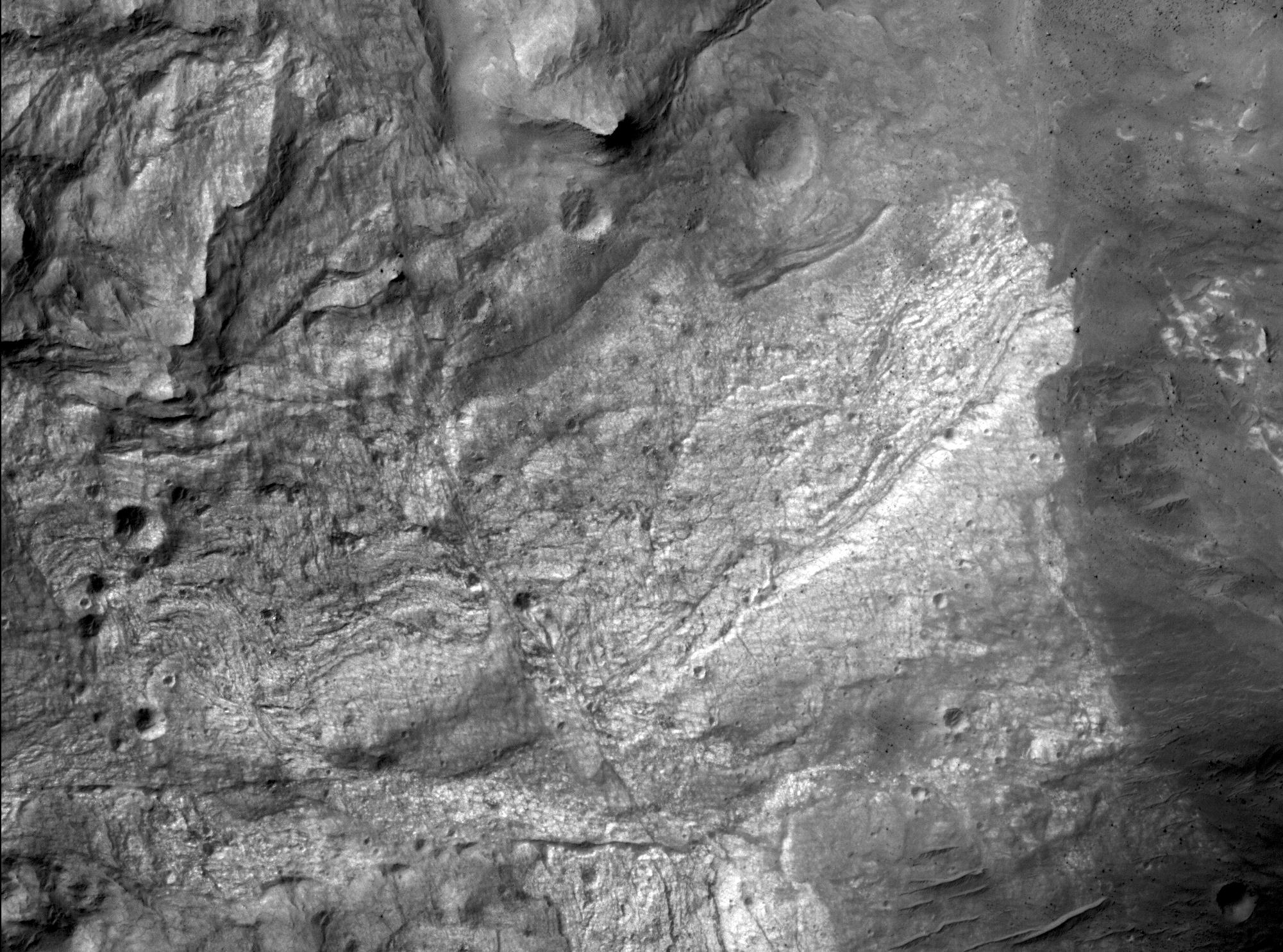
The high resolution camera on NASA's Mars Reconnaissance Orbiter captured its first image of Mars in the mapping orbit, demonstrating the full resolution capability, on Sept. 29, 2006. The High Resolution Imaging Science Experiment (HiRISE) acquired this image at 8:16 AM (Pacific Time), and parts of the image became available to the HiRISE team at 1:30 PM. With the spacecraft at an altitude of 280 kilometers (174 miles), the image scale is 29.7 centimeters per pixel (about 12 inches per pixel). This sub-image covers a small portion of the floor of Ius Chasma, one branch of the giant Valles Marineris system of canyons. The image illustrates a variety of processes that have shaped the Martian surface. There are bedrock exposures of layered materials, which could be sedimentary rocks deposited in water or from the air. Some of the bedrock has been faulted and folded, perhaps the result of large-scale forces in the crust or from a giant landslide. The darker unit of material at right includes many rocks. The image resolves rocks as small as small as 90 centimeters (3 feet) in diameter. At bottom right are a few dunes or ridges of windblown sand. If a person was located on this part of Mars, he or she would just barely be visible in this image.
1
posted on
09/29/2006 7:44:29 PM PDT
by
cabojoe
To: KevinDavis
2
posted on
09/29/2006 7:45:52 PM PDT
by
trashcanbred
(Anti-social and anti-socialist)
To: cabojoe
Bout time, I've been waiting for the thing to start sending pictures back.
3
posted on
09/29/2006 7:47:22 PM PDT
by
cripplecreek
(If stupidity got us into this mess, then why can't it get us out?)
To: cabojoe
Amazing cabojoe.
4
posted on
09/29/2006 7:48:08 PM PDT
by
fatima
To: RightWhale; Brett66; xrp; gdc314; anymouse; NonZeroSum; jimkress; discostu; The_Victor; ...
5
posted on
09/29/2006 7:52:06 PM PDT
by
KevinDavis
(Nancy you ignorant Slut!!!!!)
To: cabojoe
Mars Mineral Mapper Flips Its Lid
Full Story
NASA's latest orbiter to visit Mars achieved another mark of success this week. The mineral-mapping instrument on Mars Reconnaissance Orbiter has successfully removed its lens cover and is ready to start observing the planet. This comes on the heels of a successful test of the orbiter's subsurface radar antenna. This period of powering on instruments and completing calibrations leads up to the orbiter's primary science phase, beginning in November 2006.
6
posted on
09/29/2006 7:52:24 PM PDT
by
cabojoe
To: cabojoe
Cool, but I don't see any Wal*Mart or aliens.
7
posted on
09/29/2006 7:55:52 PM PDT
by
Paladin2
(Islam is the religion of violins, NOT peas.)
To: Paladin2
A human would be barely visible, dunno about little green men.
8
posted on
09/29/2006 7:56:41 PM PDT
by
cabojoe
To: cabojoe
Wow,, that is excellent quality imaging. Thanks!
Looking forward to lots of interesting images from the Red Planet for the forseeable future.
9
posted on
09/29/2006 7:57:12 PM PDT
by
NormsRevenge
(Semper Fi ......Help the "Pendleton 8' and families -- http://www.freerepublic.com/~normsrevenge/)
To: cabojoe
the image scale is 29.7 centimeters per pixel (about 12 inches per pixel).
Maybe now we'll find the remains of the Polar Lander and Beagle II.
To: cabojoe
That's an incredible amount of cratering. I had no idea that there were so many strikes on Mars. And I had assumed that the environmental degradation of the strikes would have been far more severe.
I wonder what the age range of those impacts are. And how much this might affect manned exploration - if strikes are that common, it might affect how the exploration systems are designed.
11
posted on
09/29/2006 8:07:49 PM PDT
by
kingu
(No, I don't use sarcasm tags - it confuses people.)
To: kingu
The atmosphere is too thin to slow meteorites down much.
12
posted on
09/29/2006 8:09:24 PM PDT
by
cripplecreek
(If stupidity got us into this mess, then why can't it get us out?)
To: cabojoe
13
posted on
09/29/2006 8:10:26 PM PDT
by
GOPJ
(Women who vote for democrats should be fitted for a burqa - freeper OrioleFan)
To: cabojoe
Tell them to get some decent pictures of Cydonia this time !!!!
14
posted on
09/29/2006 8:14:22 PM PDT
by
Centurion2000
("Be polite and courteous, but have a plan to KILL everybody you meet.")
To: cabojoe
Will they be able to spot the flag left by the astronauts as per Jackson-Lee? /s
15
posted on
09/29/2006 8:17:13 PM PDT
by
HuntsvilleTxVeteran
("Remember the Alamo, Goliad and WACO, It is Time for a new San Jacinto")
To: Centurion2000
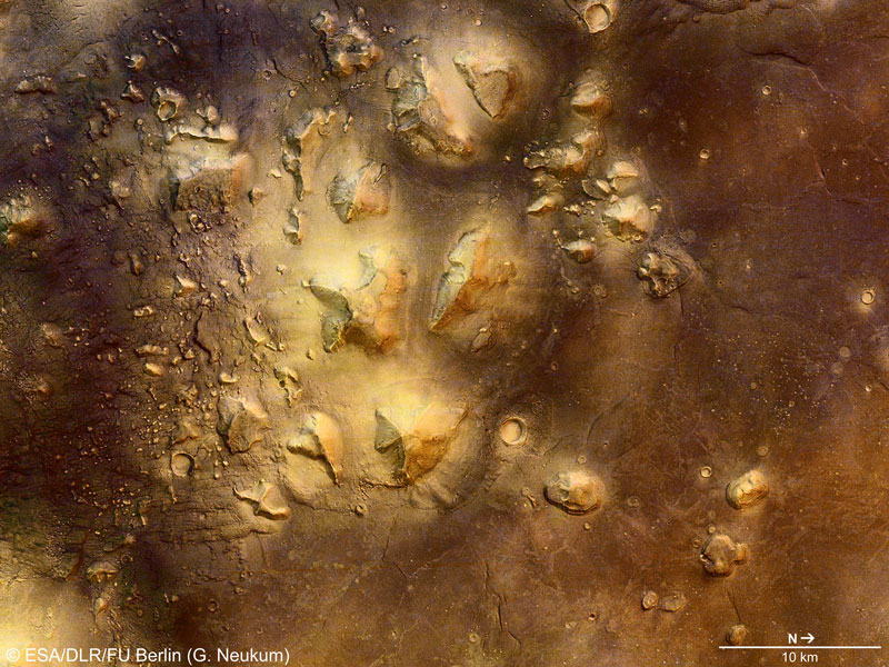
The unusual stone mesas of the Cydonia region on Mars are quite striking in appearance. Last week, the Mars Express project released a new close-up image of a portion of the Cydonia region on Mars. This new image, taken by the robotic Mars Express spacecraft now orbiting Mars, shows an area about 90 kilometers wide. In the far lower right of the above image, a particularly picturesque mesa can be seen as the upper right of the two mesas visible there. This mesa, when lit from just the right sun angle, can appear similar to a human face and became famous as the Face on Mars in 1976 Viking orbiter images. Better images show it to be just an interesting mesa. Such complex looking landforms in the Cydonia region are thought to be the result of landslides and erosion of the ancient Martian crust.
16
posted on
09/29/2006 8:17:32 PM PDT
by
cabojoe
To: Paladin2
I think there's a rusty old Ford in the ditch over there though.
17
posted on
09/29/2006 8:21:00 PM PDT
by
DanielLongo
(Don't tread on me)
To: kingu
And I had assumed that the environmental degradation of the strikes would have been far more severe. FYI, the air pressure at 'sea level' on Mars is less then the air pressure at 100,000 feet (18.93 miles) on Earth ... not much wind.
18
posted on
09/29/2006 8:21:18 PM PDT
by
Centurion2000
("Be polite and courteous, but have a plan to KILL everybody you meet.")
To: cabojoe
Criminy .... still not enough detail to rule out artificiality. Guess we'll just have to land there and check it out by hand.
19
posted on
09/29/2006 8:22:38 PM PDT
by
Centurion2000
("Be polite and courteous, but have a plan to KILL everybody you meet.")
To: Centurion2000
I've had my two monthly drinks, so I have to stop posting, but
here is the APOD pic of the face on Mars.
20
posted on
09/29/2006 8:26:19 PM PDT
by
cabojoe
Navigation: use the links below to view more comments.
first 1-20, 21-40, 41-47 next last
Disclaimer:
Opinions posted on Free Republic are those of the individual
posters and do not necessarily represent the opinion of Free Republic or its
management. All materials posted herein are protected by copyright law and the
exemption for fair use of copyrighted works.
FreeRepublic.com is powered by software copyright 2000-2008 John Robinson

