Skip to comments.
Lava From Kilauea Volcano Reaches Well at Geothermal Power Plant
https://gizmodo.com ^
| 5/28/18
| George Dvorsky
Posted on 05/28/2018 9:36:32 AM PDT by BBell
click here to read article
Navigation: use the links below to view more comments.
first previous 1-20, 21-40, 41-60, 61 next last
To: PGR88
Pāhoehoe lava advancing west from fissure 7 (lava fountain in background) on Leilani Avenue. Fissure 7 activity increased overnight, with lava fountains reaching 50 to 60 m (164 to 197 ft) high. (5/27/2018)

Aerial view of Kīlauea Volcano's summit caldera and an ash plume billowing from Halema‘uma‘u, a crater within the caldera. The USGS–Hawaiian Volcano Observatory and Hawai‘i Volcanoes National Park's Jaggar Museum are visible on the caldera rim (center right); Kīlauea Military Camp can be seen in the lower right. Photo courtesy of the Civil Air Patrol. (5/26/2018) 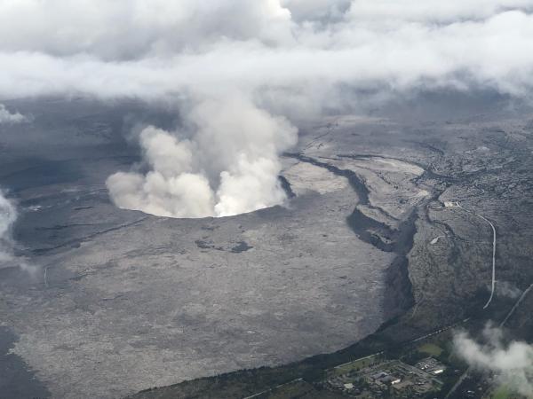
21
posted on
05/28/2018 10:59:33 AM PDT
by
caww
To: BBell
Baraq 0bama’s fault.
5.56mm
22
posted on
05/28/2018 11:02:52 AM PDT
by
M Kehoe
To: caww
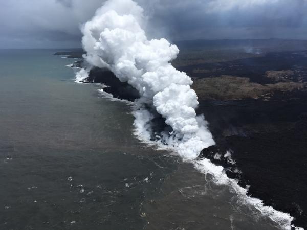
An aerial view, looking west, of the two active ocean entries on Kīlauea Volcano's lower East Rift Zone.... The large white plume (foreground) is the eastern ocean entry; the weaker, western plume can be seen in the distance.... The white plume, referred to as "laze," is a mixture of condensed acidic steam, hydrochloric acid gas, and tiny shards of volcanic glass that can irritate lungs, eyes and skin.
23
posted on
05/28/2018 11:02:57 AM PDT
by
caww
To: bell; All
Thanks to all posters. Interesting.
24
posted on
05/28/2018 11:03:02 AM PDT
by
PGalt
To: caww
That top pic in 21 is pretty impressive. Nothing lowers the price of real estate like a 200-ft lava fountain in the backyard.
To: caww
Thanks for the pics.
Jaggar has a museum on the Big island?
5.56mm
26
posted on
05/28/2018 11:05:34 AM PDT
by
M Kehoe
To: caww
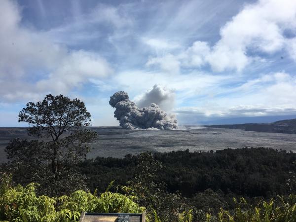
View of a rising ash plume from Halema‘uma‘u, a crater 'at the summit of Kīlauea,' late (May 24, 2018), as seen from the caldera rim near Volcano House. USGS scientists are stationed at this vantage point to track the ongoing summit explosions.
27
posted on
05/28/2018 11:06:04 AM PDT
by
caww
To: sheana
And what triggered the earthquakes? (if you really want to stay on-message for ‘green’ energy, say “global warming”.
When is the last time you saw a volcano erupt next to a coal fired power plant?
28
posted on
05/28/2018 11:06:32 AM PDT
by
PAR35
To: caww
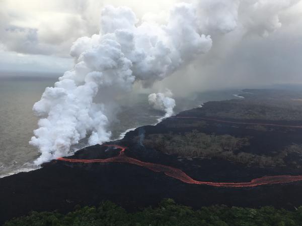
Ongoing lower East Rift Zone eruption, HVO geologists noted that fissures 6, 13 and 22 were still erupting, with two channelized flows reaching the ocean. The eastern lava channel splits just before reaching the ocean, so it has two entry points, creating a total of three ocean entries on the flow field.
29
posted on
05/28/2018 11:09:29 AM PDT
by
caww
To: BBell
It is now possible to tap the geothermal heat on the surface and need not drill for it
30
posted on
05/28/2018 11:11:44 AM PDT
by
bert
((K.E. N.P. N.C. +12 ..... Greetings Jacques. The revolution is coming))
To: caww
Is it going to be a catastrophe!!! I honestly don’t know how bad it could get. It seems like it is being monitored alright. It was known that Mt. St. Helens was going to erupt. It was just not known when but there were evacuations done before the big eruption.
31
posted on
05/28/2018 11:14:11 AM PDT
by
BBell
(calm down and eat your sandwiches)
To: caww
For the record..... there are several very good youtube videos of ten minutes or so describing the events very well
32
posted on
05/28/2018 11:15:32 AM PDT
by
bert
((K.E. N.P. N.C. +12 ..... Greetings Jacques. The revolution is coming))
To: PAR35
first group of wells location

33
posted on
05/28/2018 11:29:24 AM PDT
by
caww
To: BBell
"Path of Destruction"....From 3,000 feet above, one can see the path of destruction left by the lava flowing from the volcano Kilauea.

34
posted on
05/28/2018 11:31:18 AM PDT
by
caww
To: caww
Vocano 'summit' from space...5/28/2018

35
posted on
05/28/2018 11:36:01 AM PDT
by
caww
To: caww
Moon, Jupiter and ash from Kilauea volcano 95/27/2018

36
posted on
05/28/2018 11:41:04 AM PDT
by
caww
To: CJ Wolf
That map shows that people cause earthquakes. Likely due to all the little micro pounding of their constant foot steps. Look at all those footsteps leading north to California! Unchecked immigration is a direct cause of earthquakes (hey, if the Left can use half-baked theories, let's return fire).
37
posted on
05/28/2018 11:44:04 AM PDT
by
Charles Martel
(Progressives are the crab grass in the lawn of life.)
To: caww
This was an open cow pasture with tall grass just a few days ago

38
posted on
05/28/2018 11:44:54 AM PDT
by
caww
To: caww
This picture of the proximity of lava to the Puna Geothermal Venture plant 3 days ago. 5/25/2018

39
posted on
05/28/2018 11:50:48 AM PDT
by
caww
To: caww
Aerial view proximity of lava to the Puna Geothermal Venture plant

40
posted on
05/28/2018 11:58:40 AM PDT
by
caww
Navigation: use the links below to view more comments.
first previous 1-20, 21-40, 41-60, 61 next last
Disclaimer:
Opinions posted on Free Republic are those of the individual
posters and do not necessarily represent the opinion of Free Republic or its
management. All materials posted herein are protected by copyright law and the
exemption for fair use of copyrighted works.
FreeRepublic.com is powered by software copyright 2000-2008 John Robinson