Free Republic
Browse · Search
News/Activism
Topics · Post Article

Skip to comments.

Tropical Storm Warning for Northern Gulf of Mexico
NHC/NOAA ^ | September 3, 2018 | NHC/NOAA

Posted on 09/03/2018 4:25:24 AM PDT by NautiNurse

Labor Day 2018 begins with a developing tropical system affecting South Florida. Conditions appear to be conducive for development as the system moves over the Florida Keys and into the Gulf of Mexico Monday.

Public Advisories
NHC Discussions
FL Radar Map with Alberto Track Overlay


TOPICS: Extended News; US: Alabama; US: Florida; US: Louisiana; US: Mississippi
KEYWORDS: tropical
Navigation: use the links below to view more comments.
first previous 1-2021-4041-6061-8081-88 next last
To: NautiNurse

I should.I hate to bother him with stuff like this when we all know what he has on his plate. I guess after the Nov. elections are done I”ll send off some stuff.He’s got as full a plate as anyone has ever had I hate to add to it now.


41 posted on 09/03/2018 10:15:26 AM PDT by rodguy911 (Home of the free because of the brave! MAGA!!)
[ Post Reply | Private Reply | To 40 | View Replies]

To: rodguy911
Gordon's eye appears to be wrapping up with some strong convection on the western edge. Moving off the FL peninsula at Everglades City and Marco Island.


42 posted on 09/03/2018 10:25:51 AM PDT by NautiNurse (Do not make me pay Ferrari prices for Chevy Vega health insurance.)
[ Post Reply | Private Reply | To 41 | View Replies]

To: NautiNurse

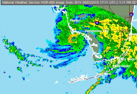
Great shot NN! Really shows where the eye is.
I wonder if it will go anywhere near buoy
42023 which is actually live.


43 posted on 09/03/2018 10:32:21 AM PDT by rodguy911 (Home of the free because of the brave! MAGA!!)
[ Post Reply | Private Reply | To 42 | View Replies]

To: rodguy911

No shortage of warm water with SST 82-85ºF.


44 posted on 09/03/2018 10:45:29 AM PDT by NautiNurse (Do not make me pay Ferrari prices for Chevy Vega health insurance.)
[ Post Reply | Private Reply | To 43 | View Replies]

To: NautiNurse

Thanks for all you do bump


45 posted on 09/03/2018 1:41:41 PM PDT by DAVEY CROCKETT (Thank you President Trump, Amos5:15 Hate evil, love good, And establish justice in the gate)
[ Post Reply | Private Reply | To 1 | View Replies]

To: NautiNurse
Windy.com has an interesting take on where Florence will be by the middle of next week. Florence may want be heading for Florence (SC). Restart the 10-day forecast (it does adjust as the week goes on). If she doesn't shear, she may be of some concern...
46 posted on 09/03/2018 4:39:47 PM PDT by Hatteras
[ Post Reply | Private Reply | To 1 | View Replies]

To: abb; abbi_normal_2; aberaussie; abner; AbsoluteGrace; alancarp; Alas Babylon!; Alia; ...
TS Gordon strengthening as it moves away from the FL peninsula...

A Hurricane Warning is in effect for...
Mouth of the Pearl River to the AL-FL Border.

A Tropical Storm Warning is in effect for...
West of the Mouth of the Pearl River to east of Morgan City, LA,
including Lake Pontchartrain and Lake Maurepas, AL-FL Border
to Okaloosa-Walton County Line.

Location: About 95 mi W of Ft. Myers FL
About 385 mi ESE of the mouth of the Mississippi River
Max sustained winds 60 MPH
Moving WNW at 17 MPH
Minimum pressure 1003 mb


On/Off Hurricane List Mash Here-->

47 posted on 09/03/2018 5:08:37 PM PDT by NautiNurse (Do not make me pay Ferrari prices for Chevy Vega health insurance.)
[ Post Reply | Private Reply | To 1 | View Replies]

To: Hatteras

Interesting...


48 posted on 09/03/2018 5:12:17 PM PDT by NautiNurse (Do not make me pay Ferrari prices for Chevy Vega health insurance.)
[ Post Reply | Private Reply | To 46 | View Replies]

To: NautiNurse

For sure, probably an 80 mph storm when it hits.
Im more concerned about whats coming off of Africa over the next few weeks.


49 posted on 09/03/2018 5:30:16 PM PDT by rodguy911 (Home of the free because of the brave! MAGA!!)
[ Post Reply | Private Reply | To 44 | View Replies]

To: NautiNurse

1. A tropical wave located a few hundred miles southeast of the Cabo
Verde Islands continues to produce a large area of disorganized
showers and thunderstorms. Gradual development of this system is
expected, and it could become a tropical depression late this week
or this weekend while it moves westward to west-northwestward across
the eastern tropical Atlantic.
* Formation chance through 48 hours...low...10 percent.
* Formation chance through 5 days...medium...50 percent.

Forecaster Cangialosi


50 posted on 09/03/2018 5:32:00 PM PDT by rodguy911 (Home of the free because of the brave! MAGA!!)
[ Post Reply | Private Reply | To 44 | View Replies]

To: NautiNurse

Hey you:) Good to see you.

We had some funny weather here today, not the norm. Like mini tropical bands. My corgi and I got surprised by one while out for a walk. We were thoroughly soaked. She kept looking at me with the Why Did You Do This? face...lol.

Been a quiet season, we’ll see how it goes.


51 posted on 09/03/2018 5:57:24 PM PDT by SE Mom (Screaming Eagle mom)
[ Post Reply | Private Reply | To 47 | View Replies]

To: SE Mom

And Corgis dry so easily and without shedding a single hair.


52 posted on 09/03/2018 6:01:53 PM PDT by KC Burke (If all the world is a stage, I would like to request my lighting be adjusted.)
[ Post Reply | Private Reply | To 51 | View Replies]

To: SE Mom
A lot of the peninsula received outer bands from Gordon today. I think we had just one. Maybe some later tonight.

Don't forget chocolate!

53 posted on 09/03/2018 6:05:24 PM PDT by NautiNurse (Do not make me pay Ferrari prices for Chevy Vega health insurance.)
[ Post Reply | Private Reply | To 51 | View Replies]

To: rodguy911
Im more concerned about whats coming off of Africa over the next few weeks.

I think my record is tracking three active storms simultaneously, back in 2005. 2004-2005 were a couple of dizzying seasons.

54 posted on 09/03/2018 6:11:08 PM PDT by NautiNurse (Do not make me pay Ferrari prices for Chevy Vega health insurance.)
[ Post Reply | Private Reply | To 49 | View Replies]

To: NautiNurse
Hi NN...

I'll be installing my shutters early in the morning.

55 posted on 09/03/2018 6:46:30 PM PDT by blam
[ Post Reply | Private Reply | To 2 | View Replies]

To: blam

Thanks for checking in! Been hoping to hear from you. Looking forward to your local reports. Godspeed.


56 posted on 09/03/2018 7:49:54 PM PDT by NautiNurse (Do not make me pay Ferrari prices for Chevy Vega health insurance.)
[ Post Reply | Private Reply | To 55 | View Replies]

To: NautiNurse

Latest as of 4am CDT, Gordon expected to hit late this evening, and to strengthen into hurricane range just before landfall

From
https://www.nhc.noaa.gov/refresh/graphics_at2+shtml/031822.shtml?cone#contents

1. Gordon is expected to bring life-threatening storm surge and hurricane conditions to portions of the central Gulf Coast where a Storm Surge Warning and Hurricane Warning are in effect. Residents in these areas should listen to advice from their local officials.
All preparations to protect life and property should be rushed to completion, as tropical storm conditions are expected to arrive in the warning areas this afternoon.

2. Heavy rainfall from Gordon will affect the western Florida Panhandle, southern Alabama, southern Mississippi and Louisiana,where totals could reach as high as 12 inches. This rainfall could cause flash flooding.

FORECAST POSITIONS AND MAX WINDS

INIT 04/0900Z 27.7N 85.7W 55 KT 65 MPH
12H 04/1800Z 29.0N 87.5W 65 KT 75 MPH
24H 05/0600Z 30.7N 89.6W 55 KT 65 MPH...INLAND


57 posted on 09/04/2018 2:28:04 AM PDT by PapaBear3625 ("It rubs the rainbow on it's skin or it gets the diversity again!")
[ Post Reply | Private Reply | To 56 | View Replies]

To: NautiNurse

Big year,data gets better every year more info on each and every storm.


58 posted on 09/04/2018 4:01:20 AM PDT by rodguy911 (Home of the free because of the brave! MAGA!!)
[ Post Reply | Private Reply | To 54 | View Replies]

To: NautiNurse

“The National Hurricane Center has issued a hurricane warning from the mouth of the Pearl River, Mississippi, to the border between Alabama and Florida.”

https://www.wunderground.com/news/safety/hurricane/news/2018-09-03-tropical-storm-gordon-hurricane-gordon-forecast-us-gulf-coast


59 posted on 09/04/2018 7:07:49 AM PDT by jeffers
[ Post Reply | Private Reply | To 56 | View Replies]

To: NautiNurse
TS Allison was catastrophe that will never be forgotten.

I never will forget it. Like I've never forgotten about Hurricane Carla and I lived through that one too back in September 1961. Thankfully we only lost our detached garage the roof off of our home but we lost no lives in our family in that storm. We did lose some neighbors though. For many years it was ranked as the costliest and deadliest hurricane to strike Galveston and Houston since the great hurricane of 1900 that totally destroyed Galveston.

60 posted on 09/04/2018 8:06:35 AM PDT by Ron H. (Pray unceasingly - 1 Thessalonians 5:16-18)
[ Post Reply | Private Reply | To 31 | View Replies]


Navigation: use the links below to view more comments.
first previous 1-2021-4041-6061-8081-88 next last

Disclaimer: Opinions posted on Free Republic are those of the individual posters and do not necessarily represent the opinion of Free Republic or its management. All materials posted herein are protected by copyright law and the exemption for fair use of copyrighted works.

Free Republic
Browse · Search
News/Activism
Topics · Post Article

FreeRepublic, LLC, PO BOX 9771, FRESNO, CA 93794
FreeRepublic.com is powered by software copyright 2000-2008 John Robinson