Posted on 03/18/2019 6:26:10 PM PDT by KierkegaardMAN
Nebraska and Iowa have been hit hard by flooding over the past several days.
Towns have been evacuated, crops and livestock have been destroyed and people have died.
The full extent, captured at the ground level by World-Herald photographers in the field, can intimately drive that home.
But a view from above — way above — can show the catastrophic, almost unimaginable extent of the devastation.
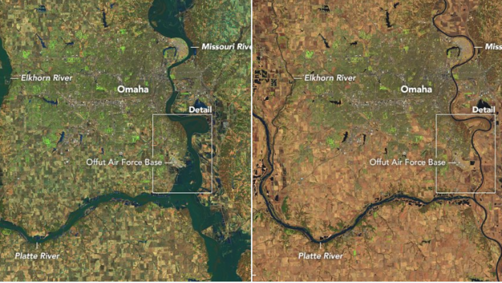
In the before-and-after visuals below, using imagery from the EU's Sentinel-2 satellite, you can see whole Nebraska towns fall victim to the floods. Waters rise, trapping communities, and the previously identifiable river banks disappear into a hazy mass.
Explore the images below, moving the slider to see before and after imagery.
(Excerpt) Read more at omaha.com ...
“You must be a digital subscriber to view this article.”
How do you get past the paywall? Outline.com doesn’t work on this one.
That web site is messed up. used two browsers both not working. Brave not working at all (cookie issue.) Firefox i seen the satellite pic for about 1/2 a second then some ad popped up over it and I can’t get rid of it.
Thank you for that pic
Thank you! I thought one could visit site for free.
Every river floods every year... The severity changes from year to year, but that’s what rivers do... I live beside one and it floods every year and two times in my lifetime has been flooded to an extreme level. If you look at the recorded history of this river, every few decades it floods to an extreme level... So that’s what happens... It’s called ‘mother nature’ and there is nothing we can do to control it completely.
Your best bet... Don’t move to a known floodplain.
It’s a mess here....
Your thoughts and prayers are always welcome!
Or, if you’re the United States government looking for a place for your Strategic Air Command headquarter, stay away from flood plains as well.
Right side photo on the far right is the Lewis and Clark route on the Missouri River.
This is a rather under reported catastrophe. I can’t imagine what it is like for those effected.
Booo
Well, now it’s a 1,000 year flood.
Shame the plains indians didn’t keep petroglyph records of those floods.
A simple sampling of current river beds with surrounding hills shows the action of weather and water for many millennia.
I read people postings all over the web about how this is the work of man-made global warming, “why, I’ve never seen flooding like this is MY lifetime.”
Short-sighted, single lifetime, no ancestral memory, just what the media feed them day, day out.
This will pass. And the glaciers may return.
“why, I’ve never seen glaciers like this in MY lifetime.”


Little bigger look at just the eastern part of Nebraska.
SAC expanded there because Offut had numerous strategic advantages, starting in the huge Martin aircraft plant after WWII. You can rest assured that they have had floods before and have full contingency plans and are carrying on the mission regardless.
It sucks. My home town is cut off.
Roads out, little drinking water..
The worst is the livestock loss. This isn’t a “normal” flood. Every dang waterway flooded in the east side of the state, and every one in the west is dealing with one of the worst blizzards in decades.
Beef will be in short supply this year.
I wish you all well out there——an awful situation.
.
are the corn or wheat crops in danger of destruction?
Fear not. There will be abundant corn, wheat and beef. But the price might not be what your used to.
Its not corn planting season yet but it is calving season. Between the floods in the mid and east and the blizzard in the west, not a great start to the AG year.
Disclaimer: Opinions posted on Free Republic are those of the individual posters and do not necessarily represent the opinion of Free Republic or its management. All materials posted herein are protected by copyright law and the exemption for fair use of copyrighted works.