Deep Impact - The Vredefort Dome
NASA Johnson Space Center (Image STS008-35-1296)
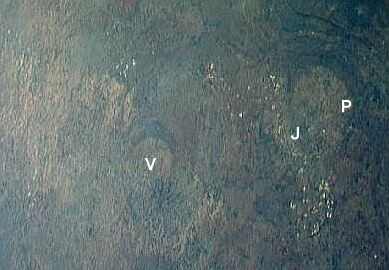
From high altitude these hills bear a strong resemblance to the larger, near-circular ring of hills north-east of Vredefort, whose northern side, the Magaliesberg hills, cuts through Pretoria (letter "P") and whose southern side, the "Witwatersrand" ridge, cuts through Johannesburg (letter "J"). These surround the uplifted area known as the "Johannesburg Dome". The white dots running in a band along the Witwatersrand are not clouds, they are the waste dumps from the gold mines along the south side of the Witwatersrand. West of Johannesburg and due north of Vredefort can be seen the gold mine dumps of Carletonville. The gold mines of Klerksdorp and Welkom lie north-west and south-west of Vredefort, and their dumps are also easily seen. Is this half ring of gold mines around Vredefort a coincidence?
NASA Johnson Space Center (Image STS51I-33-56AA)
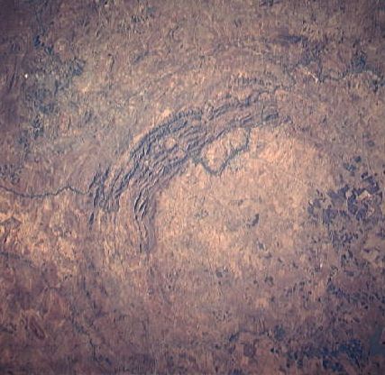
Pictured above is a higher resolution view of the Vredefort hills from space. The Vaal river meanders through the hills, flowing from north-east (upper left) to west (centre right). Parys (the Paris of South Africa!) lies on the loop of the river protruding within the ring of hills. Vredefort is close to the geometric center of the hills.
Only the north western half of the structure remains visible. The south eastern half was flooded by the sediments of the Karoo Supergroup, which cover the Free State province.
What Created the Vredefort Dome?
The Magaliesberg - Witwatersrand feature is the result of natural upliftment from below of sedimentary sandstone layers - what was once the bottom of a sea - so that the Magaliesberg rock layers slope down to the north, while the Witwatersrand rock layers slope down to the south. The "Johannesburg Dome" in the center this feature is occupied by the archean granitic crust, some 3000 to 3400 million years old.The same rock layers seen in the Witwatersrand are found in the Vredefort dome hills, but here they are found standing nearly vertically - the result of extreme upliftment.
Evidence has been found by geologists that the cause of this upliftment was an extreme impact event, caused by an asteroid some 10 kilometres in diameter. The ring of hills we see now are the eroded remains of a dome created by the rebound of the rock below the impact site after the asteroid hit. The original crater, now eroded away, is estimated to have been 250 - 300 kilometres in diameter. Some 70 cubic kilometres of rock would have been vaporised in the impact.
The Vredefort structure is currently regarded the biggest and oldest clearly visible impact structure on Earth. It just beats the Sudbury impact structure in Canada for this ranking. The Sudbury structure is some 200 km in diameter and is estimated to be 1.85 billion years old.
Evidence for four impacts even older than than Vredefort, that occurred 3.2 to 3.5 billion years ago, has been found in the greenstone rocks around Barberton in South Africa and corresponding rocks in the eastern Pilbara block of Western Australia. However, these impacts are no longer recognizable as structures on the surface like Vredefort's.
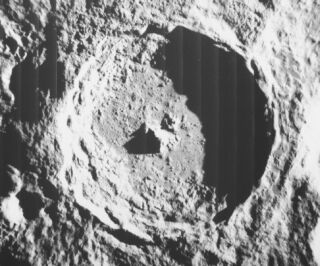
NASA Lunar Orbiter image
The central mountains in the 85 kilometre diameter lunar crater Tycho show what the Vredefort dome is the remains of - the central rebound peak, NOT the crater itself, which at Vredefort has long since eroded away. The erosion processes occuring on Earth are of course missing on the Moon, hence the "as new" appearance of Tycho.
What is the evidence for the impact at Vredefort?
The pictures below tell some of the story.
The Earth Heaved and Melted...
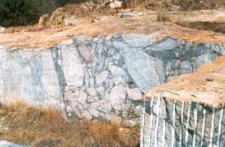
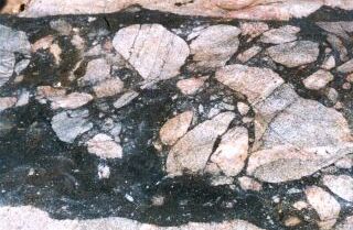
Within the ring of hills at Vredefort is found granitic gneiss rock - as in the Johannesburg Dome - which is dated at some 3200 million years old. Here a quarry at Leeuwkop near Parys reveals one of the indicators of the impact. The image above left shows the cut surface of the rock. The pale and medium greys on the left are the natural colours of the granite. But from the centre to the right edge is a wide dark grey band containing large and small fragments of the granite. This is "pseudotachylitic brecchia" - the dark grey is granite that was melted by the impact and flowed, carrying chunks of unmelted granite within the melt. The vertical face seen here is two to three metres in height.
The image above right is of a nearly horizontal exposure of pseudotachylite at the quarry. The width of the band is about one metre. Similar rock is found at elsewhere, in geological faults where rocks move against each other and melt at the interface, but this produces a melt band that is centimetres rather than metres wide as seen here.
The basement granite exposed within the ring of hills is estimated to have been seven to ten kilometres beneath the surface when the impact occurred, which is dated at 2000 million years ago. The date was established from zircon crystals found in the pseudotachylite and granophyre (below), and, more precisely, is 2023 +- 5 million years. All the covering rock has since been removed by erosion. Later the south-east part was covered by much younger Karroo rock formations.
...and Flowed and Solidified
The force of the impact produced deep fractures in the underlying rock. Rock melted by the impact flowed down into the cracks, producing what are now exposed as ridges of hard dark rock - the granophyre dykes. This contrasts with normal geological dykes, where molten rock from deeper in the earth has flowed upwards through cracks in the rock above.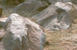
The picture above left shows one of the dykes located close to the centre of the impact, at Daskop. Its width at the surface is about three metres, but it is hundreds of metres long where it is exposed here.
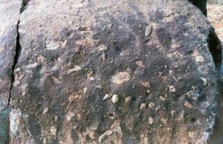
The boulder in the dyke shown above right shows the small, fractured inclusions of unmelted rock that are typically 1 - 3 cm in size. This is much smaller than the rocks embedded in the pseudotachylite at the quarry, which are up to metres in size. The small inclusions may have come from considerable distances - tens of kilometres away.
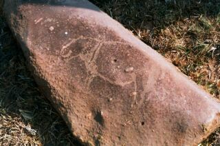
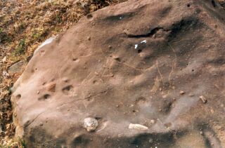
These rocks have also been the target of graffiti artists - in this case San hunters perhaps 2000 years ago. Shown above left is an engraved hippopotamus.
Pictured above right is an equally accurate engraving of a rhinoceros. Less obvious is the eland, the largest antelope, engraved inverted (from this perspective) in front of the rhino. It shows up more clearly in the large version of this image.
The Shatter Cones
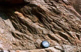
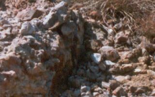
Another signature of an impact is left by the passage of shockwaves through the underlying rock. This produces fractures with a characteristic "fir tree" pattern. In this particularly clear example found next to the Vaal river at Schoemansdrif, the shock wave passed through from upper left to lower right.
The Hills uplifted around the Dome
The hills surrounding the granite dome reproduce the layered rock formations seen in Johannesburg (the Witwatersrand). The Vaal river flows westwards through gaps in the hills.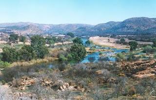
The view above left is a panorama over the Vaal river. It was taken facing west, at Schurwedraai. The next ring of hills forms the horizon.
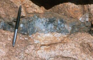
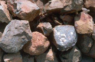
The rocks at the site where the photograph of the river was taken at Schurwedraai are quite different to the basement granite, but also show dark grey veins of pseudotachylite - melted rock. The pen gives the scale in the picture on the right.
This ring of hills comprises quartz conglomerates as found in the gold-bearing strata of the Witwatersrand reefs. The white quartz pebbles are evident. This was once the bed of a fast flowing water course which deposited grains of quartz and the pebbles. This area was mined for gold in the 1880's. However the concentration of gold was much poorer than at Johannesburg, and the diggings were soon abandoned. Old mine adits are still to be seen in the hills. This is the Amazon Reef.
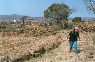
The outermost ring of hills was home to a quite different group of people in the 1500's to 1700's. These were SeSotho/SeTswana-speaking farmers. This village at Askoppies was a defensive position on the crest of the hill, but it did not save the village from destruction, by the warriors of Mzilikazi. The view shown above left looks east, back in towards the inner rings of the Vredefort dome.
The stone walls of the village are shown above right. They are made of the fine-grained grey Ventersdorp lavas that comprise this ridge. These rocks are 2700 million years old.
