Skip to comments.
Satellite data backs theory of North Korean nuclear site collapse
Science News ^
| MAY 10, 2018
| MARIA TEMMING
Posted on 05/10/2018 5:01:28 PM PDT by TigerLikesRooster
Satellite data backs theory of North Korean nuclear site collapse
Whether underground cave-ins have made the facility unusable is unknown
BY MARIA TEMMING 2:00PM, MAY 10, 2018
A new analysis of satellite images and seismic waves from North Korea’s nuclear test site support theories that the underground facility has at least partially collapsed.
Seismologists across the world have been tracking the clandestine nuclear weapons program for years by analyzing vibrations that emanate from explosions at the test site under Mount Mantap (SN: 8/5/17, p. 18). Now, researchers have paired 3-D satellite images of Mount Mantap with seismic tremor data to simulate how the mountain’s interior might have changed after a hydrogen bomb test on September 3, 2017.
The simulations indicate that the blast — which triggered an earthquake of estimated magnitude 6.3 — caused a cave-in directly above the detonation site, researchers report online May 10 in Science. The simulations also suggest that a second rock collapse, about 700 meters south of the detonation site, caused a smaller quake about eight minutes after the initial explosion.
(Excerpt) Read more at sciencenews.org ...
TOPICS: Extended News; Foreign Affairs; News/Current Events
KEYWORDS: collapse; korea; mantap; nkorea; nucleartest
Navigation: use the links below to view more comments.
first 1-20, 21-32 next last
The original article from Science:
The rise, collapse, and compaction of Mt. Mantap from the 3 September 2017 North Korean nuclear test
Abstract
Surveillance of clandestine nuclear tests relies on a global seismic network, but the potential of spaceborne monitoring has been underexploited. Here, we determined the complete surface displacement field of up to 3.5 m of divergent horizontal motion with 0.5 m of subsidence associated with North Korea’s largest underground nuclear test using satellite radar imagery. Combining insight from geodetic and seismological remote sensing, we found that the aftermath of the initial explosive deformation involved subsidence associated with sub-surface collapse and aseismic compaction of the damaged rocks of the test site. The explosive yield from the nuclear detonation with seismic modeling for 450m depth was between 120-304 kt of TNT equivalent. Our results demonstrate the capability of spaceborne remote sensing to help characterize large underground nuclear tests.
Fig. 4 Summary deformation scenario for the 3 September 2017 North Korea’s Nuclear test. The unfolding of events includes the succession of (A) explosive, (B) collapse, and (D) compaction processes, with different associated surface displacements. The implosive source (C) may be shallow and only contribute localized surface displacements. The radar imagery reveals the deformation (arrows in (D)] resulting from the three processes.

To: TigerLikesRooster; AmericanInTokyo; nuconvert; MizSterious; endthematrix; Grampa Dave; ...
2
posted on
05/10/2018 5:02:42 PM PDT
by
TigerLikesRooster
(dead parakeet + lost fishing gear = freep all day)
To: TigerLikesRooster
Titanium telephone poles from space.
3
posted on
05/10/2018 5:05:18 PM PDT
by
2ndDivisionVet
(You cannot invade the mainland US. There'd be a rifle behind every blade of grass.)
To: TigerLikesRooster
4
posted on
05/10/2018 5:06:36 PM PDT
by
Bratch
("The only thing necessary for the triumph of evil is for good men to do nothing." - Edmund Burke)
To: TigerLikesRooster

And a quick look at a map will show you why China is extremely ticked over it.
To: TigerLikesRooster
D. t = t0 +~1 week
"At least 100 workers at the Punggye-ri nuclear site are feared to have died in the accident that happened around 10 September following the regime’s sixth atomic test earlier that month, Japanese broadcaster TV Asahi reported."
To: Chad_the_Impaler
Numerous rocket launch failures and the big implosion. Trump told the Chicoms...stop him NOW.
To: 2ndDivisionVet
8
posted on
05/10/2018 5:22:15 PM PDT
by
JohnBovenmyer
(Waiting for the tweets to hatch!)
To: TigerLikesRooster
“... the mountain’s interior might have changed after a hydrogen bomb test...”
Gee, ya think? I guess they didn’t use enough 2x4s to shore it up.
9
posted on
05/10/2018 5:23:30 PM PDT
by
PLMerite
("They say that we were Cold Warriors. Yes, and a bloody good show, too." - Robert Conquest)
To: TigerLikesRooster
It’s about 80 miles from the Chinese border.
Close enough for radioactivity to waft over if the mountain opened up.
10
posted on
05/10/2018 5:30:43 PM PDT
by
MUDDOG
To: 2ndDivisionVet
Rods from God
That was a Jerry Pournelle idea from the 1950s. RIP Jerry, such a modern Renaissance Man. A true conservative. One of the few people I respected who was strongly against going into Iraq post-9/11. He was right.
11
posted on
05/10/2018 5:43:44 PM PDT
by
FreedomPoster
(Islam delenda est)
To: TigerLikesRooster
I was reading several variations of how these scientists etc. are looking at it......some saying it’s worse than they thought. At any rate it’s a pile of radio active dust and dirt! So Kim saying he would close this site is really he wants someone else to clean up the mess he left it in!
12
posted on
05/10/2018 6:01:54 PM PDT
by
caww
To: FreedomPoster
Did you know Emil Pipersky from North American?
13
posted on
05/10/2018 6:10:37 PM PDT
by
2ndDivisionVet
(You cannot invade the mainland US. There'd be a rifle behind every blade of grass.)
To: caww
Pretty much sums it up. Norks made a big mess. China told them to fix it. Norks don’t know how or the money to fix it. Here we are. Guess who will pay to clean this up.
To: stuck_in_new_orleans
......”Pretty much sums it up. Norks made a big mess. China told them to fix it. Norks don’t know how or the money to fix it. Here we are. Guess who will pay to clean this up”.....
I suspect Kims busy cleaning up bodies around the place...he doesn’t care if it kills the people doing it.
15
posted on
05/10/2018 6:22:18 PM PDT
by
caww
To: 2ndDivisionVet
I’m not familiar with him.
16
posted on
05/10/2018 6:24:20 PM PDT
by
FreedomPoster
(Islam delenda est)
To: caww
This news could create panic among rocket and nuclear scientists in N. Korea. They would probably not mind being shipped to U.S.. First, Kim will try to disperse them among civilian population, turning them into farmers and car mechanic for example. However, it is also possible that Kim Jong-un may decide to liquidate(kill) them in order to clean up evidence and keep their mouth shut.
17
posted on
05/10/2018 6:55:07 PM PDT
by
TigerLikesRooster
(dead parakeet + lost fishing gear = freep all day)
To: Snickering Hound
Northeast China (traditionally called Manchuria), the area adjacent to the Korean Peninsula, is a mining and heavy manufacturing region of China with a population over 100 million. Yeah, they’re not happy with Fat Boy’s hobby.
18
posted on
05/10/2018 7:08:09 PM PDT
by
katana
To: TigerLikesRooster
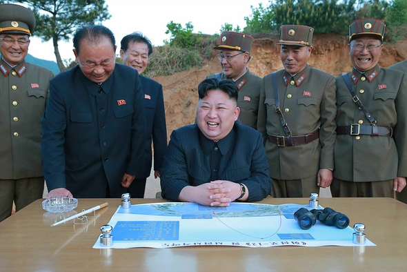
The guy in Blue in the back is the lead nuclear guy I understand......Also I understand after Russia fell apart some of their guys were sent to N.Korea to instruct them further on nuclear.....course that's been a great while now
19
posted on
05/10/2018 7:09:38 PM PDT
by
caww
To: caww
On the other hand, it would be nearly impossible to destroy all records on their nuke and ICBM program. In this day and age, you only need hundreds of external hard drives who can easily fit into a large suitcase. It is easy to disperse them hide somewhere. Even a roomful of such hard drives can be hidden that way.
20
posted on
05/10/2018 7:11:31 PM PDT
by
TigerLikesRooster
(dead parakeet + lost fishing gear = freep all day)
Navigation: use the links below to view more comments.
first 1-20, 21-32 next last
Disclaimer:
Opinions posted on Free Republic are those of the individual
posters and do not necessarily represent the opinion of Free Republic or its
management. All materials posted herein are protected by copyright law and the
exemption for fair use of copyrighted works.
FreeRepublic.com is powered by software copyright 2000-2008 John Robinson