Posted on 07/20/2008 8:36:53 AM PDT by NautiNurse
Newly formed Tropical Storm Dolly over the NW Caribbean Sea near 18.4N 84.2W. 1008 MB at 11AM this morning. Max sustained winds 40KT, gusts 50KT, moving NW at 15KT.
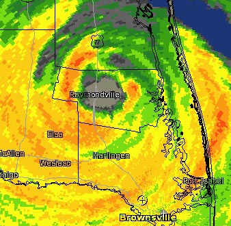
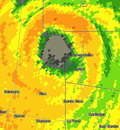
There is still an eye, finaly started moving inland.
Yeah. I just meant we haven’t had a break to go out and check stuff.
Be very careful if you do get a break in the weather.
The past several radar loops show some real westward movement. Here’s hoping Dolly marches on out of there. Enough is enough already.
The eye is directly over Raymondville and US-77 now.
And when the spare one drains, you can start your truck, switch out the batteries and let your truck charge your drained one, infinitely.
Statement as of 7:00 PM CDT on July 23, 2008
...Heavy rains and strong winds continue over south Texas...
a Hurricane Warning remains in effect for the coast of Texas from
Brownsville to just south of Baffin Bay...and for the northeastern
coast of Mexico from Rio San Fernando northward to the border
between Mexico and the United States.
A Tropical Storm Warning remains in effect from Baffin Bay
to Port O’Connor.
For storm information specific to your area...including possible
inland watches and warnings...please monitor products issued
by your local weather office.
At 700 PM CDT...0000z...the center of Hurricane Dolly was located
inland over extreme south Texas near latitude 26.6 north...longitude
98.0 west or about 60 miles...95 km...northwest of Brownsville
Texas.
Dolly is moving toward the west-northwest near 10 mph...16 km/hr.
This general motion is expected to continue tonight...taking Dolly
farther inland over south Texas. A turn to the west is expected by
late tomorrow.
Maximum sustained winds have decreased to near 75 mph...120
km/hr...with higher gusts. Dolly is a category one hurricane on
the Saffir-Simpson scale. Dolly is expected to weaken to a tropical
storm later tonight.
Hurricane force winds extend outward up to 35 miles...55 km...from
the center...and tropical storm force winds extend outward up to 140
miles...220 km.
Estimated minimum central pressure is 976 mb...28.82 inches.
Dolly is expected to produce total rainfall accumulations of 8 to 12
inches...with isolated amounts of 20 inches...over portions of
south Texas and northeastern Mexico over the next few days.
These rains will likely cause widespread flooding across portions
of south Texas and northeast Mexico.
Coastal storm surge flooding up to 6 to 8 feet above normal tide
levels...along with large and dangerous battering waves will
continue for the next few hours in areas of onshore flow but will
subside later tonight.
Isolated tornadoes are possible over portions of south Texas today
and tonight.
Repeating the 700 PM CDT position...26.6 N...98.0 W. Movement
toward...west-northwest near 10 mph. Maximum sustained winds...75
mph. Minimum central pressure...976 mb.
The next advisory will be issued by the National
Hurricane Center at 1000 PM CDT.
$$
Forecaster Franklin

Uuuuhhhhhhh, over land.
Pardon my stupidity, but I didn’t know that was possible over land. Wow!
Wow,look at that.
In other news, in delirious pleasure, the hurricane dog jumped in the pool for a swim. I guess she approves.
Heads up - upper valley, prays for everyone, on both sides.
But enough already.
I can’t believe I didn’t think about that:’)
Statement as of 10:00 PM CDT on July 23, 2008
...Dolly weakens to a tropical storm but heavy rains continue...
At 10 PM CDT...0300 UTC...all hurricane warnings along the coasts of
Texas and Mexico have been discontinued.
At 10 PM CDT...a Tropical Storm Warning is in effect from
Brownsville to Port Aransas Texas. Coastal tropical storm warnings
elsewhere are discontinued.
For storm information specific to your area...including possible
inland watches and warnings...please monitor products issued
by your local weather office.
At 1000 PM CDT...0300z...the center of Tropical Storm Dolly was
located near latitude 26.5 north...longitude 98.1 west or about 55
miles... 90 km...northwest of Brownsville Texas.
Dolly is moving toward the west near 7 mph...11 km/hr. A turn back
to the west-northwest is expected tomorrow with a slight increase
in forward speed until the system dissipates on Friday.
Maximum sustained winds are near 70 mph...110 km/hr...with higher
gusts. Dolly is expected to continue weakening as it moves further
inland...and Dolly could become a tropical depression by late
tomorrow.
Tropical storm force winds extend outward up to 115 miles...185 km
from the center.
Estimated minimum central pressure is 981 mb...28.97 inches.
Dolly is expected to produce total rainfall accumulations of 8 to 12
inches...with isolated amounts of 20 inches...over portions of
south Texas and northeastern Mexico over the next few days...causing
widespread flooding in these areas.
Coastal storm surge flooding will subside tonight.
Isolated tornadoes are possible over portions of south Texas today
and tonight.
Repeating the 1000 PM CDT position...26.5 N...98.1 W. Movement
toward...west near 7 mph. Maximum sustained winds...70 mph.
Minimum central pressure...981 mb.
An intermediate advisory will be issued by the National Hurricane
Center at 100 am CDT followed by the next complete advisory at 400
am CDT.
$$
Forecaster Franklin
Statement as of 11:00 PM EDT on July 23, 2008
the eye remains very well defined in the Brownsville radar although
it is becoming less distinct in infrared imagery. The radar is
showing some inbound velocities of up to 78 kt or so at about 2900
ft. This would normally correspond to minimal hurricane force at
the surface over water...but not over land...and Dolly is
downgraded to a tropical storm on this basis. Continued weakening
is forecast in accord with the decay SHIPS model...with Dolly
expected to dissipate over higher terrain in 36-48 hours.
The initial motion is 280/6. The large scale models show the
mid-level ridge to the north of the tropical cyclone sliding
eastward a little bit...turning Dolly back to a west-northwesterly
heading. The official forecast is close to the previous advisory
and near the middle of the guidance envelope.
Even as the winds subside...Dolly continues to produce very heavy
rains and the associated significant flooding threats will continue
for another day or two.
Forecast positions and Max winds
initial 24/0300z 26.5n 98.1w 60 kt
12hr VT 24/1200z 26.8n 99.0w 40 kt...inland
24hr VT 25/0000z 27.6n 100.8w 30 kt...inland
36hr VT 25/1200z 28.2n 103.2w 20 kt...remnant low
48hr VT 26/0000z...dissipated
$$
forecaster Franklin
Farm land. Cotton.If the farmers didn’t loose their crops 2 weeks ago I guess they are gone now.
Maximum sustained winds are near 70 mph..moving toward the
west near 7 mph...Tropical storm force winds extend outward
up to 115 miles from the center.

On/Off Hurricane List Mash Here-->
:o)
Disclaimer: Opinions posted on Free Republic are those of the individual posters and do not necessarily represent the opinion of Free Republic or its management. All materials posted herein are protected by copyright law and the exemption for fair use of copyrighted works.