Posted on 02/28/2012 7:44:29 PM PST by Theoria
Also this one:
http://frontiers-of-anthropology.blogspot.com/2012/02/american-cromagnons-archaics-and.html
This has been coming for a long time. Kennewick Man and its immediate seizure by “Native Americans” for reburial is just part of their frantic attempt to preserve the discredited theory that the first Americans were Asian peoples who crossed the Alaskan land bridge. More and more we are finding that the first Americans were from Europe. Of course, that is unacceptable to the politically correct affirmative action pimps.
Not so fast. All Europeans are "out of Africa," so "Native Americans" are really African-Americans. I get dizzy from all the politically-correct BS. Time for another cup of coffee.
"Of additional significance is the shape of the skulls, which are described as long and narrow, very unlike those of modern Native Americans."
You would likely get some argument from OTHERS about that:
Roughly 26,000 years ago, the glaciers of the Northern Hemisphere had reached their maximum size before beginning to melt — a point that scientists call the Last Glacial Maximum (LGM). At the LGM, the Earth’s ocean levels were at their lowest point and extensive reaches of dry land were exposed along the continents’ coasts.
I happened to run across something I wasn't aware of(not the first time) concerning exploration of North America's continental shelf. Dr. Adovasio(of Medowcraft fame) has been systematically SURVEYING AND SAMPLING OFF WESTERN FLORIDA since 2008. His mission -- primarily to find evidence of human occupation during the last ice age. There of course have been "accidental" discoveries on our continental shelf going back decades but he(amongst others maybe?) has apparently been able to acquire the necessary resources to do some serious exploration.
Not much but, the LATEST. BTW, don't do any "News" searches about his work. You'll find absolutely NOTHING.
Extent is easiest to measure. Weight is the most difficult ~ until we get the ground penetrating radar down tight and then we can figure that out by measuring acceleration at depth ~ dirt and rocks move aside due to the weight of the ice.
I've only seen one good one so far and that was the use of ground penetrating radar combined with other methods to take a look at the tectonic plates sitting on top the plume that provides the heat for the magma that fires up Yellowstone. Geology had that one within the last year I believe ~ kept it near the family throne room to make sure I could read it all.
Let's say Maximum ice is not all that PrecICE.
Which brings up something else ~ the archeology shows two thrusts ~ which makes sense ~ if you have Maximum Ice and giant ice flows are putting out to see you might not be able to cross the Atlantic. Both before that time and after that time you should be able to do that ~ particularly if you are adapted to eat vast amounts of seal meat.
My ancestors came here from Ireland, but I call myself
“native American” because I was born in America.
Of course this is BS too. Read Red Earth, White Lies: Native Americans and the Myth of Scientific Fact by Vine Delora.
ML/NJ
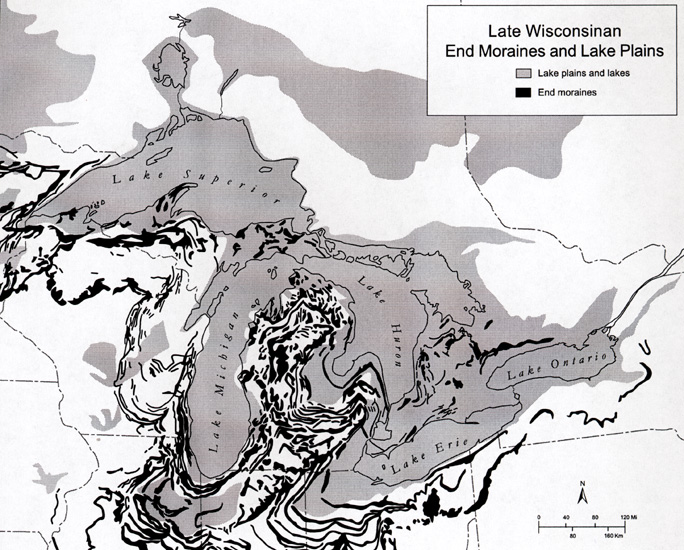
I don't know it you've ever looked closely at a shaded relief map of America del Norte or not, but in particular around the southern edges of the Great Lakes you'll find what appear to be numerous "terminal" moraines. That would indicate to me that most likely the ice sheets' "flows" became smaller and smaller as they gradually retreated in fits and spurts overall. Maybe not but that's the way it looks to me...
Each time the lake dropped you got a new beach, and additional indentations in the very large terminal moraines at the margins.
BTW, Lake Erie's last big drop was only 4,000 years ago. Virtually NO American Indian settlements were built in the muck area left behind that extended from Ohio through North Central Indiana. That area is still drying out!
Most of the big changes we can see today are a consequence of the movement of water, not ice. The Ice was mostly gone 14,000 years ago but came back in the Younger Dryas ~ which is a totally separate topic ~ but that happened AFTER humans had started moving to America, and may well have wiped almost all of them out ~
Br'r Delora has a different agenda than science.
The fact he wants to lift the blame from Indians for wiping out the megafauna means he hasn't got a good grasp on the situation.
Fact is the Younger Dryas probably killed the megafauna. First the ice melted and vast grasslands filled in South of the melt. The megafauna moved North to eat the new grass and escape the encroaching forest lands. The big cats went with them.
Then, one day, the Younger Dryas happened in a flash, and the ice age conditions came back instantly.
The megafauna could not flee South fast enough and they and the cats that lived on them ALL FROZE TO DEATH if they didn't simply starve.
The greater part of the ancestry of the American Indians came here only 5,000 years ago ~ the megafauna had been dead for 6,000 years by then!
That's why the Indians aren't guilty.
BTW, I've got a huge version of this map on my computer for the whole of North America; all 54Meg of it that I can't locate on the web any more...
This is windblown sand ~ the City of Chicago is built on top of massive dunes pushed over into the lake. Indiana's dunes are still mostly there, and there are some large ones in Michigan too.
South of the dunes it's REALLY FLAT ~ and I mean flat ~ like lake bottom.
I took a look on Google.earth to see what it was your pictures showed, and that's THE DUNES.
Try this: http://www.msue.msu.edu/objects/content_revision/download.cfm/item_id.211898/workspace_id.26697/How%20The%20Great%20Lakes%20Were%20Formed%20(Video).swf/
Michigan has sleeping Bear Dunes....state park...I climbed those things with my 5 kids. They got to the top fast and the older one’s came down and dragged their poor mother up to the top as a couple disappeared over the top of the dunes and I was afraid I’d lose them....they were the younger 3...climbing dunes sucks......GG that was about 44 years ago..
Because the glaciers are so devastatingly huge little is left behind from earlier glacial periods ~ most of what we see is pretty recent. The Great Lakes are, so far, believed to be of recent origin. HOWEVER, there are all sorts of volcanic vents throughout the Midwest that are buried with dirt pushed in by the glaciers. Most people don't know they are there unless they happen to tap in for free heat and hot water. One large vent is actually at the East End of Lake Superior!
Beneath all of that is a mountain range entombed in vast shale and limestone deposits ~ and compounding that are a couple of major faults ~ one 17 miles deep under the route of the Mississippi, and other less deep called the Carmel Fault which runs through Southern Indiana to roughly Indianapolis/Carmel.
These features are left over from a time when the proto-North American continent was splitting in two ~ like the Afars region and the Great Rift Valley in Africa.
In between there are oil bearing shales, and even a range of shale running about 150 miles North to South bisecting Indiana, and underlying the region about 20 miles wide ~ and it has vast but currently untapped uranium deposits.
This region could eventually be put to use providing America all the energy it will ever need.
Some of the moraines in Northern Indiana and Ohio are flat out invisible to all but the most practiced eye.
So, basically, the current grief mongers and dispensation demanders are the descendants of those who drove my own ancestors out of our adopted “native land” of north America?
I demand reparations.
The interest on a debt that is tens of thousands of years old must be massive. I want my own personal casino as repayment!
The Solutrean hypothesis builds on similarities between the Solutrean industry and the later Clovis culture / Clovis points of North America, and suggests that people with Solutrean tool-technology crossed the Ice Age Atlantic by moving along the pack ice edge, using survival skills similar to that of modern Eskimo people. The migrants arrived in northeastern North America and served as the donor culture for what eventually developed into Clovis tool-making technology.
Archaeologists Dennis Stanford and Bruce Bradley suggest that the Clovis point derived from the points of the Solutrean culture of southern France (19,000BP) through the Cactus Hill points of Virginia (16,000BP) to the Clovis point.[1][2] This would mean that people would have had to move from the Bay of Biscay across the edge of the Atlantic ice sheet to North America. Supporters of this hypothesis believe it would have been feasible using traditional Eskimo techniques still in use today,[1] while others argue that the conditions at the time would not have made such a journey likely.[3]
Thanks wildbill!
Disclaimer: Opinions posted on Free Republic are those of the individual posters and do not necessarily represent the opinion of Free Republic or its management. All materials posted herein are protected by copyright law and the exemption for fair use of copyrighted works.