Posted on 07/20/2013 10:39:45 PM PDT by blam
Edited on 07/20/2013 11:00:25 PM PDT by Admin Moderator. [history]
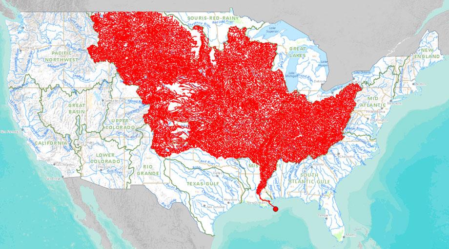
A new online tool released by the Department of the Interior this week allows users to select any major stream and trace it up to its sources or down to its watershed.
The above map, exported from the tool, highlights all the major tributaries that feed into the Mississippi River, illustrating the river
(Excerpt) Read more at slate.com ...
Looks fantastic. I’d hate to have to marinade all that.
OK, that as definitely posted on the wrong thread.
Because of this, The lower Mississippi will never flood solely because of flooding on the upper Mississippi/Missouri, no matter how bad.
The "mighty Mississippi" is mighty only because of the Ohio River.
The water flow of the Amazon is greater than the next ten largest rivers in the world combined. It it the second longest because the Nile just barely beats it in length.
Water! I like water...
When I was a kid there was an old guy in town that something happened to his mother and he ended up going to sea with his dad when he was nine years old. There was no Panama canal then. He said the sailing ships could take on fresh water 200 miles out off of the Amazon river. That is some current. He was a pretty neat old guy. Had some great stories.
I love that map. Zoo animals come from here. LOL!
This Mississippi is improperly named. It starts in Minnisota where it flows into the Missouri at St Louis. The Missouri is the dominant river, and it is the Missouri that flows from way out west...
The Missouri River is the longest river in North America,[11] longest tributary in the United States and a major waterway of the central United States. Rising in the Rocky Mountains of western Montana, the Missouri flows east and south for 2,341 miles (3,767 km)[7] before entering the Mississippi River north of St. Louis, Missouri. The river takes drainage from a sparsely populated, semi-arid watershed of more than half a million square miles (1,300,000 km2), which includes parts of ten U.S. states and two Canadian provinces. When combined with the lower Mississippi River, it forms the world’s third longest river system.
For over 12,000 years, people have depended on the Missouri and its tributaries as a source of sustenance and transportation. More than ten major groups of Native Americans populated the watershed, most leading a nomadic lifestyle and dependent on enormous buffalo herds that once roamed through the Great Plains. The first Europeans encountered the river in the late seventeenth century, and the region passed through Spanish and French hands before finally becoming part of the United States through the Louisiana Purchase. The Missouri was long believed to be part of the Northwest Passage – a water route from the Atlantic to the Pacific – but when Lewis and Clark became the first to travel the river’s entire length, they confirmed the mythical pathway to be no more than a legend.
Very cute...:-)
I like stories like this too. 200 hundred miles out, amazing. That has to have some effect on fishing?
Yes, the Amazon is a river’s river. If I recall my geography correctly, it is 60 miles wide at its mouth and affects weather and salinity 100 miles out to sea. Its drainage area is huge and gets a lot of rainfall because the area is tropical and the Andes “squeeze” most of the moisture out of the air when it is forced upward.
See my post #44.
Your map sums it up I think.
Thanks blam, one of my kids is testing stream water this summer as part of her internship.
Disclaimer: Opinions posted on Free Republic are those of the individual posters and do not necessarily represent the opinion of Free Republic or its management. All materials posted herein are protected by copyright law and the exemption for fair use of copyrighted works.