Skip to comments.
Astronomy Picture of the Day -- Curiosity Inspects Mt. Remarkable on Mars
NASA ^
| May 07, 2014
| (see photo credit)
Posted on 05/07/2014 4:40:09 PM PDT by SunkenCiv
click here to read article
Navigation: use the links below to view more comments.
first previous 1-20, 21-40, 41-42 next last
To: SunkenCiv
Nothing there now. Time to terraform and colonize.
21
posted on
05/07/2014 6:03:20 PM PDT
by
Dallas59
("Remember me as you pass by, As you are now, so once was I, As I am now, so you will be")
To: The Cajun
Are you sure they didn’t take a closer look?
22
posted on
05/07/2014 6:17:16 PM PDT
by
Nuc 1.1
(Nuc 1 Liberals aren't Patriots. Remember 1789!)
To: SunkenCiv
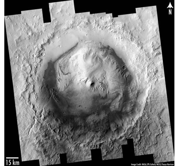
Mt. Sharp, the unusual central peak of Gale Crater, has a similar base-to-peak height as Earth's Mt. Everest.Very misleading, I would say. What they've been calling Mount Sharp is not the small central peak you see at the center of this comparison, but the entire central area of the crater, ringed by the dark dunes. Curiosity is at the top left, traversing westward along that north side of that thin, straight, dark strip towards the "lower slopes" of Mount Sharp.
The yellow line in the Mt. Everest ( in the blue circle ) comparison is 15 km.
23
posted on
05/07/2014 6:46:09 PM PDT
by
dr_lew
To: The Cajun
I am an avid student of the Curiosity image gallery, but I can’t locate anything resembling this “pipe” formation in the Mastcam gallery for sol 51 or sol 64. It is hard to look for, though, if you don’t know the scale. They can’t be very severe blowups, though, since the resolution is high, but has it’s limits.
You don’t happen to know any raw image numbers, do you? I looked at the Enterprise Mission website, but it just gives the sol numbers.
24
posted on
05/07/2014 7:50:00 PM PDT
by
dr_lew
To: SunkenCiv
Awesome pic!!!
At times, Mars reminds me a great deal of Tattooine.
25
posted on
05/07/2014 8:09:05 PM PDT
by
KoRn
(Department of Homeland Security, Certified - "Right Wing Extremist")
To: dr_lew
This NASA-Curiosity image was taken several hundred feet east of the initial “Bradbury Landing” site, as the rover was driving toward a region called “Glenelg.”
The object is called the *Glenelg Pump".
Below is the raw JPL photo:

The address for the photo is:
http://mars.jpl.nasa.gov/msl-raw-images/msss/00064/mcam/0064MR0285005000E1_DXXX.jpg#sthash.DylocVqc.dpuf
I have no idea of the scaling or distances involved, I just find it interesting.
26
posted on
05/07/2014 8:55:21 PM PDT
by
The Cajun
(tea party!!!, Sarah Palin, Mark Levin, Ted Cruz, Mike Lee, Louie Gohmert......Nuff said.)
To: The Cajun
OK thanks! I was looking through these and I don’t know how I missed it, as it’s very clear. Notice that it is actually partly obscured by that ledge, so that the left profile is between the lighter ledge and the darker object.
I’m gonna say it’s about 20 ft. away. The mastcam is about 6 ft up, so it gives something like a human eye level view. From my “studies” I have noted that the areas in view are usually smaller than you tend to make them out to be.
Anyway, I’m going to look at it some more. So thanks again.
27
posted on
05/07/2014 9:27:44 PM PDT
by
dr_lew
To: SunkenCiv
Why the fudged color scheme?
Look at the rover at the bottom left. Photoshopped color!
28
posted on
05/08/2014 12:42:09 AM PDT
by
rawcatslyentist
(Jeremiah 50:32 "The arrogant one will stumble and fall ; / ?)
To: rawcatslyentist
The rovers carry a color reference plate to enable NASA to “fix it in post”.
29
posted on
05/08/2014 3:38:43 PM PDT
by
SunkenCiv
(https://secure.freerepublic.com/donate/)
To: The Cajun
Weird, but how big is it?
30
posted on
05/08/2014 3:40:26 PM PDT
by
GeronL
(Vote for Conservatives not for Republicans!)
To: dr_lew
Thanks dr_lew. Vulcanologists had everyone convinced that impact craters on the Earth and Moon were actually volcanic in origin. The impact origin of Earth’s craters was proved out in the 1950s, but the alleged volcanic origin of lunar craters persisted until the Apollo surface missions showed that there’s almost nothing *but* impact at work on the lunar surface. Before Apollo the US got a set of flyby photos of Mars (the probe was supposed to go into orbital capture, but they missed) showing the cratered surface, and so the volcanic origin of Martian craters was proposed, rejected, proposed, rejected, and it’s on an uptick. There may have been some secondary vulcanism here, but Mt Sharp is clearly an impact structure, imho.
31
posted on
05/08/2014 3:43:57 PM PDT
by
SunkenCiv
(https://secure.freerepublic.com/donate/)
To: KoRn
32
posted on
05/08/2014 3:44:25 PM PDT
by
SunkenCiv
(https://secure.freerepublic.com/donate/)
To: Dallas59
That’ll be difficult at best. As a long term project, Mars colonies would have to be under domes, but the domes could be constructed out of asteroidal material and dropped down to the surface (thud!), then the work crews would arrive, burrow under the edge, and install the large airlock(s), then fill the domes with Earthlike atmospheres.
33
posted on
05/08/2014 3:46:50 PM PDT
by
SunkenCiv
(https://secure.freerepublic.com/donate/)
To: cripplecreek
On a side note, I always laugh during “Apollo 13” when the Jim character gets to the “Mount Marilyn” line.
34
posted on
05/08/2014 3:49:12 PM PDT
by
SunkenCiv
(https://secure.freerepublic.com/donate/)
To: cripplecreek
35
posted on
05/08/2014 3:51:13 PM PDT
by
SunkenCiv
(https://secure.freerepublic.com/donate/)
To: TheOldLady; The Cajun
36
posted on
05/08/2014 3:57:37 PM PDT
by
SunkenCiv
(https://secure.freerepublic.com/donate/)
To: SunkenCiv
Its actually working pretty good now aside from the fact that its in the dark for about 40 minutes on and off.
37
posted on
05/08/2014 4:00:23 PM PDT
by
cripplecreek
(Remember the River Raisin.)
To: SunkenCiv
Mt Sharp appears to be constructed of layered sediment. Gale Crater itself is over a billion years old, I believe, and one school of thought has it that the whole crater, even above the rim, was filled with sediment due to water flooding, and this was part of the thinking that made it a landing site of interest, since the sediments could have been submarine for many millions of years according to this idea.
There were doubters, and an alternative theory is that Mt Sharp accumulated in place as a result of Aeolian transport. I think there was a recent study that concluded that the layers “sag” around the edges, in support of the Aeolian hypothesis.
38
posted on
05/08/2014 4:00:38 PM PDT
by
dr_lew
To: SunkenCiv
39
posted on
05/08/2014 4:26:08 PM PDT
by
cripplecreek
(Remember the River Raisin.)
To: SunkenCiv
Thank you, Mr. Civilizations.
Navigation: use the links below to view more comments.
first previous 1-20, 21-40, 41-42 next last
Disclaimer:
Opinions posted on Free Republic are those of the individual
posters and do not necessarily represent the opinion of Free Republic or its
management. All materials posted herein are protected by copyright law and the
exemption for fair use of copyrighted works.
FreeRepublic.com is powered by software copyright 2000-2008 John Robinson
