Posted on 08/22/2004 9:53:14 AM PDT by Willie Green
In the summer of 1755, soldiers faced heat, disease and enemies as they marched across a quarter of the American continent to do battle.
That summer, some 2,400 French and Indian War troops under the command of British Gen. Edward Braddock walked from Virginia to stage what turned out to be a botched assault on the Point in Pittsburgh, the key to westward expansion and in the firm grip of the French and their Indian allies in the 1750s.
"These were tough people," mused tourist Douglas Roach, as he rested on a bench next to Braddock's Grave along Route 40 in Fayette County.
Roach, a descendant of Connellsville's 18th-century surveyor-explorer-soldier William Crawford, moments earlier paused before Braddock's original resting place after he was fatally wounded at the Battle of the Monongahela, in the middle of the forest path named in his honor, Braddock's Road.
"I knew that's where he had been," said Roach, who had traveled from his home in Maine. "I knew they had rolled the wagons over the grave. It was a common practice, not unusual at all. To keep the Indians away. To disguise it."
Several years ago, the National Park Service re-engineered the area around Braddock's grave. The agency erected new signs explaining the British expedition against Fort Duquesne, paved a parking lot and built steps leading to what historian-preservationists call a "trace" of the 249- year-old road, a cleared path that angles slightly downhill about 100 feet from Braddock's next to final resting place.
First-time visitors often are startled to discover signs of the 1750s road and traces of the grave site -- signs that the French and Indian War was a real event with bloody consequences.
(Excerpt) Read more at pittsburghlive.com ...
ping
|
|
|||
Gods |
Note: this topic is from 2004. |
||
|
· Discover · Nat Geographic · Texas AM Anthro News · Yahoo Anthro & Archaeo · Google · · The Archaeology Channel · Excerpt, or Link only? · cgk's list of ping lists · |
|||
An unintentional, but effective, slam of public education.
:’)
Braddock's Road followed Eagle Street in Mt. Pleasant, passing through what is now Frick Hospital and the former Ramsay High School building. Following the ridge, it exited the town through the Mt. Pleasant Cemetery.
Wow, that certainly is a blast from the past.
But I'm sorry to see that there wasn't much interest when I originally posted it.
But then again, I grew up in this area and always had an interest in this chapter of our history.
This cemetary is where my grandparents are buried and the HS is where my parents went.
And we had other family who lived on Eagle St.
Until I was 4-years-old, our house was on the other side of town, but there was an old, overgrown cemetary in the field in back of it.
It actually wasn't much of a cemetary. As I vaguely recall, it was just a couple of marked graves rumored to be from the Braddock period. I can remember Dad clearing away some of the weeds and brush when he took me back there once to see it.
But we move to the 'Burgh when I was older, so I can't pass along the lore as well as if I had actually grown up there.
Thanks. I wonder if the cemetery has basically vanished, or has been carefully restored and maintained since that time?
Traces of the road can be found in the forests east of Fort Necessity, along the southern edge of Route 40. Where the land has been farmed, the trail has been pretty much wiped out...
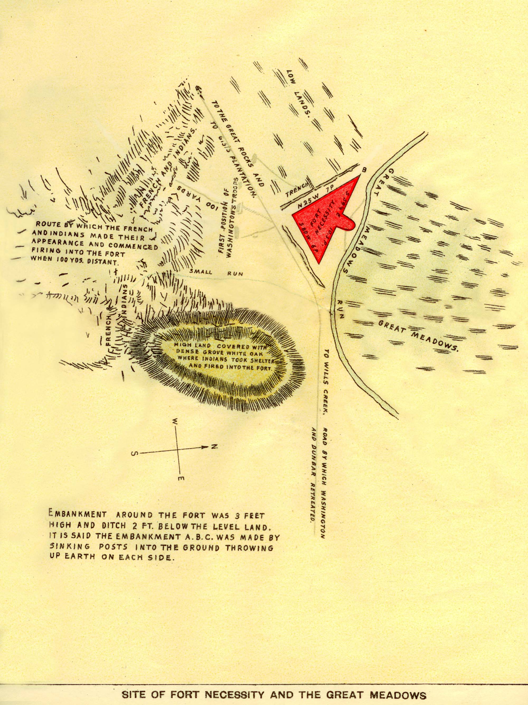
The following is from Evert's History of Fayette county and refers to the locality as it was about 1881 :
"Mr. Facenbaker, the present occupant, came to the property in 1856, and cut a ditch, straightening the windings of the run, and consequently destroying the outline. The ditch is outside the base-line, through the out-thrown two perches. A lane runs through the southeast angle. The ruins of the fort or embanked stockade, which it really was, is three hundred yards south of Facenbaker's residence, or the Mount Washington stand, in a meadow, on waters of Great Meadow Run, a tributary of the Youghiogheny. On the north, two hundred yards distant from the works, was wooded upland; on the northwest a regular slope to high ground about four hundred yards away, now cleared, then woods; on the south about two hundred and fifty yards to the top of a hill, now cleared, then woods, divided by a small spring run breaking from a hill on the southeast, eighty yards away, then heavily, and still partially, wooded. A cherry tree stands on one line and two crab-apples on the other. The base is scarcely visible, with all trace gone of line across the run. Mr. Geoffrey Facenbaker says he cleared up a locust thicket there and left a few trees standing, and that it was the richest spot on the farm. About four hundred yards below, in a thicket close to his lower barn, several ridges of stone were thrown up, and here he thinks the Indians buried their dead. He found in the lane in ditching, logs five feet under ground in good preservation."
"The site of the fort has not been desecrated by the plow since it came into the possession of the Facenbaker family. Mr. Lewis Facenbaker is the present owner."
The location is in Wharton township, Fayette county.
Thanks FN.
But I just used Mapquest aerial maps to look at the field in back of my old house where the old graves were and got a helluva shock. The last time I looked at the old family homestead (maybe a year or two ago?) it was still basicly the same as it was 50+ years ago when I was a little tyke. But now it looks like they tore down the neighbor house and put in a road that runs right parallel along our old driveway through what used to be the neighbors yard. So in the back, it continues right along the old farmer's treeline where there was an overgrown dirt road (farmer's access to the field for his tractor?) that led back to the couple of graves I was talking about.
So right now, I'm PRAYING that somebody discovered those old graves when they put in that road and relocated them with some dignity.
Oh, my 81-year-old Mom just confirmed my vague childhood memories that there were a couple of graves back there in the woods. But it's gonna take a while before I can get her to look at the Mapquest aerial map to take a closer look. (She probably won't remember that detail anyway. It was Dad who took me on the hike back in the woods to see the graves. Mom wasn't in to that sort of thing.)
Wow, terrible.
I thought I knew most of Braddock but I never heard of the area you are talking about. Where is it in relationship to the High School or the old Administrative Bldg. (that is now a private home)?
On another subject but related, a few years back my U-18 soccer team was playing a tournament in Virginia. To my surprise one of our games we were playing a team called Braddock Road. After the game I met several parents and found out there is a town in Virginia called Braddock Road. I have no clue how it got its name.
I wasn't talking about Braddock, although maybe that's mentioned in the article too.
I'm talking about the portion of Braddock Road that passes through Mount Pleasant in Westmoreland County (close to Greensburg and New Stanton... that area) That's the little town my family is originally from, before we moved to the 'Burgh when I was 4-years-old.
It's basicly the original path that General Braddock blazed through the woods when George Washington was just a young surveyor, and they built Fort Necessity an at... LOL! I know I just butchered the history, but you know what I mean.
;^)
Disclaimer: Opinions posted on Free Republic are those of the individual posters and do not necessarily represent the opinion of Free Republic or its management. All materials posted herein are protected by copyright law and the exemption for fair use of copyrighted works.