That's good to know, I'll keep it in the "possible" drawer for future reference.
I'm not sure I got this across in the main text, and it leads to something I left out, so...
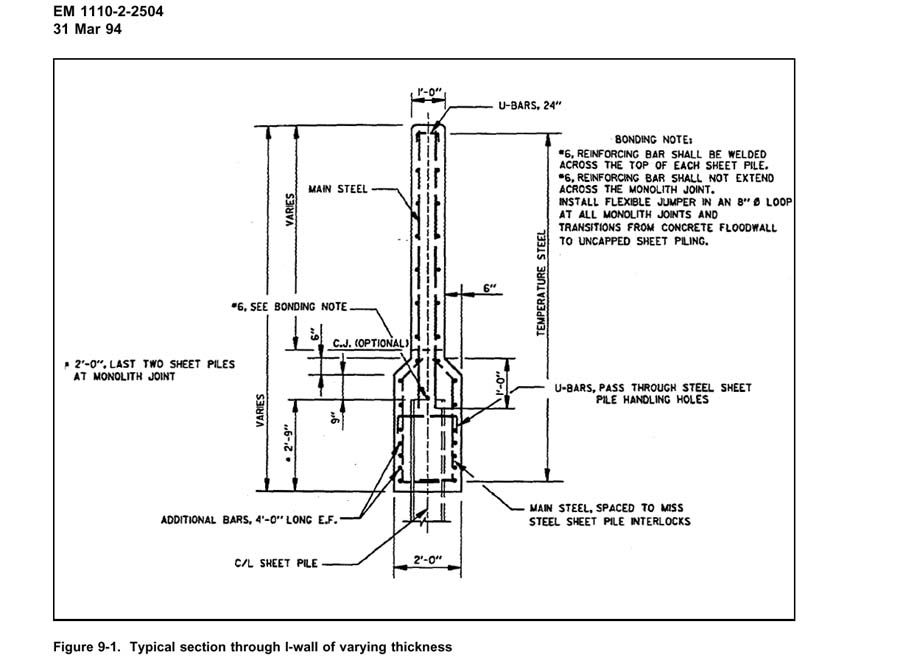
Here's a pile of dirt, 700 feet long, 30 to 50 feet thick, the old levee embankment. On top of it is a concrete wall, eyeball says 10 feet tall, and the specs say 2 feet thick at the base, 1 foot thick at the top, each lineal foot of capwall weighing about, oh, twelve lineal feet of concrete sidewalk, a LOT of weight.
We know it failed, which means that the water pressure at some point exceeded the I-Wall's resistance to lateral displacement, which further means that at some earlier point the opposing forces exactly balanced.
Ever drive around a curve on ice and feel your car go "up on her toes" on the edge of a skid?
Seven hundred feet of heavy earthen embankment and concrete was balanced like that, essentially resting on ball bearings, before it failed. Because we know the weak layer was extensive, probably orders of magnitude more levee was in that perfectly balanced condition or very close to it at some point during the storm's passage.
Not to scare you, because any breach wider than the width of the canal where it connects to the Lake will not speed the flooding of the city up by much, whether it's a foot wider than the canal outlet, or a mile wider than the canal outlet. A wider breach will drain the canal faster, but then the limiting factor becomes the narrowest point in the canal between Lake and breach.
Anyway, the point here is, while large sections of levee were in such a precarious position, just about anything coud have caused a breach. A disruption from a felled tree's root ball thirty years ago in the embankment, one nutria tunnel, one shingle blown off a neighboring house and hitting the levee at 85 mph might have done it. A non-compliant swimming pool excavation could be akin to a speeding locomotive broadsiding your car on the icy curve by comparison. Yes, that would certainly do the trick.
While the 17th Street Canal breach is under discussion, the subject of the old court case involving the contractor who claimed weak soil needs to be addressed. MSNBC linked to an online version of the judge's decision in that case, but plastered their logo all over it so you couldn't read it.
That wasn't an accident. They didn't want you to read it because it blew their whole story line out of the water. The best laid plans, however...
If you really want to read it, you need to download the PDF file, open it, and open an image browser. Flip to page 2, hold your finger over the "Prtscrn" (Print screen) key on your keyboard, flip back to page 1, and hit Printscreen before the NBC logo loads, it is the last layer to be rendered. Then just go to your image browser, open a New image, paste the clipboard contents to the image, zoom to 100% and read what they never wanted you to read.
The judge's decision clearly demonstrates that this case involved a less than competent contractor trying to scam his way out of a jam.
Basically, he failed to brace his concrete forms properly, and the wet concrete pushed them around, and the wall sections set-up ("dried" to most people) crooked.
When the Corps of Engineers called him on it, he said the CoE had misrepresented conditions at the worksite. The CoE said to state their case in writing, make an official report describing what the contractor was claiming the CoE said about the worksite that turned out not to be true.
The contractor took a very long time responding to that request, basically giving the CoE the report shortly before the case went to court.
The contractor claimed that the CoE misrepresented the strength of the soil.
The CoE replied, "How would you know? You never bothered to request our soil testing data before submitting a bid. All the OTHER companies did. In fact, you never requested the data at all until your concrete went crooked due to sloppy form bracing and we called you on it."
At that point the contractor claimed that weak soil allowed the form brace anchors to wobble.
The CoE's response was that it was poor construction practice to try and brace forms to support heavy wet concrete on anchors driven only six feet in the ground, and that further, the CoE had no say in bracing techniques, that responsibility for bracing was explicitly assigned to the contractor in the standard contract that he had signed, and that finally, another contractor nearby had performed flawless work under the same conditions.
The judge was not amused, the contractor did NOT win the case, the contractor later went bankrupt, and NBC plastered their logo all over the "supporting documents" for their story because they didn't want you to read those documents, because then you would know that their whole "CoE Warned About Weak Soil Long Before Katrina" storyline was a pile of nutria squat.
An unproven....no....actually a disproven claim of "weak soil" at six feet below grade, has exactly zero bearing on a demonstrated weak layer at 15 to 20 feet below grade.
All it accomplishes is to demonstrate how far NBC is willing to go to pin the blame anywhere besides where it actually belongs.
Levee Assessment Update 1
1. ASCE Preliminary Report, Conclusion Similarities and Dissimilarities
2. Non-Compliant Swimming Pool at 17th Street Canal Breach?
3. New Orleans Soil and Levee Viability
4. Feds Open Criminal Probe into Levee Failures
1. American Society of Civil Engineers Preliminary Report
The ASCE has issued a preliminary report including their preliminary findings and data resulting from their investigations. It can be found here.
ACSE Preliminary Report
One of the primary authors also testified before the Senate Katrina Investigation Committee, his testimony is available here.
Seed Testimony
I find it interesting that several news articles reference this report and testimony along with claims that the levees were not built to design specifications, and that construction "malfeasance" was a factor in the levee failures, when neither the testimony , nor the report contain substantiating evidence supporting either claim. It is too early to tell if such evidence exists, or if these reports are based in political maneuver on the part of either authors, the reporting agency, or both.
The ASCE Preliminary Report agrees with many of the conclusions reached in the Levee Failure Analysis heading this thread, including:
1. Direct failure mechanism in the 17th Street and London Canal breaches.
2. Minimal funneling effect at the MRGO Intercoastal Waterway junction.
3. Minimal topping and breaching along the Intercoastal Waterway.
4. Significant breaching and resultant flooding near the Lakeview Airport in northwest east Orleans Parish.
The two reports begin to diverge on the subject of breaching which occurred at levee transitions. Although the ASCE report does bring to light a few additional legitimate cases of breaching at transitions, such as the breach at the southwest corner of the main Industrial Canal Basin, and the breach near the Lakeview Airport, they discuss nowhere enough of them to substantiate media claims that "most" or even "many" of the tens or hundreds of breaches occurred in this manner.
Additionally, they include at least three breaches in this category which is not supported by the empirical evidence presented. In one instance they include a photo of a sundered sheetpile curtain along the north boundary of the Intercoastal Waterway which does represent transitions, in that the sheet pile curtain blocks an opening in the typical levee along that section, but the failure as shown is entirely limited to the sheetpile failure itself, not the different construction design on either side of it.
In another instance, they present a breach immediately south of the Bienvenue Floodgate as being a transitional breach, which it is, but the US Army Corps of Engineers has claimed that this was a deliberate breach made to allow floodwaters to flow out of the habitated areas.
In a third discussion, the ASCE report labels evidence of topping south and west of the I-10 bridge over the Industrial Canal a breach, and claims it to be transition related, when in fact, this area was more likely subject to a massive standing wave spilling sideways, and the "transition" is where additional protection from a roadway and rail embankment most likely prevented a full breach.
While the Preliminary Report does make a good case for closer inspection at, and probable design improvements at levee transitions, it falls significantly short of earlier media claims that breaching at transitions was the primary cause for the flooding of the city.
Finally, the ASCE report addresses neither of the two most important conclusions or possibilities raised and discussed in the Failure Assessment:
1. Convincing correlation between full and partial breaches on the MRGO and known incidents of pre-storm subsidence, raising significant concerns regarding past, present and future levee maintenence responsibilities.
2. The possibility that bridge related hydrodynamic laminar or turbulent stormsurge flow was responsible for the locations of the Canal levee failures. In fact, the ASCE Preliminary Report unknowingly further substantiates this possibility, in providing evidence of a near breach in the distressed section of the levee directly across the canal from the northern London Canal breach. Out of now four known breaches or near breaches in New Orleans Canal Levee system, all four are in close proximity to bridge structures. Without processor intensive modelling of the flows around these bridges, it is impossible to know the effects, if any, that piers, abutments or foundation structures may have on adjoining levee sections.
2. Non-compliant Swimming Pool at 17th Street Canal Breach
An FR member raised an interesting theory in an earlier post, that a non-compliant swimming pool may have contributed to the I-wall failure on the 17th Canal protective system.
The following image indicates potential substantiation of this theory:
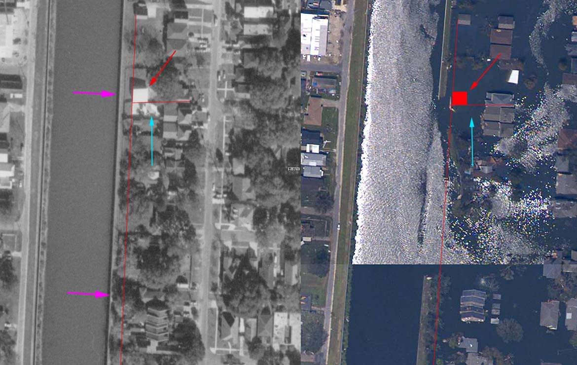
The above image is a mosaic of two photographs, the left pane being a pre-storm overhead image obtained from Terraserver, and the right pane being a post-Katrina overhead image obtained from NOAA.
The violet arrows in the left pane indicate the extent of the levee breach, the red arrow in both panes indicates a structure which may be a screened swimming pool enclosure, and the blue arrow in both panes indicates what appears to be a free-form swimming pool in the pre-storm image.
The coincidence between the location of these two possible structures and the northern end of the 17th Street Canal breach mandates further investigation into this claim. As discussed earlier, with much of the Canal levee system resting on known weak soil, and with storm surge related forces in equilibrium with the levee system's ability to resist lateral displacement, very little would be required to tip the scales and result in breaching. The following image raises questions regarding this possibility, however:
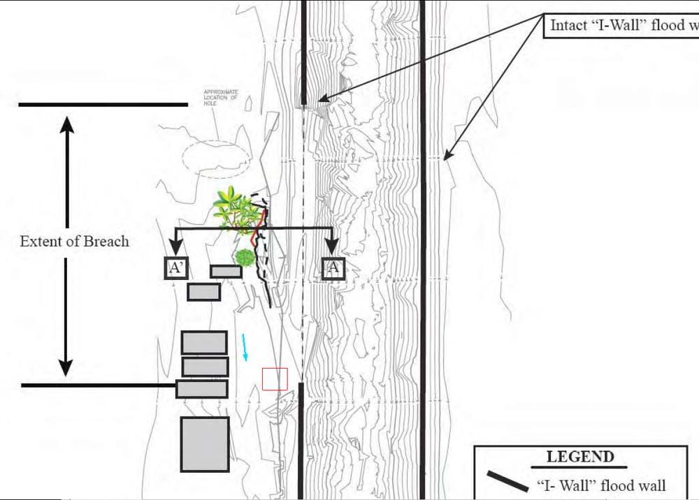
This image was obtained from the ASCE Preliminary Report, and show the results of LIDAR (Light Detection and Ranging, similar to radar except using coherent light from a laser as the probe) mapping of the area near the 17th Street Canal Breach. Note that this image is inverted, in relation to the previous mosaic, in this image, north is "down".
The approximate location of the possible pool enclosure and the possible free-form in ground pool are noted here using the same conventions noted above. The LIDAR map does not show topgraphic depressions in the area of either possible swimming pool. The LIDAR map does show, however, a deep scour near the southern end of the breach, what I would normally expect to find where the surge flow current was strongest and most prolonged. There is no visible evidence in the pre-storm imagery that corresponds with this scour at the southern extent of the Canal breach.
This is not conclusive, however, as the flow regime may well have been dynamic with respect to time, and may have resulted in scour deposits over and in both possible pool structures, filling and covering them.
Clearly, the interests of all concerned would be served by further research into this theory. Thanks to FReeper mom4kittys for the initial heads-up.
3. New Orleans Soil and Levee Viability
Numerous media reports, Legislators and Free Reopublic members have raised questions as to the long term viability of a levee system protecting New Orleans or any other city from flooding in a location lower than mean sea level.
There is absolutely no doubt that we can protect New Orleans, or any other similarly located city. The Dutch have protected their land, and more significantly, we have and continue to place men into earth orbit and on the surface of the moon in spite of conditions much more severe than anything a few feet or water can be expected to produce.
The technology exists, we can protect the city, but we can do a lot of things, solely because we can is not a compelling reason why we should. This issue comes to the very heart of my disquiet with ongoing processes involving the rebuilding of New Orleans. Were my opinion law, this entire effort would proceed as follows:
1. Preserve options. If we decide to rebuild New Orleans, there's no sense in saving a few millions of dollars now if it requires us to spend billions or more later on. Right now the focus should be on efficiently and economically saving and salvaging what we can, to prevent any further deterioration and loss, while the decision making process continues.
2. A cost/benefit/risk analysis should already be underway. We have a good idea how often similar hurricanes strike this area, we know generally what it will cost to protect against them at different levels of storm protection, we have a long history to study regarding the benefits of the city of New Orlean's size and location, the fact of this study should be a no-brainer, but as far as I'm aware, it hasn't even been suggested yet. To me, this is the fundamental first step in the rebuilding process. Without this study and conclusions derived there-from, we cannot begin to approach the rebuilding process with anything at all approaching foresight. With the results in hand, however, we would be in a position to evolve a global plan to approach the enormous task at hand, phase by phase and step by step capable of re-creating and improving what we have lost.
3. When I hire someone to manage a construction site for me, I expect them to manage certain issues on their own. I also expect them to consult with me if larger issues crop up, and I expect a competent manager to know when to decide for himself and when to consult with me. The same principle applies to government officials. Once the cost/benefit/risk data is obtained, I believe that the American people deserve a referendum to decide the best way to proceed from here. I do not believe that our elected government is empowered to decide questions of this magnitude without our input. The potential consequences are enormous, either way.
New Orleans represents significant National Infrastructure, one of our busiest ports, a nexus for scarce energy transit, several Universities, many of which have active and productive research programs, an unflooded nuclear plant, several airports, bridges, highways, water and snaitary systems, electrical grid, numerous high rise and commercial structures, a great historical wealth, and overall, an enormous integrated physical plant, once fully functional, requiring two hundred years to design, construct and improve, and you just do not walk away from the economic treasure an entire city represents without a depth of consideration.
On the other hand, there are numerous obstacles in trying to preseve the city as it once was. Its location is both exposed and subject to additional storms, and also the soils there are not ideal for constructing a safe haven. Even applying our best and brightest solutions, and all the funding we can afford, there is no guarantee of a return on the investment. In constructing protection against a category 5 storm, a stronger storm could occur, and mistakes now or later, not to mention malfeasance at any time, we could potentially lose our investment yet again.
Given that the American people will fund whatever decision is made, we should have the majority voice in the decision making process. One of the deciding issues for me is that I believe it is mathematically impossible to rebuild the city is such a way as to preserve our investment, with the current state and local leadership in place. By no process of interpolation or extrapolation can I find the variables requisite for success. Long term past history and current events up to date mandate a change in the governing powers there for any reconstruction process to enjoy even a chance of success.
4. It is a fundamental right in America to choose one's future for one's self. If the American general population turns out to be unconvinced that rebuilding the city is our best course, there should be no obstacles to others who believe differently striking out on their own. Even if we believe this isn't the best choice, if they wish to take and shoulder their own risks, and we try to stop them, then a vital part of the American spirit has been lost. I haven't decided what is best yet, because I believe that to do so without the cost/benefit/risk analysis results, would be irresponsible, regardless of which way the decision turned. But if the national consensus, based on the best data and analysis possible is "No", and former residents or anyone else chooses to go it alone, then not only do they deserve that chance, they also deserve any and all benefits and consequences resulting from their decision.
4.
Federal Officials Open Criminal Probe into Levee Failures
"NEW ORLEANS
Federal prosecutors are conducting a criminal investigation into the levee failures that swamped New Orleans, looking into the possibility of corruption in the design, construction and maintenance of the flood barriers.
U.S. Attorney Jim Letten said Wednesday that his office began the investigation the week after Hurricane Katrina.
"The scope of our interest is very broad," he said. He said some officials were found to have undisclosed conflicts of interest, and "we're extremely concerned about those." He would not give details.
James Bernazzani, FBI agent in charge in New Orleans, said agents have received numerous tips about possible malfeasance."
Excerpt, more at: