To: TXnMA
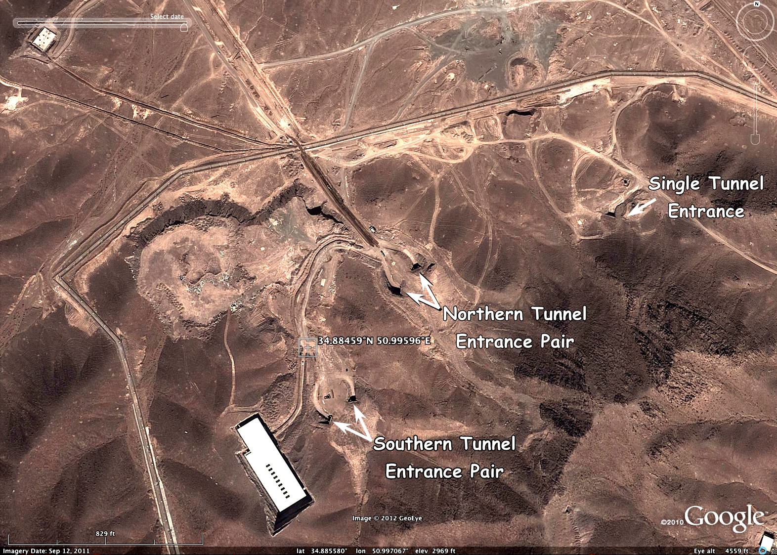
First, here is the latest publicly- available Google Earth view of the facility, with salient features labeled:
Next, that same view with the relevant portion of the article's image georefenced to the "before" image and rendered with transparecy, allowing both to be visible in the overlay area.
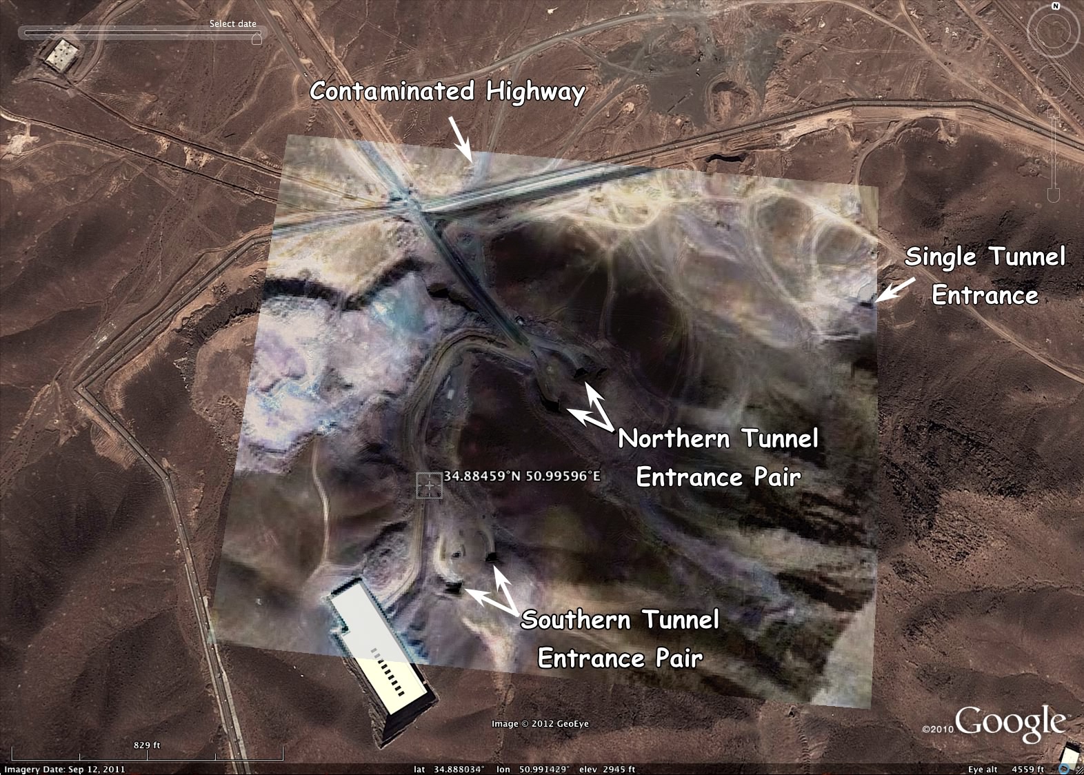
If the article's image is authentic, it is apparent that:
- A significant amount of low-albedo material has been ejected and re-deposited over a large area of the site surface.
- The center of the jecta appears to be associated with the northern pair of tunnel entrances.
- The ejecta deposit extends northward across the highway -- potentially contaminating a section of it.
- I have not been able to identify any evidence of a "bunker buster" bomb being the cause of the damage.
- The facility may be constructed in at least two independent or isolatable sections. There is no visible ejecta directly associated with the southern tunnel entrances or the single tunnel entrance to the east.
- So, only part of the facility may have been directly damaged by the blast. However shock damage may be extnsive throughout the faciity.
- The Iranian nuke program just took a big kick in the teeth -- and they have a big mess on their hands!
45 posted on
01/29/2013 2:36:20 PM PST by
TXnMA
("Allah": Satan's current alias... "Barack": Allah's current ally...)
To: TXnMA
The ejecta should be radioactive and be detectable from down wind sensors. Hopefully we’ll hear more.
To: TXnMA
To: TXnMA
If a partial cause was lithium-ion battery banks, well, let’s just say they ALSO blow up real good, with not a lot of goading.. just my professional experience.
Instant hell on earth if enough go up, and it’s real hard to kill the flame.
50 posted on
01/29/2013 3:09:28 PM PST by
txhurl
To: TXnMA
I figure that the Saudi’s with the clandestine help of the Israeli’s smuggled in a HE a bomb underground that once detonated caused a serious problem. Once the Uranium Hexaflouride breaks down and the HF acid starts to destroy the things the subsequent release of hydrogen gas will further destroy all contained spaces.
Now I would expect the islamonazi’s to send in their special crazies to salvage what’s left.
55 posted on
01/29/2013 3:30:39 PM PST by
Ouderkirk
(Obama has turned America into an aristocracy of the unaccomplished.)
To: TXnMA
Great post, thanks!
(I learned a new word, albedo)
56 posted on
01/29/2013 3:33:43 PM PST by
nascarnation
(Baraq's economic policy: trickle up poverty)
To: Ernest_at_the_Beach; Larry Lucido; battlecry; mnehring; prisoner6; Ray76; Strategerist; ...
My analysis is in
Comment #45.
FYI, I did consider the possibility of cloud shadow, but for a cloud to produce a shoadow anywhere near that dark, the cloud would have to be extremely dense (a very tall cumulonimbus) and very close to the ground, And from the satellite altitude, such a low lying cloud would be visible in the image, In fact, it would have obscured the subject.
If anyone can show me an lmage of an isolated (no visible cloud) cloud shadow on Google Earth that produces that same low albedo and high opacity -- I will reconsider my analysis.
That leaves two alternatives: a dark, dusty deposit -- or Photoshop trickery. I'll see if I can fake the effect on the "before" photo...
58 posted on
01/29/2013 3:37:05 PM PST by
TXnMA
("Allah": Satan's current alias... "Barack": Allah's current ally...)
To: TXnMA
I have not been able to identify any evidence of a "bunker buster" bomb being the cause of the damage.
There were other unconfirmed reports that the facility roof lighting detonated simultaneously in multiple locations. The report went on to say that the explosions were caught on camera prior to the monitoring system going dead.
60 posted on
01/29/2013 3:51:41 PM PST by
PA Engineer
(Liberate America from the Occupation Media.)
To: TXnMA
68 posted on
01/29/2013 6:17:44 PM PST by
nuconvert
( Khomeini promised change too // Hail, Chairman O)
To: TXnMA
If a significant explosion or disaster of any kind occurred an authentic post-photo would show hundreds of trucks, trailers, and heavy equipment for rescue and recovery.
Where are they?
71 posted on
01/29/2013 6:32:58 PM PST by
steve86
(Acerbic by Nature, not Nurture™)
To: TXnMA
Why would the darkened area have such a distinct edge? It’s like the ejecta is distributed evenly within the coverage area, then falls off quickly at its outer extent. Assuming the ejecta is powdery sooty stuff, I would expect a more gradual tapering off as it billowed out and settled around the area. Also, wouldn’t there have been a “nozzling” effect if the ejecta had been blown out of the tunnels with any force, and wouldn’t we see some sign of that near the tunnel entrances? Other than the north tunnels being near the center of the darkened area, I don’t see any signs that they were the source of it. I’d be more inclined to go with the cloud shadow theory except that there’s no cloud in the pic. So I don’t know, kind of puzzling.
To: Ernest_at_the_Beach; gleeaikin; AdmSmith; AnonymousConservative; Berosus; bigheadfred; Bockscar; ...
Thanks Ernest and TXnMA. I changed the reply-to so it links to #45. It's put up or shut up time for the Shiite-heads:
107 posted on
01/30/2013 6:10:33 PM PST by
SunkenCiv
(Romney would have been worse, if you're a dumb ass.)
To: Ernest_at_the_Beach; STD; Larry Lucido; battlecry; mnehring; prisoner6; Ray76; Strategerist; ...
Since most of my current work is OHI (OverHead Imagery) analysis and cartography for archaeology, (detecting and mapping pioneer roads and trails and "vanished" town sites) I usually stick with flat, "orthogonal" ["straight down"] (
aka "ortho") views on Google Earth.
(Deviation from orthogonality [tilting or exaggerating elevation as done for "3-D" viewing] can introduce errors that are unacceptable for accurate mapping.) ...as Apple learned with their aborted "Maps" app...LOL!
Of course, the published "after" image that I was analyzing was orthogonal, so that was the logical place to start. And - georeferencing it and "clamping it to ground" could best be done in the ortho view.
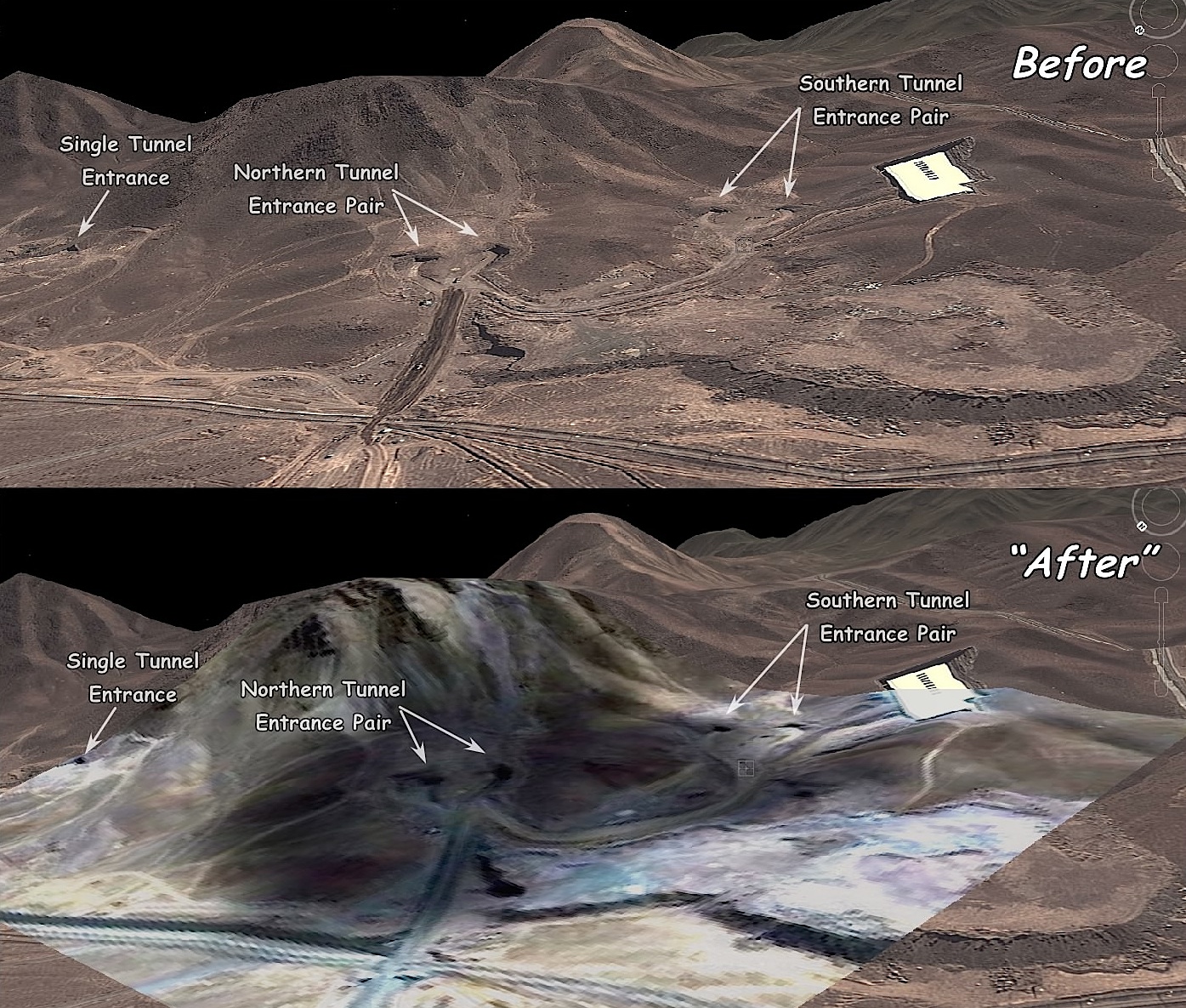
Hence, it wasn't until after I had published my [ortho view] analysis in #45, that I decided to "goof off" and do a 3-D "flyaround look-see" of the Fordo site with Google Earth:
D'OH!!
If I had looked at the 3-D view first -- I wouldn't have wasted time on my published analysis!
~~~~~~~~
First of all, the site looks totally different in the 3-D view. If I had published the 3-D view first, there would have been far less misinterpretation and speculation about "craters", "bunker buster impact points", etc. by thread participants.
For example, the round, so-called "crater" area at upper left on the "ortho" views -- when viewed (at lower right) in the 3-D view -- is obviously a mound or "plateau" built up of "spoil" dirt and rock excavated from the subterranean chambers. (FWIW, I probably could calculate the volume of that "spoil pile" and come up with a prety fair estimation of the volume of the excavted spaces -- but no doubt, our "NTM" ("National Technical Means") folks have already done so with far better accuracy... '-)
~~~~~~~~
Secondly, the "After" view in 3-D makes it obvious that the "soot deposit" was an artificially-added imaging artifact:
- There are obviously no "source point[s]" from which the "soot" was ejected.
- At left, the "ejecta" abruptly stops short of the base terrain level, even though "flowing" down a steep slope.
- Behind the north entrances, the "ejecta" "flowed "UP" the mountain for a considerable distance -- although it lacked the energy to "flow" downhill a similar distance.
- And, most obviously damning: On the "After" image, note the "triangular array of black dots" on the cliff above the "Northeren Entrances" label. Those are pure "imaging artifacts" generated by the "burn" or "darken" filter used to produce the phony "soot deposit" -- exacerbated by the low resolution of the bogus photo. Look at the same spot on the "Before" image: there is nothing there but a naturally-rough cliff face!
Business Insider.com, you are BUSTED!!
~~~~~~~~~~~~~~
Finally, "just for grins", here is a (somewht enhanced) Google Earth "cruise missile view" of the tunnel entrances at Fordo:
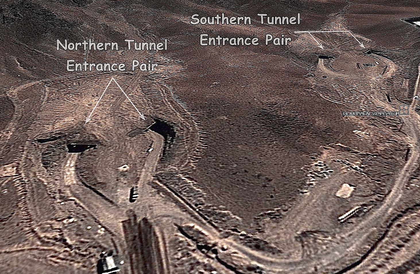
Just think: if a 75 -year old USAF '-) veteran -- in his recliner, out in the Piney Woods boondocks of East Texas -- can produce this view from a website that anyone in the world can access... imagine what today's "NTM" troops are able to do with the "National Technical Means" they have available!! :-)
Pucker-time, Achmadinnerjacket!! <LOL!!!>
120 posted on
01/31/2013 2:07:14 PM PST by
TXnMA
("Allah": Satan's current alias... "Barack": Allah's current ally...)
FreeRepublic.com is powered by software copyright 2000-2008 John Robinson