Skip to comments.
“Alright, Goodnight” – Does Malaysia Want To Know What Happened To Flight MH-370?
SOFREP ^
| March 22, 2014
| Sean Spoonts
Posted on 03/25/2014 6:24:29 AM PDT by yldstrk
On March 8, a Malaysia Airlines Boeing 777-200ER departed from Kuala Lumpur with 227 passengers and 12 crew members. It departed at 12:41am (1441 GMT), and was due in Beijing at 6:30am (2230 GMT) that same day. It hasn’t been seen since. This report attempts to debunk some of the theories about that disappearance and make a new assertion about what might have befallen the passengers and crew of that ill-fated flight. Flight MH 370.
Conspiracy theories don’t hold water because they ignore certain things that have to happen in conjunction with those events in order for them to be correct. What all the theories about the disappearance of this plane leave out are the important aircraft systems that would react (or try to) in any mishap involving the plane. Here are a few.
The Cabin Emergency Depressurization Oxygen System. The “Rubber Mask Jungle” drops if the cabin pressure drops below a certain level – typically at 14,000 feet. The pilots can deploy the system manually or leave it set on automatic. But the pilots cannot turn it off.
Read more: http://sofrep.com/34084/alright-goodnight-malaysia-want-know-happened-flight-mh-370/#ixzz2wyrMzJKF
(Excerpt) Read more at sofrep.com ...
TOPICS: Crime/Corruption; News/Current Events
KEYWORDS: china; flight370; malaysia; mh370; waronterror
Navigation: use the links below to view more comments.
first previous 1-20, 21-40, 41-60, 61-80 next last
To: logi_cal869
>> “It’s the only way any overland route hypothesis is possible, save for another government’s conspiracy in this” <<
.
Nonsense!
Everything about the location of that plane is of the very most sensitive nature. They do want to get the hostages back alive if possible.
.
41
posted on
03/25/2014 9:34:29 AM PDT
by
editor-surveyor
(Freepers: Not as smart as I'd hoped they'd be)
To: gr8eman
because there is no way they could plot or guess coordinates without at least 2 signal sources. I believe they used other planes that were in the air at the same time.
42
posted on
03/25/2014 9:36:07 AM PDT
by
don-o
(He will not share His glory and He will NOT be mocked! Blessed be the name of the Lord forever!)
To: editor-surveyor
Thank you for pushing my interest in this back in the can; no time anyway.
To: logi_cal869
If the sats were to wobble, they couldn’t function.
They use inertial stabilization.
But that is not the issue anyway. They lack any way to measure range from the incoming signal. It would require that the aircraft be sending multiple repetitively coded signals to enable solving integer ambiguity, and that is way outside the capability of the sender and the receiver.
.
44
posted on
03/25/2014 9:46:22 AM PDT
by
editor-surveyor
(Freepers: Not as smart as I'd hoped they'd be)
To: Uncle Chip
Most military "shadowing" is done with 10,000 to 20,000 feet vertical separation, and is all about making a flight of 4 or 6 look like one aircraft.
"Shadowing" is manipulating the weaknesses of primary radar returns, and is not as difficult as you think.
Most radar displays today are computer screens and are NOT real radar scopes, and use computer data over primary returns.
If the controller isn't careful, he'll has his primary radar tuned down to get a very small target and really uses the secondary radar which is the "transponder data" to separate aircraft.
If he doesn't have any "grass" or "clutter" in his primary radar returns, he probably would NOT notice the "Shadowing aircraft".
And at night, with a "lights out", "Shadowing" aircraft, other aircraft in that area would NOT see the darkened aircraft, no matter how large he is.
For the "shadowing" to work, (think in two dimensions) he needs to be almost exactly above the aircraft he's "shadowing" or below him, and the distance between them isn't that critical, just so long as he can match the ground track of the "shadowed" aircraft.
He needs to be on the same radio frequency of the aircraft he's "shadowing", in order to match its speed, turns, climbs, or descents.
The vertical data an air traffic controller sees, comes from the transponder, and if it's turned off, or in standby, the controller won't see it.
45
posted on
03/25/2014 9:55:57 AM PDT
by
Yosemitest
(It's Simple ! Fight, ... or Die !)
To: FatherofFive
Go back and read
comment #27 again.
Read it ALL, because I covered three, not just one, reasons WHY.
46
posted on
03/25/2014 9:59:12 AM PDT
by
Yosemitest
(It's Simple ! Fight, ... or Die !)
To: Yosemitest
To: Uncle Chip
I'm not debating that Lt. Gen. McInerney said that.
When's the last time Lt. Gen. McInerney was "pilot in command" and working the flight controls of an aircraft?
How much has technology changed since Lt. Gen. McInerney last controlled an aircraft?
I'm telling you with over 26 years of USAF air traffic controller experience, most of it as a watch supervisor working directly with "Supervisors Of Flying" (experienced fighter pilots) in the tower cab, that "Shadowing" isn't that difficult to do.
It's a skill that is critical to fighter pilots, as well as most bomber pilots.
48
posted on
03/25/2014 10:34:47 AM PDT
by
Yosemitest
(It's Simple ! Fight, ... or Die !)
To: Yosemitest
I’m sure you will agree that radar technology has been refined over the last 26 years with the increasing ability to catch shadows. It might have been thousands of feet 5-10-20 years ago but it’s down to a couple hundred feet now.
And the General also said that our “best sensors” are in Afghanistan — which means that even if it went undetected by Indian radar and Pakistani radar, it would have been picked up by our “best sensors” in Afghanistan.
To: editor-surveyor
Not going to get into
satcomms/wobble/Doppler & signal locating; not my area (despite being a geek and curious) and I don't have the time. What they stated is plausible, but I remain skeptical until others can see/review the data.
I agree with your latter and it is the basis for (my) questioning all the conclusions based on the 'Inmarsat data'. That, coupled with the long delay.
Doppler Frequency Offset Compensation is way outside my sphere, but the claims made should be backed up with detailed reports, not spoon-fed as media releases.
I think the issue most agreed to here is the complete lack of credibility thus far.
(oh, and the fact that the flight crew were muslim...)
I, for one, at least, find it decidedly coincidental that MH370 disappeared under (continuing) mysterious circumstances nary a week following what's been described in media as 'China's 9/11' (my immediate reaction the day-of), the Captain's relation to Anwar Ibrahim, and the steady stream of inconsistent data on the missing plane.
I am skeptical that any of the governments involved truly want the 'facts' exposed.
Deja vu, anyone?
To: Uncle Chip
Airliners don’t normally make altitude or course changes without ‘permission’ from flight controllers. A shadowing aircraft could tune their radios in to the same frequencies as the bug aircraft and they would be forewarned of most changes that were being planned.
51
posted on
03/25/2014 11:36:41 AM PDT
by
B4Ranch
(Name your illness, do a Google & YouTube search with "hydrogen peroxide". Do it and be surprised.)
To: FatherofFive; Yosemitest
FatherofFive, are you at least going to say thanks for the detailed answer?
52
posted on
03/25/2014 11:45:06 AM PDT
by
B4Ranch
(Name your illness, do a Google & YouTube search with "hydrogen peroxide". Do it and be surprised.)
To: Uncle Chip
"I’m sure you will agree that radar technology has been refined over the last 26 years with the increasing ability to catch shadows. …"
In a very few places.
Haven't you heard or read of the budget constraints that we are under and of the F.A.A. complaining of the outdated equipment problems?
And if we are behind, WHERE do you think MOST countries in the world are at with that technology?
Now in a very few cases you are correct.
But very few places have
Standard Terminal Automation Replacement System (STARS) and ASR-11 Digital Airport Surveillance Radar (DASR).
Other radar systems such as
Airborne Warning And Control System (AWACS) aircraft and
ground control of intercepts (GCI) radars have the technology that you describe.
But not MOST Air Traffic Control Radar Facilities, mostly due to government cutbacks and cost.
Now our best sensors WERE in Afghanistan, but the ILLEGAL ALIEN IN CHIEF has ordered us OUT of there, and soon.
Also, if you'll look at a map, there's plenty of Pakistan that is well south of Afghanistan and it connects directly with Iran.
With the Pakiastan Government helping MH370, he's have had no problems getting across India and into Pakistan, or into Iran after refueling.
Are you familiar with "Chaff", "Buzzer", and other types of radar jamming?
53
posted on
03/25/2014 12:01:49 PM PDT
by
Yosemitest
(It's Simple ! Fight, ... or Die !)
To: B4Ranch
The only detail I saw worth my time was the graphic on the Boeing 777, but it was of a 300 Series and
not a 200 series. Also I'd like verification that MH370 was a Boeing 777-200
ER (Extended Range).
Take a look at the fuel capacity of the different models of Boeing 777-200,Maximum Fuel Capacity can be from 31,000 U.S. gal (117,340 L) for the 777-200, to 45,220 U.S. gal (171,170 L) for the 777-200 ER, to 47,890 US gal (181,283 L) for the 777-200 LR, depending on the configuration,
and that can give it a Maximum range (at maximum payload {because MH370 might have weighed less, giving it a LONGER range} ) of from5,240 nautical miles (9,700 km, 6,027 miles) to 7,725 nmi (14,310 km, 8,892 mi) to 9,380 nmi (17,370 km, 10,793 mi), depending on its configuration.
That changes the fuel load capacity considerably.
The amount of fuel pumped into the aircraft
isn't the amount of fuel ON the aircraft. There's ALWAYS some fuel left in the tanks after it lands, so you need to know how much fuel he had total, and not just how much fuel he ordered.
54
posted on
03/25/2014 12:21:18 PM PDT
by
Yosemitest
(It's Simple ! Fight, ... or Die !)
To: B4Ranch
I’m betting that to get this right it would take a lot of practice and some degree of coordination.
To: Yosemitest
What is your best guess as to how much fuel he had on board — they are saying that he had 8 hours of fuel — 6 to Beijing and 2 for emergencies.
If he flew at say 10,000ft rather than 35,000ft at its cruising speed of 360mph how much more fuel at that lower altitude would he burn up???
To: Uncle Chip
I'd be scared to guess, but if he was planning this, and this was the exact aircraft that he normally flew, he could bump up the order of fuel every order over a period of time, to get a higher reserve.
And due to the delay of invoices showing up for a few days or weeks, the company might not realize that this aircraft had a considerable amount of fuel on board, more than required for regulated reserves.
The book says that the 777 is designed to fly at 35,000 feet and the lower you go the more fuel you burn due to air density.
I'm not an aircraft loadmaster and I haven't figured fuel burn rates in a very long time (aircraft performance college class in 1980).
You'd need to know the exact aircraft's total weight, as well as a lot of other facts, before you start the plotting that fuel burn rate.
57
posted on
03/25/2014 12:49:11 PM PDT
by
Yosemitest
(It's Simple ! Fight, ... or Die !)
To: logi_cal869
I agree with you that they lack credibility .
From the
Geosynchronous orbit of
Inmarsat's communication equipment.
So that's WHY the arc is
"over a 1000 miles long" . Because of the dependance on the Satellite's 40 degree arc being the LAST communication from MH370, you should know
this ,:
 " Space Weather, From Physics World, July 2000, by Janet Luhmann
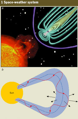
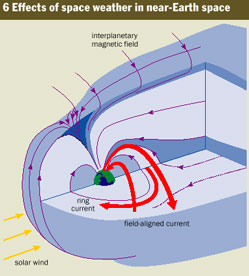
... Space weather describes the conditions that prevail above the stratosphere - that is at altitudes of about 50 km and above - where responses to solar influences are particularly strong.
The regions that are affected include the Earth's upper atmosphere and the ionosphere - the ionized region of the upper atmosphere that extends for a few hundred kilometres into space.
The conditions also change the intensity of the radiation belts in the magnetosphere - the region beyond the ionosphere where electrons and ions are trapped by the Earth's magnetic field (figure 1).
Space weather is caused by the Sun's influence on the region of interplanetary space beyond the reach of the Earth's magnetic field.
This region is filled with a stream of protons and electrons from the outer atmosphere of the Sun together with its magnetic field, which collectively form the solar wind.
Stormy space-weather conditions are usually inferred from deviations in the magnetic fields that are measured by satellites and ground-based instruments.
These disturbances can also be deduced from conditions in the upper atmosphere and ionosphere, where intensified auroras and airglows are found.
At higher altitudes the intensity of both electromagnetic and particle radiation increases, which can pose a hazard for astronauts and possibly even for aircrew travelling on high-altitude routes(see "Cosmic rays: an in-flight hazard?" by Denis O'Sullivan Physics World May 2000 p21).
In addition to power and communications failures on the ground, disturbed space weather increases the risk to space-craft on several counts.
During stormy conditions, communication and weather satellites that reside on the outer edges of the radiation belt can suddenly find themselves in an environment that differs from the one for which they were originally designed.
 The boost in the intensity of the electromagnetic radiation at extreme ultraviolet wavelengths heats the upper atmosphere and causes it to inflate.
The resulting increase in the density of atmospheric gases at satellite altitudes can increase the atmospheric friction or drag on spacecraft, which can affect their orbit.
In the 1970s the Skylab space station re-entered the Earth's atmosphere prematurely following a period of unexpectedly high solar activity.
Indeed, this type of atmospheric drag is an ongoing concern with regard to the Hubble Space Telescope.
Furthermore, since signals to and from satellites are transmitted through the ionosphere, there is a far greater risk that instructions from a command centre will be affected during stormy space weather.
The performance of several expensive satellites, including the Intelstat and GOES-8 satellites in 1995 and Telesat in 1996, suffered briefly during or after a sequence of space-weather events.
More seriously, one of the Telstar satellites was lost in 1997 following such an event. "
So,
satellite orbits are not "Stable" and that 40 degree arc
isn't so dependable, either.
58
posted on
03/25/2014 12:54:43 PM PDT
by
Yosemitest
(It's Simple ! Fight, ... or Die !)
To: Yosemitest
MH370 was a Boeing 777-200 ER (Extended Range). That what is being reported.
All 14 of their 777's are ER's. I think this may be the one we know as MH370. Boeing 777-2H6(ER) 9M-MRO Malaysia Airlines Delivery date 31-05-2002 Written Off Look here for the complete list. http://www.planespotters.net/Production_List/Boeing/777/index.php?sort=reg&dir=asc
59
posted on
03/25/2014 1:22:59 PM PDT
by
B4Ranch
(Name your illness, do a Google & YouTube search with "hydrogen peroxide". Do it and be surprised.)
To: B4Ranch
That's an informative link.
Thanks.
60
posted on
03/25/2014 1:31:54 PM PDT
by
Yosemitest
(It's Simple ! Fight, ... or Die !)
Navigation: use the links below to view more comments.
first previous 1-20, 21-40, 41-60, 61-80 next last
Disclaimer:
Opinions posted on Free Republic are those of the individual
posters and do not necessarily represent the opinion of Free Republic or its
management. All materials posted herein are protected by copyright law and the
exemption for fair use of copyrighted works.
FreeRepublic.com is powered by software copyright 2000-2008 John Robinson
 "Telecommunications satellites, as well as other types of satellites, maintain a geosynchronous orbit known as the Clarke orbit.