Bent bump ping.
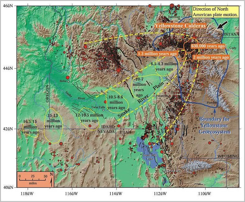
Figure 1. Path of the Yellowstone hotspot. Yellow and orange ovals show volcanic centers where the hotspot produced one or more caldera eruptions- essentially "ancient Yellowstones"- during the time periods indicated. As North America drifted southwest over the hotspot, the volcanism progressed northeast, beginning in northern Nevada and southeast Oregon 16.5 million years ago and reaching Yellowstone National Park 2 million years ago. A bow-wave or parabola-shaped zone of mountains (browns and tans) and earthquakes (red dots) surrounds the low elevations (greens) of the seismically quiet Snake River Plain. The greater Yellowstone "geoecosystem" is outlined in blue. Faults are in black.
 |
||
| · join · view topics · view or post blog · bookmark · post new topic · | ||
|
|
|||
Gods |
Thanks decimon. |
||
|
· Discover · Nat Geographic · Texas AM Anthro News · Yahoo Anthro & Archaeo · Google · · The Archaeology Channel · Excerpt, or Link only? · cgk's list of ping lists · |
|||
I’ve always wondered if it was the same hot spot responsible for the Siberian Traps, since the trail points in that general direction.
Uh-oh. That means Yellowstone is about to go boom.
Young-earthers will be deeply saddened.