Free Republic
Browse · Search
General/Chat
Topics · Post Article

This is a map showing the structure and contour of the Bow City crater. Color variation shows meters above sea level. Credit: Alberta Geographic Survey/University of Alberta
This is a map showing the structure and contour of the Bow City crater. Color variation shows meters above sea level.

1 posted on 05/13/2014 3:39:36 PM PDT by SunkenCiv
[ Post Reply | Private Reply | View Replies ]


To: SunkenCiv
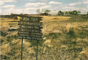
The first hints about the impact site near the southern Alberta hamlet of Bow City

Not much left of it. Behind the sign you can faintly make out the foundation of the old general store, next to that used to be a garage, I have found old oil cans and other parts in the field there in the past.


3 posted on 05/13/2014 4:08:36 PM PDT by caveat emptor (!)
[ Post Reply | Private Reply | To 1 | View Replies ]

“The measure of a man is what he does with power.”

~Plato


help support the most conservative online site
click the pic


4 posted on 05/13/2014 4:09:18 PM PDT by trisham (Zen is not easy. It takes effort to attain nothingness. And then what do you have? Bupkis.)
[ Post Reply | Private Reply | To 1 | View Replies ]

To: SunkenCiv

I’ve had a theory for some years, the much of the Rockies was caused by an array of objects that came to earth, affecting a north-to-south axis, crumpling the earth’s crust. The crater mentioned in the article, would be in the northern range of these impacts.

One of the largest of the southern-most (within the U.S. states) impacts would be the Caldera, where Los Alamos is located (eastern slope), and Redondo is the roughly central peak that resulted from the splash.

I suspect that the earth in areas distantly around the Caldera, but not near and of the Caldera, prior to that impact, was a crust resting upon enormous caverns and voids, thru some of which flowed molten material consisting of very high concentrations of metal (particularly east of present day Los Alamos ... about 10 - 18 miles. (This material was *not* released by the impact.)

South of the Caldera, the land rested upon mostly hollow caverns and voids, which collapsed when the impact occurred -— because of vibration and because of the weight of the debris released by the impact.


5 posted on 05/13/2014 4:15:14 PM PDT by First_Salute (May God save our democratic-republican government, from a government by judiciary.)
[ Post Reply | Private Reply | To 1 | View Replies ]

To: SunkenCiv
I am most familiar with geographic coordinates, degrees/minutes/seconds.
Does anyone have a clue what coordinate system is used on the map related to the article/post?

Is there a reason why the coordinates of the crater center is not given?

6 posted on 05/13/2014 6:24:23 PM PDT by publius911 ( At least Nixon had the good grace to resign!)
[ Post Reply | Private Reply | To 1 | View Replies ]

Free Republic
Browse · Search
General/Chat
Topics · Post Article


FreeRepublic, LLC, PO BOX 9771, FRESNO, CA 93794
FreeRepublic.com is powered by software copyright 2000-2008 John Robinson