Skip to comments.
Lost city of Atlantis FOUND in Antarctica? Bizarre structure exposed by melting ice
https://www.dailystar.co.uk/ ^
| 4/14/18
| Callum Hoare
Posted on 04/14/2018 2:19:24 PM PDT by BBell
click here to read article
Navigation: use the links below to view more comments.
first previous 1-20, 21-40, 41-60, 61-80, 81-94 next last
To: SunkenCiv
Just what I need to pass the time as it is snowing hard and will be right through sometime tomorrow. Expecting over 5”, SE Wisconsin
61
posted on
04/15/2018 4:35:52 AM PDT
by
PIF
(They came for me and mine ... now it is your turn ...)
To: mad_as_he$$
Or its the Alien Vs Predator base. Beware all those who enter you may lose your stomachs after a rather painful facial.
62
posted on
04/15/2018 4:51:02 AM PDT
by
zaxtres
To: PIF
63
posted on
04/15/2018 5:26:34 AM PDT
by
SunkenCiv
(www.tapatalk.com/groups/godsgravesglyphs/, forum.darwincentral.org, www.gopbriefingroom.com)
To: SunkenCiv
Not Friday ... next Monday (not this one).
Is there any truth to the rumor that there is a 300’ glacier forming near Edmonton, and advancing south?
What about cave bears? Should I make more flint arrows and spears?
64
posted on
04/15/2018 5:40:03 AM PDT
by
PIF
(They came for me and mine ... now it is your turn ...)
To: zaxtres
Santa has claims to the North Pole so I'm betting that they found the antipode lair of the anti-santa.

65
posted on
04/15/2018 6:00:01 AM PDT
by
Sirius Lee
(In God We Trust, In Trump We MAGA)
To: PIF
If you know how to do flint knappiing and other stone age skills, concentrate on making a bump stock for your AR-15, ****ed cave bears! ;^)
66
posted on
04/15/2018 6:00:30 AM PDT
by
SunkenCiv
(www.tapatalk.com/groups/godsgravesglyphs/, forum.darwincentral.org, www.gopbriefingroom.com)
To: SunkenCiv
concentrate on making a bump stock for your AR-15, ****ed cave bears! ;^)
—
Alas my AR15 is still in the store ... and anyway rounds would run out eventually and that is just when the mother of all Cave Bears would put in an appearance ... So its back to dead falls, poisoned punji stakes, atlatals, trebuchets, arrowhead making and so on ... at least they won’t run out ...
67
posted on
04/15/2018 6:54:49 AM PDT
by
PIF
(They came for me and mine ... now it is your turn ...)
To: BBell
68
posted on
04/15/2018 7:47:03 AM PDT
by
jimjohn
(2nd American Civil War: ongoing since January 20, 2017.)
To: SunkenCiv
They based their idea on Charles Hapgood’s idea of crustal displacement.I understand that Hapgood based his theory on the fact that the poles (forgot which one) ice built up until it threw the Earth off balance. He recanted when it was proved that the equatorial bulge would prevent that.
I think the Flem-Ath book figured it was a near miss by a celestial body (along the lines of Velikovsky) and the shift was 17%, throwing the Antarctica into the frigid zone.
The only response I’ve seen to that fossil evidence is by some alleged scientist who claimed that those fossils (and nothing else) were plucked from an unknown location in South America and dropped into the snow.
I've these ridiculous counter-claims postulated so often that I seriously doubt modern day scientists as to pre-historical civilizations. Much tap-dancing when an out-of-place part is found in an "impossible" strata.
After reading Velikovsky's "Earth in Upheaval" I have to wonder, if he is right, our geology based on age-by-strata isn't completely out of whack. i.e. that 5-million-year-old iron hammer might have been buried in historical times by some kind of cataclysmic upheaval that placed it to that level.
69
posted on
04/15/2018 10:53:57 AM PDT
by
Oatka
(tHE)
To: Oatka
From that map it looks like Antartica fits neatly into the Indian Ocean side of Africa, and Australia fits into Antartica on it’s western lower side.
70
posted on
04/16/2018 7:27:02 PM PDT
by
Bellflower
(Who dares believe Jesus. He says absolutely amazing things, which few dare consider.)
To: Oatka
Piri Reis Map"Potentially one of the most significant finds of modern time as it is clearly dated 1513 AD and shows both the coastlines of the American and debatably, the Antarctic coastline (which has been frozen over since around 4,000 BC)"
71
posted on
04/16/2018 8:08:06 PM PDT
by
Garth Tater
(Knowledge control - like gun control - only disarms the law abiding citizen)
To: fieldmarshaldj; StayAt HomeMother; Ernest_at_the_Beach; 1ofmanyfree; 21twelve; 24Karet; ...
Note: this topic is from . Thanks fieldmarshaldj. I'd forgotten about this topic, and it's good and nuts, I regret having neglected to ping it.

72
posted on
11/20/2018 6:28:08 PM PST
by
SunkenCiv
(and btw -- https://www.gofundme.com/for-rotator-cuff-repair-surgery)
To: BradyLS
Giant, blind, albino penguins!
To: bigbob
74
posted on
11/20/2018 6:38:20 PM PST
by
Pelham
(Secure Voter ID. Mexico has it, because unlike us they take voting seriously)
To: mad_as_he$$
Thanks to Colonel Jack Oneill who saved the day by activating the ancient defense from the cool chair.
Too bad he had to go into hibernation.
I wonder if his pay accumulated while he was sleeping?
75
posted on
11/20/2018 6:38:53 PM PST
by
oldvirginian
( Buckle up kids, rough road ahead.)
To: Garth Tater
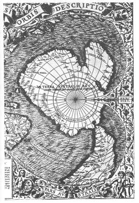
The presence of the Antarctic continent on the Piri-reis map is in debate, with suggestions that the bottom tip of the south American continent was simply ‘squeezed’ on, following a miss-judgment in size by Piri-reis. Regardless of this, there are other ancient maps which clearly do have the outline of the continent on them, with both Gerard Mercator's map of 1569 AD
and the Oronteus Finaeus map of 1532 AD (right), also showing the coastline, and the Hadji Ahmed map of 1559 AD, which not only has Antarctica with a correct Mercatorial projection but also shows a land bridge between the Bering straits, re-enforcing the suggestion of an antiquitous origin. The specific division of the Antarctic continent into two smaller land-masses on these ancient maps is similarly a mystery as it was only at the end of the 20th century that we were finally able to determine (through satellite technology) the accurate outline of the Antarctic continent, which was found to be identical to those seen on some of the oldest surviving maps of the world.
ORONTEUS MAP
76
posted on
11/20/2018 6:39:12 PM PST
by
Fred Nerks
(fair dinkum!)
To: Jim Noble
“He says the sheriff is a’near.”
77
posted on
11/20/2018 6:40:48 PM PST
by
BenLurkin
(The above is not a statement of fact. It is either satire or opinion. Or both.)
To: Flag_This; PrairieDawg
78
posted on
11/20/2018 6:42:25 PM PST
by
Pelham
(Secure Voter ID. Mexico has it, because unlike us they take voting seriously)
To: Garth Tater
79
posted on
11/20/2018 6:45:25 PM PST
by
Fred Nerks
(fair dinkum!)
To: redcatcherb412; Pelham; oldvirginian; Fred Nerks; BenLurkin
80
posted on
11/20/2018 8:07:32 PM PST
by
SunkenCiv
(and btw -- https://www.gofundme.com/for-rotator-cuff-repair-surgery)
Navigation: use the links below to view more comments.
first previous 1-20, 21-40, 41-60, 61-80, 81-94 next last
Disclaimer:
Opinions posted on Free Republic are those of the individual
posters and do not necessarily represent the opinion of Free Republic or its
management. All materials posted herein are protected by copyright law and the
exemption for fair use of copyrighted works.
FreeRepublic.com is powered by software copyright 2000-2008 John Robinson

