
Posted on 09/09/2018 8:01:18 AM PDT by NautiNurse
September 10 is the statistical peak of the Atlantic Tropical Storm season, and the conga line of storms dancing across the Atlantic is not disappointing historical data. The Governors of NC and SC have declared states of emergency for a potential major hurricane landfall, while Hurricane Florence is slowly creeping westward. Florence is predicted to increase forward motion and intensity Monday. Hurricanes Hazel (1954) and Hugo (1989) are two notorious major hurricanes to make landfall in NC and SC, respectively. North Carolina has prior experience with "F" named hurricanes. Hurricanes Fran (1996) and Floyd (1999) caused widespread flooding and damage in the Tar Heel state.
The NHC has been issuing Public Advisories for Florence since August 30. The five day "Cone of Uncertainty" archive progression since Aug. 30 may be found here.
Isaac is a small storm. Isaac is predicted to steadily strengthen during the next few days as the storm remains over warm waters and in a low wind shear environment in the short term. The NHC predicts Isaac will reach hurricane status within 2 days.
Helene is expected to reach hurricane status in the short term. However, Helene is not anticipated to threaten U.S. interests. The forecast track turns north into the mid-Atlantic.
Click on the images below to enlarge

IF ya’ll get close to rain they are predicting some of those little villages on the east side of the Blue Ridge could be subjected to major flash flooding.
I was in Blowing Rock Boone in May. I can not imagine how bad some of those driveways and roads could get after 1-3 feet of rain. I thought my driveway was bad here in NH. I saw houses there in the Blowing Rock area that had a driveway that were treacherous on a 70 degree sunny day.
These were last night runs....new Euro just starting...ensembles will come late the afternoon
New version of GFS continues to be SW of the old GFS
UKMET model central NC coast,,similar to the exp-gfs
Outer Banks Motel, Buxton NC on Hatteras Island. It is at the northern end of Buxton
We stayed in this motel last year and the ocean is perilously close in good weather. I have my doubts it can survive a near miss hurricane.


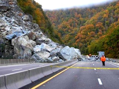
Highway 40 thru the Blue Ridge Mts. is terrifying - rock slide potential all the way!!!! Hope this storm with the rainfall doesn’t make it that far.
Okay, I misread the date/timestamp.................
That motel looks like it lives in the surf already. Amazing.
new Euro about the same hits near Wilmington NC then is well inland by Friday morning
Know the areas well. Was in the USMC stationed at Camp LeJeune...................
Curious to see what "well inland" means. If you look at the NOAA graphic below, it is important to note that from the time the storm approaches the coast, it will take almost 48 hours to go 200 miles inland. That is just a little over walking pace while dumping a lot of water in her wake.
Typically, in the past, 48 hours after a NC landfall, the storm is in New England or points further northeast. In this case, however, the forecast has it still within the state.

That’s what worries me, the flooding. We are along the I-95 corridor, Rocky Mt/Wilson.....I remember, like it was yesterday, all the floods after Floyd. It was awful. Our property was fine [other than downed trees], but we could not get out. Every road we tried to take was either flooded or washed away. With all the rain predicted for this storm, I wonder if it will be a repeat of Floyd?
That’s what I’m talkin’ ‘bout. Terrifying!
South Carolina Governor ordering mandatory evacuation on Tuesday.
East Carolina University is canceling classes that start after 12 p.m. Tuesday and there will be no more classes for the remainder of the week.
Dare County issued a mandatory evacuation order for all visitors and residents of Hatteras Island that will go into effect Monday at 12 p.m. A mandatory evacuation order for those in other areas of Dare County goes into effect Tuesday at 7:00 a.m.
Brunswick County ordered a mandatory evacuation for residents who live in low-lying and flood-prone areas or substandard or mobile homes, beginning at 7 a.m. Tuesday.
South Carolina Gov. Henry McMaster will order evacuations along South Carolina’s entire 187-mile coastline border starting at noon Tuesday.
One out of every five South Carolinians, about 1 million in all, are in the evacuation zones covering eight counties.
 South Carolina Ping
If you'd like to be on or off the South Carolina ping list, just click Private Reply below and drop me a FReepmail.
There's gonna be a jillion articles on Florence this week. Pardon me if I miss pinging some.
Euro had no stall and moved it into Michigan Likely will get ignored for now
Yeah, Va Beach will get a lot of rain, but the biggest threat to you will be the storm surge. My daughter lives in Va Beach as well (off Witchduck); her neighborhood flooded fairly easily, so we told her to be ready to come to Gloucester.
Recon now supports 135-140 mph and pressure around 941mb
it may level off for now....often there are 2 phases of rapid ramp up..
Disclaimer: Opinions posted on Free Republic are those of the individual posters and do not necessarily represent the opinion of Free Republic or its management. All materials posted herein are protected by copyright law and the exemption for fair use of copyrighted works.


