Skip to comments.
Icelandic Volcano Caused Historic Famine In Egypt
Terra Daily ^
| 11/22/2006
| Staff Writers
Posted on 11/22/2006 8:44:38 AM PST by cogitator
click here to read article
Navigation: use the links below to view more comments.
first 1-20, 21-25 next last
Here's what the Laki fissure area looks like now:

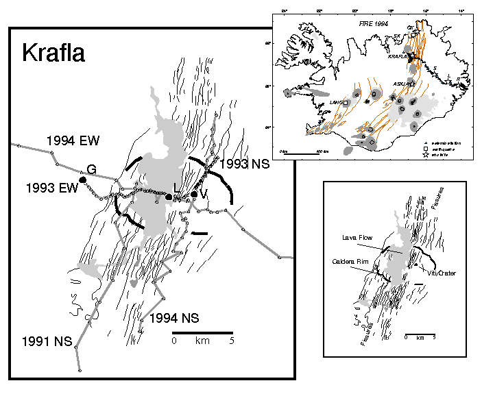
This is a picture of an eruption of Krafla, which is also on the rift zone; it gives an impression of what the Laki fissure eruption might have been like. Just add more lava and gas. Krafla is north of the Vatnajokull ice cap; the Laki fissures trend southwest from the ice cap (see map below picture).

1
posted on
11/22/2006 8:44:41 AM PST
by
cogitator
To: 2Trievers; headsonpikes; Pokey78; Lil'freeper; epsjr; sauropod; kayak; Miss Marple; CPT Clay; ...
2
posted on
11/22/2006 8:55:58 AM PST
by
cogitator
To: cogitator
You mean SUVs did not cause famine in Egypt and a volcano in Iceland back in 1783? HMPF!!!!
/sarcasm
3
posted on
11/22/2006 10:09:56 AM PST
by
BossLady
(Islamic Motto: We Love Our Women To Death........)
To: BossLady
Actually, if the Laki fissure eruption could be classified as Sub-arctic Unusual Volcanism (SUV), maybe it did...
4
posted on
11/22/2006 10:27:09 AM PST
by
cogitator
To: 75thOVI; Alice in Wonderland; AndrewC; Avoiding_Sulla; BenLurkin; Berosus; CGVet58; chilepepper; ...
5
posted on
11/22/2006 10:27:49 AM PST
by
SunkenCiv
(I last updated my profile on Thursday, November 16, 2006 https://secure.freerepublic.com/donate/)
To: blam; FairOpinion; StayAt HomeMother; Ernest_at_the_Beach; 24Karet; 3AngelaD; ...
Although this is about an 18th century eruption, it's of some interest I'm sure, so here's a ping. And a Happy Thanksgiving to everyone. Drive safely.
To all -- please ping me to other topics which are appropriate for the GGG list. Thanks. Please FREEPMAIL me if you want on or off the
"Gods, Graves, Glyphs" PING list or GGG weekly digest
-- Archaeology/Anthropology/Ancient Cultures/Artifacts/Antiquities, etc.
Gods, Graves, Glyphs (alpha order)
6
posted on
11/22/2006 10:29:23 AM PST
by
SunkenCiv
(I last updated my profile on Thursday, November 16, 2006 https://secure.freerepublic.com/donate/)
To: BossLady
7
posted on
11/22/2006 10:32:04 AM PST
by
maryz
To: cogitator
OOOOOOOoooooo....I like it!!!! Let's try spinning it!
((Said by Al Gore... wringing his hands and licking his chops...))
8
posted on
11/22/2006 10:33:16 AM PST
by
BossLady
(Islamic Motto: We Love Our Women To Death........)
To: maryz
hmpf explanation:
The sound one makes in response to something peculiar that has just occurred or has just been said. Most often used when irritated. Most often a natural response/reaction.
9
posted on
11/22/2006 10:43:12 AM PST
by
BossLady
(Islamic Motto: We Love Our Women To Death........)
To: BossLady
Oh, okay. Should have thought of that, but since it was all caps, I thought it was an acronym. Thanks!
10
posted on
11/22/2006 10:49:46 AM PST
by
maryz
To: maryz
I capatilized it cause I was playing a whiney liberal...hehehehe.... ;)
11
posted on
11/22/2006 11:00:00 AM PST
by
BossLady
(Islamic Motto: We Love Our Women To Death........)
To: BossLady
OOOOOOOoooooo....I like it!!!! Let's try spinning it!
((Said by Al Gore... wringing his hands and licking his chops...))

12
posted on
11/22/2006 11:15:38 AM PST
by
StoneGiant
(Power without morality is disaster. Morality without power is useless.)
To: StoneGiant
13
posted on
11/22/2006 11:57:45 AM PST
by
BossLady
(Islamic Motto: We Love Our Women To Death........)
14
posted on
11/22/2006 12:00:28 PM PST
by
SunkenCiv
(I last updated my profile on Thursday, November 16, 2006 https://secure.freerepublic.com/donate/)
To: SunkenCiv
I love that stuff. And:
Constantinople's Volcanic Twilight (Kuwae eruption)
Huaynaputina (includes image)
"Huaynaputina was the site of a single catastrophic eruption in February 1600, which was remarkable not only for its intensity, but because it was the only major explosive eruption in historic times in the Central Andes. A colourful account of the eruption is to be found in the journals of Vasquez de Espinoza (translated from the Spanish in 1942). The eruption completely destroyed the pre-1600 edifice which was described as " a low ridge in the centre of a sierra". Ash from the eruption is widespread and still mantles much of the surrounding countryside as far as Arequipa, 80 km away. It now forms a useful regional stratigraphic marker horizon throughout Peru (e.g. in the Quelccaya ice cap (see Chapter 1, Figure 8; Thompson et al., 1986). In the Greenland ice core acidity profile, the eruption produced an acid "spike" larger in magnitude than the Krakatau 1883 eruption (Hammer et al., 1980; de Silva & Francis, 1990) and remarkable optical effects were reported from the northern hemisphere in 1601 (Lamb, 1970). Notwithstanding the magnitude of this eruption, its deposits have never been examined."
From the Global Volcanism Program (excerpt):
"This powerful fissure-fed eruption may have produced nearly 30 cu km* of dacitic tephra, including pyroclastic flows and surges that traveled 13 km to the east and SE. Lahars reached the Pacific Ocean, 120 km away. The eruption caused substantial damage to the major cities of Arequipa and Moquengua, and regional economies took 150 years to fully recover."
* Tambora is estimated to have been 80 cubic km.
To: cogitator
The Voyage of Hanno
Livio Catulo Stecchini
"Sailing rapidly, we passed by a fiery region filled with vapors, from which great torrents of fire flowed down to the sea. The land could not be approached because of the heat.
"We sailed away from there quickly, being struck with fear. Then, having sailed for four days, we sighted at night a land full of flames. And in the midst of it there was a fire higher than the rest which seemed to touch the stars. By day we discerned it to be a mountain of great height named Theon Ochema."
In describing a volcanic eruption from a high mountain towering over the sea Hanno mentions such details as sulphuric fumes and streams of lava. The only volcanic area in West Africa is represented by Mount Cameroon, which is still active today. It is located at the deepest point of the Gulf of Guinea, where it rises suddenly from the seashore, reaching a height of over 4000 meters. The peak of Mount Cameroon is at 4°13'N, 9°10'E. almost exactly 6° (equal to four days' sailing) east of the Great Island of Lagos. Those who have seen it from the sea consider it one of the most impressive sights in the world. The natives call it Mongana-Loba, "Mountain of the Gods," which well agrees with the Greek Theon Ochema, "Chariot of the Gods," of our text.
16
posted on
11/22/2006 12:47:20 PM PST
by
SunkenCiv
(I last updated my profile on Thursday, November 16, 2006 https://secure.freerepublic.com/donate/)
To: SunkenCiv
It's real hard to find a good image from the ground of Mount Cameroon, because of all the clouds?


Typical shot. But shield volcanoes don't make great photographic subjects (from a distance) anyway. There are a few low-cloud images on the Web - it looks like a big hill.
To: StoneGiant
18
posted on
11/22/2006 5:30:01 PM PST
by
WSGilcrest
(Mikey likes it!)
To: cogitator
19
posted on
11/22/2006 8:18:27 PM PST
by
SunkenCiv
(I last updated my profile on Thursday, November 16, 2006 https://secure.freerepublic.com/donate/)
To: cogitator; SunkenCiv
Regarding the famine in Egypt, there is an interesting modern parallel. I think it was in the late 1970s that the terrible north African drought in the Sahel caused such fatal famine. I came across a recent report that this was influenced toward severity by particulate air pollution drifting down from Europe. Since Europe has been cleaning up its air in recent decades, the droughts in north Africa have not been so severe.
Navigation: use the links below to view more comments.
first 1-20, 21-25 next last
Disclaimer:
Opinions posted on Free Republic are those of the individual
posters and do not necessarily represent the opinion of Free Republic or its
management. All materials posted herein are protected by copyright law and the
exemption for fair use of copyrighted works.
FreeRepublic.com is powered by software copyright 2000-2008 John Robinson
