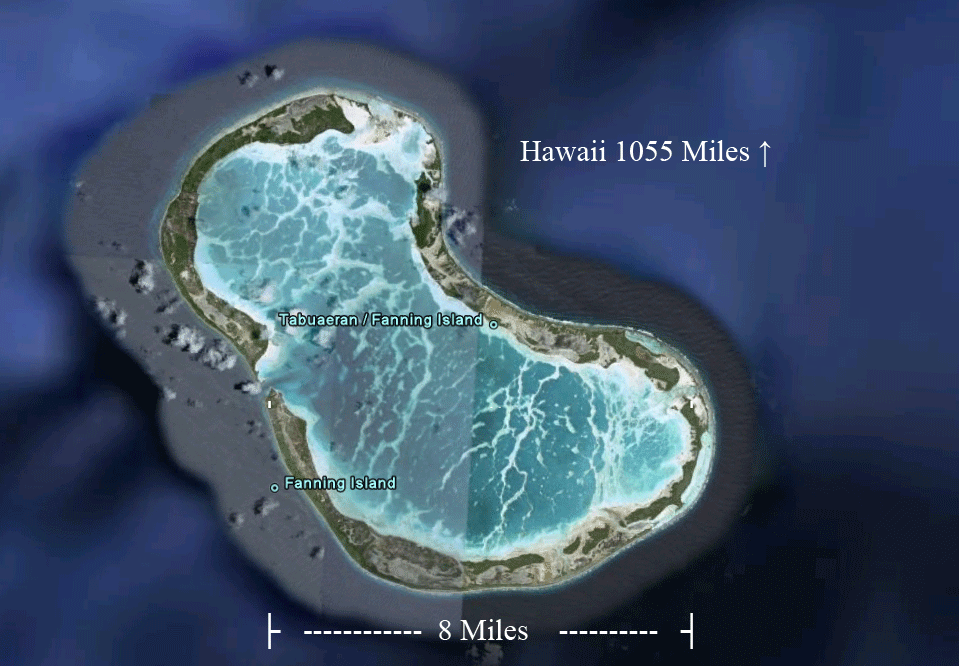
Our Hawaii cruise ship visited Fanning Island in the Republic of Kiribati, 1000 miles south of Hawaii. This 9 mile by 6 mile atoll with a huge central lagoon averaged 10 feet above sea level!
Posted on 01/03/2017 4:04:10 PM PST by Sean_Anthony
New research shows the islands are growing, not receding
Once a year or so, journalists from major news outlets travel to the Marshall Islands, a remote chain of volcanic islands and coral atolls in the Pacific Ocean, to report in panicked tones that the island nation is vanishing because of climate change. Their dispatches are often filled with raw emotion and suggest that residents are fleeing atolls swiftly sinking into the sea. No doubt, residents are leaving the Marshall Islands, but it is not because of climate change, reports Bjorn Lomborg. 1
/s
Speaking of pop sci delusions, an email bud of mine sent me these coordinates and asked for my opinion:
32.508471, -76.201627
Google Maps. This takes one off the coast of Charleston SC and a few hundred miles west of Bermuda. Selected satellite view.
Can someone tell me where all these straight lines on the seabed come from?
I see a pattern making the numeral 4, with its horizontal bar heading up northeast a long way and then making a hairpin turn; the line then crosses the 4’s intersection exactly.
About 50 miles southeast there’s another batch of straight lines with hairpin turns.
About 150 miles northeast there’s a line that runs along an undersea riverbed or canyon, for a considerable distance.
I’m assuming there’s a reasonable explanation, since they look rather like flight paths or shipping lanes. Except no shipping lane is going to sketch out a 4 like that.
So, wth are they?
Now if the Marshall Islands and Tuvalu sink, my old stamps will become more valuable.
Go, sea, go! I want to retire in style.
Most of these mid-Pacific islands are very little above sea level. So, if the ocean water rises 6 inches, it could take 10 or 20 feet away from the island. Same if the water level falls.
But they are atop volcanoes and even if those volcanoes are long dormant, we know enough about the earths crust to realize that some degree of upheaval and retreat is entirely possible. Let’s not forget that a few 7.x earthquakes have taken place in Indonesia (?) over the past few months and indeed, one today in Fiji. These are big damn earthquakes!
So to conclude that ocean water is rising or falling because that coconut tree over there used to be ten feet from the water and now it is only 3 feet from the water is....goofy. I don’t see how people can be so silly. Unless they are looking for study money.
Now that is interesting. Thanks.
They are the Aliens sending you your Lotto numbers...
Actually, they are probably “artifacts” of the Google Earth graphics program.
Anyone know for sure, one way or another?
Well, it’s helping me taper off watching election night vids on youtube :)
LOL, ancient underwater runways?
They forget this wonderful thing called “Sudsidence”.
Phlegraean Fields and the Macellum of Pozzuoli show repeated geologic uplift and subsidence.
The Egyptian city of Alexandria sits underwater now.
The “oceans rising” to inundate land fails to take into account other variables such as geologic uplift and subsidence.
It amuses me to no end when they wide eyed say “The oceans are risssssing!!!1!” without first checking for any geologic activity that might explain things better.
(Erosion of the shore lines a few years back were said to be “rising oceans” instead of erosion. Brilliant!)
Our Hawaii cruise ship visited Fanning Island in the Republic of Kiribati, 1000 miles south of Hawaii. This 9 mile by 6 mile atoll with a huge central lagoon averaged 10 feet above sea level!
Globull warming is being pushed by gullible liberals and turd world dictators hoping to cash in on their guilt.
Spots where multibeam sonar has actually mapped things better.
Not all of the ocean has been mapped, let alone mapped accurately.
Where they do have data, they have those bizarre lines.
Look for the lines showing the shipping lanes from NY further north.
Regular spaghetti monster.
Artifacts...
Heh. If I had Google's dough, I would have a less buggy product.
Think about it. Draw the figure by starting at 6 o'clock, proceed straight up to 12, thence to 9, thence toward 3 o'clock. Now veer up northeast and come down exactly where your vertical meets your horizontal.
That doesn't seem like a pattern your graphics program can't help but execute.
I searched for explanations online, didn't find any. Which is Google's raison d'etre, helping you find answers. :(
If people are really leaving I hope someone is keeping track to make sure equal numbers are leaving from each side of each island.
Democrat Hank Johnson, Georgia, in front of the House of Representatives, explained one reason he was against a defense funding bill. Putting 8,000 Marines on one side of Guam might cause it to tip and capsize.
Representative Johnson is a strong supporter of the man made Global Warming theory.
Pacific Islands generally move east-west with the Pacific Plate. This means that newer formed volcanic islands — ones that are generally higher out of the water — are to located to the east and gradually erode & subside as they slide westward toward the subduction zone in the vicinity of the Marianas Trench.
If you just look at the Hawaiian Island Chain the big-island has the active volcano and is getting larger & higher, but the further west you go in the chain the smaller the islands — until you get to Midway and there your dealing with a low-lying coral atoll.
The Atlantis Interstate Hiway Systems ... natch!
This must be unsettling to the consensus scientists.
It could be an “Easter Egg”?
Disclaimer: Opinions posted on Free Republic are those of the individual posters and do not necessarily represent the opinion of Free Republic or its management. All materials posted herein are protected by copyright law and the exemption for fair use of copyrighted works.