


| This thread has been locked, it will not receive new replies. |
| Locked on 09/02/2019 7:52:54 AM PDT by Admin Moderator, reason: |
Posted on 08/28/2019 1:34:36 PM PDT by NautiNurse
Hurricane Dorian battered St. Thomas in the U.S. Virgin Islands, and brushing Puerto Rico. Taking aim at the Florida Atlantic Coastline, Hurricane Dorian is projected to be a major hurricane (Category 3) at landfall.
Satellite Imagery Dorian
NHC Public Advisories
NHC Discussions
Florida Radar Loop (with storm track overlay)
Buoy Data with Storm Track overlay

Because the high pressure ridge over Florida is not eroding, as the models predicted. It may yet, but the track is likely to shift back westward.
<img src="https://i.imgur.com/6oL17BC.png" width=60%>
Now, thanks to the width= percentage modifier, your image will adapt and look good no matter the screen size or resolution. Smallest smart phone screen to largest monitor, your image will look good.
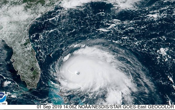

Hurricane Dorian Tropical Cyclone Update
NWS National Hurricane Center Miami FL AL052019
930 AM EDT Sun Sep 01 2019
...CATASTROPHIC CATEGORY 5 DORIAN CONTINUING TO INTENSIFY AS IT
APPROACHES THE ABACO ISLANDS...
Data from an Air Force Reserve Hurricane Hunter aircraft indicate
that Dorian has continued to intensify, and now has maximum
sustained winds near 175 mph (280 km/h), with a minimum central
pressure of 922 mb (27.23 inches).
I think we are going to have bad news at the 11:00 EDT update.
Then you are in a liberal sheethole. Much of Florida is paradise and is not “nasty”.
I think it’s looping now.Thanks DF.
Yeah, there’s no way that’s legit, it’s much worse there now than that video would indicate, in fact there’s no way you’re going to get a live video from there now.
Dear God how awful.
Am at work. Decisions very tricky.
http://www.floodmap.net/Elevation/CountryElevationMap/?ct=BS
Looks like a ridge running n/s near there. Hopefully they’ll head there if things get dicey.
re: DORIAN PATH OVER BAHAMAS
~~~~~~~~~~~~~~~~~~~~~~~~~~~~~~~~~
EXCERPT:
Another commenter posted a message from a Bahamian that reads, “I just can’t wait until the U.S. media and U.S. public wake up to the fact that their government (the Obama/Hillary/Kerry government) has permitted Red China to set up shop (including deep water stealth submarine operations) in the Bahamas only a few short miles away from Florida and the entire Eastern Seaboard. I imagine most Americans will want all senior officials of the U.S. embassy in the Bahamas, the Dept of State in the U.S. and the NSA over the past decade or so to be drawn and quartered for high treason because of their serious failure to gather and act on intelligence information in order to protect the national security interests of the U.S.”
180 mph now per Weather Channel. Moving W at 7 mph.
180 mph now per Weather Channel. Moving W at 7 mph.
Looks like nowhere high to get if the Edds guy is indeed in Hope Town.
Unbelievable! Prayers for all those people.......
Disclaimer: Opinions posted on Free Republic are those of the individual posters and do not necessarily represent the opinion of Free Republic or its management. All materials posted herein are protected by copyright law and the exemption for fair use of copyrighted works.