Posted on 08/13/2023 11:33:04 AM PDT by MtnClimber
With the approach of the [date removed to avoid confusion] hurricane season and the strong potential for El Niño to develop during the next few months, the effect that El Niño has on both the Atlantic and Pacific hurricanes seasons is worth exploring. The hurricane impacts of El Niño and its counterpart La Niña are like a see-saw between the Pacific and Atlantic oceans, strengthening hurricane activity in one region while weakening it in the other.
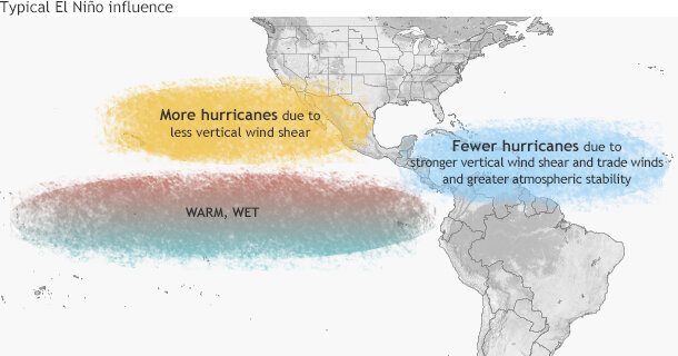
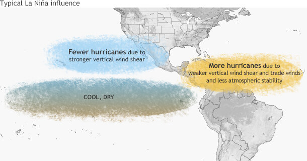
Simply put, El Niño favors stronger hurricane activity in the central and eastern Pacific basins, and suppresses it in the Atlantic basin (Figure 1). Conversely, La Niña suppresses hurricane activity in the central and eastern Pacific basins, and enhances it in the Atlantic basin (Figure 2).
These impacts are primarily caused by changes in the vertical wind shear, which refers to the change in wind speed and direction between roughly 5,000-35,000 ft. above the ground. Strong vertical wind shear can rip a developing hurricane apart, or even prevent it from forming.
ENSO perturbs tropical and subtropical atmospheric circulation During El Niño, the area of tropical Pacific convection and its associated Hadley circulation expand eastward from the western Pacific, sometimes extending to the west coast of South America. (A tutorial on El Niño and La Niña can be found at the NOAA Climate Prediction Center website.) At the same time, the equatorial Walker circulation is weaker than average.
These conditions produce an anomalous upper-level, ridge-trough pattern in the subtropics, with an amplified ridge over the subtropical Pacific in the area north of the enhanced convection, and a downstream trough over the Caribbean Sea and western tropical Atlantic. Over the central and eastern Pacific, the enhanced subtropical ridge is associated with weaker upper-level winds and reduced vertical wind shear, which favors more hurricane activity.
Over the Atlantic basin, the amplified trough is associated with stronger upper-level westerly winds and stronger lower-level easterly trade winds, both of which increase the vertical wind shear and suppress hurricane activity. In addition to enhanced vertical wind shear, El Niño suppresses Atlantic hurricane activity by increasing the amount of sinking motion and increasing the atmospheric stability.
La Niña has opposite impacts across the Pacific and Atlantic basins. During La Niña, the area of tropical convection and its Hadley circulation is retracted westward to the western Pacific and Indonesia, and the equatorial Walker circulation is enhanced. Convection is typically absent across the eastern half of the equatorial Pacific.
In the upper atmosphere, these conditions produce an amplified trough over the subtropical Pacific in the area north of the suppressed convection, and a downstream ridge over the Caribbean Sea and western tropical Atlantic. Over the central and eastern subtropical Pacific, the enhanced trough is associated with stronger upper-level winds and stronger vertical wind shear, which suppress hurricane activity. Over the Atlantic basin, the anomalous upper-level ridge is associated with weaker upper- and lower- level winds, both of which reduce the vertical wind shear and increased hurricane activity. La Niña also favors increased Atlantic hurricane activity by decreasing the amount of sinking motion and decreasing the atmospheric stability.
ENSO phases interact with other climate patterns that influence hurricanes Another prominent climate factor to influence Atlantic hurricane activity is the Atlantic Multi-Decadal Oscillation (AMO) (Goldenberg et al. 2001, Bell and Chelliah 2006). The warm phase of the AMO is associated with high-activity eras for Atlantic hurricanes, such as has been in place since 1995. Conversely, the cold phase of the AMO is associated with low-activity eras (such as the period 1971-1994).
The warm phase of the AMO reflects warmer SSTs across the Atlantic hurricane Main Development Region (MDR, Figure 3). A key atmospheric feature of this pattern is a stronger West African monsoon, which produces a westward extension of the upper-level easterly winds (near 35,000 ft), along with weaker easterly trade winds in the lower atmosphere (near 5,000 ft).
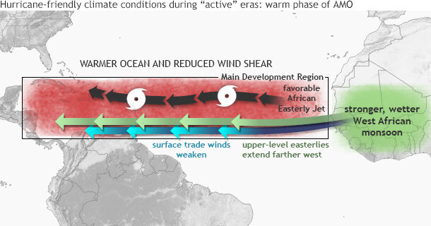
This wind pattern is very conducive to increased Atlantic hurricane activity, partly because it results in weaker vertical wind shear. The weaker trade winds also contribute to a more conducive structure (i.e. increased cyclonic shear) of the mid-level (near 10,000 ft) African Easterly Jet (AEJ), favoring hurricane development from tropical cloud systems (i.e. easterly waves) moving westward from Africa. At the same time, these wind patterns are associated with a more northward push into the MDR of deep tropical moisture and unstable air, each of which also favors stronger hurricanes.
The hurricane activity in a given season often reflects a combination of the multi-decadal signals and ENSO. During an Atlantic high-activity era, El Niño typically results in a near-normal season, and La Niña produces an above-normal season. During an Atlantic low-activity era, El Niño typically results in a below-normal season and La Niña results in a near-normal season (Bell and Chelliah 2006).
Similarly for the central and eastern Pacific basins, the combination of a low-activity era and El Niño often produces a near-normal season, while La Niña produces a below-normal season. For a Pacific high-activity era, El Niño often produces an above-normal season, while La Niña produces a near-normal season.
This year the expectation that El Niño will develop, combined with the multi-decadal climate signals results in a forecast for a near- or below-normal season in the Atlantic, and a near- or above-normal season in both the central and eastern Pacific. For more detail, check out NOAA’s 2014 Hurricane Season Outlook.
NOAA PRESS RELEASE
From NOAA 2023 Atlantic Hurricane Season Outlook
NOAA 2023 Atlantic Hurricane Season Outlook Issued: 10 Aug 2023 Realtime monitoring of tropical Atlantic conditions Realtime monitoring of tropical East Pacific conditions Atlantic Hurricane Outlook & Seasonal Climate Summary Archive The updated 2023 North Atlantic Hurricane Season Outlook is an official product of the National Oceanic and Atmospheric Administration (NOAA) Climate Prediction Center (CPC). The outlook is produced in collaboration with hurricane experts from NOAA’s National Hurricane Center (NHC) and Atlantic Oceanic and Meteorological Laboratory (AOML). The Atlantic hurricane region includes the North Atlantic Ocean, Caribbean Sea, and Gulf of Mexico.
Interpretation of NOAA's Atlantic hurricane season outlook: This outlook is a general guide to the expected overall activity during the upcoming hurricane season. It is not a seasonal hurricane landfall forecast, and it does not predict levels of activity for any particular location.
Preparedness: Hurricane-related disasters can occur during any season, regardless if the season is active or relatively quiet. It only takes one hurricane (or tropical storm) to cause a disaster. It is crucial that residents, businesses, and government agencies of coastal and near-coastal regions prepare for every hurricane season regardless of this, or any other, seasonal outlook. The Federal Emergency Management Agency (FEMA) through Ready.gov and Listo.gov, the National Hurricane Center, the Small Business Administration, and the American Red Cross all provide important hurricane preparedness information on their web sites.
NOAA does not make seasonal hurricane landfall predictions: NOAA does not make seasonal hurricane landfall predictions. Hurricane landfalls are largely determined by the weather patterns in place as the hurricane approaches, and those patterns are only predictable when the storm is within several days of making landfall.
Nature of this outlook and the "likely" ranges of activity: This outlook is probabilistic, meaning the stated “likely” ranges of activity have a certain likelihood of occurring. The seasonal activity is expected to fall within these ranges in 7 out of 10 seasons with similar climate conditions and uncertainties to those expected this year. They do not represent the total possible ranges of activity seen in past similar years.
This outlook is based on analyses of 1) predictions of large-scale climate factors known to influence seasonal hurricane activity, and 2) climate forecast models that directly predict seasonal hurricane activity. The outlook also takes into account uncertainties inherent in such climate outlooks.
Preparedness for tropical storm and hurricane landfalls: It only takes one storm hitting an area to cause a disaster, regardless of the overall activity for the season. Therefore, residents, businesses, and government agencies of coastal and near-coastal regions are urged to prepare every hurricane season regardless of this, or any other, seasonal outlook.
Sources of uncertainty in the seasonal outlooks: Predicting El Niño and La Niña events (also called the El Niño-Southern Oscillation, or ENSO) and their impacts on North Atlantic basin hurricane activity, is an ongoing scientific challenge facing scientists today. Such forecasts made during the spring generally have limited skill, but that skill increases during the summer. Specific to this outlook, the major sources of uncertainty are rooted in the interplay between the current El Niño and the conditions local to the North Atlantic. Many combinations of named storms, hurricanes, and major hurricanes can occur for the same general set of climate conditions. For example, one cannot know with certainty whether a given climate signal will be associated with several shorter-lived storms or fewer longer-lived storms with greater intensity. Model predictions of various factors known to influence seasonal hurricane activity in the Atlantic region, such as sea surface temperatures (SSTs), vertical wind shear, moisture, and atmospheric stability are still showing some spread for August-October (ASO), the peak months of the hurricane season, and it is unclear as to exactly how conducive these conditions will be for tropical cyclone development. Shorter-term weather patterns that are unpredictable on seasonal time scales can sometimes develop and last for weeks or months, possibly affecting seasonal hurricane activity. 2023 North Atlantic Hurricane Season Outlook Summary a. Predicted Activity
NOAA's updated outlook for the 2023 Atlantic Hurricane Season indicates that an above-normal season is most likely, with lower odds for a near- or below-normal season. The outlook calls for a 60% chance of an above-normal season, along with a 25% chance for a near-normal season and a 15% chance for a below-normal season. See NOAA definitions of above-, near-, and below-normal seasons. The Atlantic hurricane region includes the North Atlantic Ocean, Caribbean Sea, and Gulf of Mexico.
The updated 2023 outlook calls for a 70% probability for each of the following ranges of activity during the 2023 hurricane season, which officially runs from June 1st through November 30th: 14-21 Named Storms, which includes the 5 named storms recorded thus far in 2023. 6-11 Hurricanes, which includes the 1 hurricane recorded thus far in 2023. 2-5 Major Hurricanes Accumulated Cyclone Energy (ACE) range of 105%-200% of the median, which includes the ACE from the 5 named storms (1 of which reached hurricane strength) recorded thus far in 2023.
Not a great forecast for us on the Gulf and Atlantic coasts of North America.
Call me when the weather guys start talking about “El Hombre” and/or “La Mujer”.
I am not done clearing damage from two hurricanes in 2022.
Treasure Coast FL here observation. The local weather guys and gals really look stupid. No hurricanes so they only talk about “feels like” temperatures. LOL
Are you telling me that my cars air conditioning is not causing this?
I’ve read that once the dust in the Atlantic is gone, it’s game on b/c the El Nino shear isn’t going to be what was predicted and the Atlantic is a bathtub. CSU I think predicted this first.
She can talk about anything she wants.
If you vote "R" then yes, you are to blame. If you vote "D" then you are not the problem.
Good news for Florida ping.
Cue ‘chicken little’ science.
/s
Yowza whatever she says.
Now there’s “La Mujer”.
Yeah, there’s a “warm front” inside of my pants!
The El Nino is not shaping up like they thought it would. It is August so It could change, but it does not look good today.
That’s a “meteorologist” on a Mexican TV station??? Holy cow. Looks more like the beginning of a porn flick. Brazilian butt and all.
If she ate a bean burrito, that could start some bad weather!
Sounds like the Mexicans and their kids are the cause of all this “climate change” and weather stuff.
We are in an extreme drought in West Central Florida. We aren’t getting our summertime afternoon t-storms to cool things down. Needing a lot of rain before the dry season begins. Especially with our population explosion in Florida the past few years.

Disclaimer: Opinions posted on Free Republic are those of the individual posters and do not necessarily represent the opinion of Free Republic or its management. All materials posted herein are protected by copyright law and the exemption for fair use of copyrighted works.