
Posted on 04/22/2016 10:17:58 AM PDT by NYer
The Convention of 1818 between Britain and America following the War of 1812 had a tough job to take on: determining the border between Canada and the United States. In an effort to avoid controversy and confusion caused by drawing the boundary based on watershed, the two countries agreed on a simpler solution: the 49th parallel.
There were, of course, multiple problems that arose with this solution, including the fact that Vancouver Island was split in two by the imaginary line. The debate over whether the line of latitude should split the island in two or if it should be ignored, giving the full island to Canada, was known as The Oregon Boundary Dispute. In 1846 President James Polk proposed making Vancouver Island an island of two countries, therein designating more land to America, but this was immediately rejected by the British. In the end, the British and Americans agreed to give the entire Vancouver Island to Canada, while giving the San Juan Islands to the United States.
Problem solved, right? Not exactly. Due to limited knowledge of the region's geography at the time, there was one land area that both the Americans and the British failed to notice: The Tsawwassen Peninsula.
This peninsula was unknown at the time, but once discovered, it was too late. The agreement had accidently cut off a tiny piece of Canada and given it to the United States.
Nowadays, at the end of this peninsula, there is a little American town called Point Roberts, Washington. The only land route out of Point Roberts is through Canada. This town of over 1,000 people has a clinic, a police station, a fire department, a marina, and a primary school.
As a result of this geographic peculiarity the town has some strange habits. Every day, a large portion of the Canadians living just north travel across the border to buy groceries and gas, which are about a third cheaper in the U.S. It is said that Canadians will also travel over for the medium rare burgers, which are unheard of in Vancouver because of the strict Canadian health code. Point Roberts is also an unusually safe city: because of the border security, the crime rate of Point Roberts is over three times lower than that of Washington as a whole.
Despite all of these intriguing qualities, it seems that keeping this geographically isolated town in working order is remarkably difficult. The county that this town belongs to has been slow in providing it with adequate infrastructure, considering that it took two years to install a single streetlight. Business is slow, except for in the summer, when the residency quintuples due to Canadian tourism. There's no shoe store, no veterinarian, and no dentist. There also isn't a single school that serves students from grades 4-12. To access these things, it's necessary to cross the Canadian border to Tsawwassen, circle to White Rock, Canada, and finally cross the American border to Blaine, Washington. This trip is 40 minutes there, 40 minutes back, and it requires four borders to be crossed. For students who live in Point Roberts, the bus to Blaine High School leaves as early as 6:25am, which is before sunrise on most schooldays.
Regardless of the pros and cons, it is quite spectacular that places like these exist. It's a place that's almost as Canadian as it is American, where maple leaf flags fly high (the vast majority of boats in the marina are owned by Canadians). It's a place that is here by accident, by foolishness, a mistake that went unfixed. It also shows the ability of people to adapt, and to make this strange geographical exclave a livable home for over a thousand people.
We sailed over from Deer Harbor for groceries. Pete and Susan of San Juan Canvas in Friday Harbor helped us make new sails for our boat. We were there back in the early to mid ‘80’s.
Do you mean the ‘Pig War’?
That vicious American killer, Lyman Cutlar, shooting that poor, innocent pig! Cutlar, a name that will live in infamy! </sarc>
“Cold” from a So. Cal, Arizona perspective. I’m a warm-weather kind of guy.
Yes, you would find it cold. From what I’ve been told by a fellow FReeper from S. CA, he finds San Fransicko to be COLD in the winter. Point Roberts would be colder.
There most definitely IS a border crossing at Point Roberts. It’s staffed 24x7.
True story, not many years ago, I bought several five gallon gas cans to take advantage of my 30 gallon fill limit from those grocery store shopping discounts.
The American version of the nozzle is pictured below. It is a Rube Goldberg style contraption called an "Ëco Spout" which is designed to shut-off if you overfill. It works fine for a few uses and then starts leaking gasoline like a sieve.
I called the manufacturer to complain and, Canadians, being very nice people, sent me a new set at no charge. Everything goes fine for the next few uses, then same problem and I call them again.
The customer service lady then tells me that the sell a simple Canadian version which works on the basic principle of gravity flow without the Rube Goldberg style automatic shut-off. Great, I said, it is a stupid feature anyway because I don't use the can unless I know there is ample capacity in the tank. She tells me that unfortunately, they are not allowed to sell it or even ship it to the United States.
Do I have an opportunity to ever come to Canada to shop at Home Depot, Canadian Tire or any other of their retail distributors? I thank her for the idea, then start checking on-line. Long story short: I find somebody in Point Roberts who sells them for a very reasonable mark-up plus shipping.
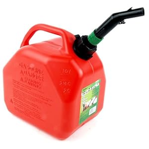 American version nozzle.
Canadian version nozzle source.
I suspect other states have similar geographic oddities.
Cool Post ! Thanks
Right. Only a few hundred people in the Northwest Angle, mostly because it is mostly Indian reservation which isn’t really business friendly.
I recall residents there being given the option of just joining Canada but turned it down.
Great fishing.
54-40 or fight? Oh, that was with Great Britain.
Users of that kind of transport are typically wealthy*. Doesn't sound like a wealth laden community to me. If it had profit potential, someone would be doing it.
*Compared to the average, that is.
Those currents are out in the ocean - Point Roberts on the Strait of Georgia in the Salish Sea. Even in the dead of winter water temps are in the mid 40s so it’s pretty mild, but during what are warm Summer days inland, it can still be cool near the water. What that area does get is Frazier River outflow when there’s high pressure east of the Cascades/Coast Range and very cold and dense Arctic air from the BC interior runs down the river valleys and into the Vancouver/Bellingham area (it’s the same situation with the Columbia in Portland). When it slides below a moist south-westerly from Hawaii there is the potential for damaging ice storms. Seattle is generally spared this due to the Puget Sound Convergence, where westerlies are split by the Olympic Range with half the winds coming down the Strait of Juan de Fuca and the other half coming up the Chehalis Gap. They generally meet north of Seattle and create a barrier to outflow from the northern interior. Although when the Alberta Clipper meets the Pineapple Express further to the west, there is the potential for heavy lowland snow throughout the Puget Sound region. Thus ends today’s lesson in Puget Sound weather.
Winters if SF can be pretty mild and Fall is outstanding. When I was kid we’ed go to a baseball game in mid-Summer in Candlestick are freeze our asses off. As Mark Twain didn’t actually say, “The coldest winter I ever spent was a summer in San Francisco.”
I realize it is just a little over 17 square miles but nobody can get from Kentucky Bend to any other part of Kentucky without passing through Tennessee or Missouri.
If it was richer than the surrounding area like Point Roberts, it would have reason to stay, but it obviously isn't judging by the stark contrast in roads.
check out St. Pierre and Michelon off of the maritime coast in Quebec. although only miles from Canada, both these islands belong to France.
It was 14 years ago, and maybe my memory has faded a bit, but I crossed over w/o incident of any type, and this was going both ways. Perhaps they just waived me through. I definitely was not stopped nor did I show a passport.
Here’s another one - in this case the line is only between the boroughs (counties) that make up New York City, but important to the residents, who are in an exclave of Manhattan instead of the Bronx. Marble Hill, New York, which was isolated from the island of Manhattan and connected to the Bronx by man-made changes in the watercourses separating the two Boroughs - https://en.wikipedia.org/wiki/Marble_Hill,_Manhattan#
Newfoundland, actually. They’re quite a ways from Quebec.
Disclaimer: Opinions posted on Free Republic are those of the individual posters and do not necessarily represent the opinion of Free Republic or its management. All materials posted herein are protected by copyright law and the exemption for fair use of copyrighted works.