Posted on 09/15/2020 9:44:54 AM PDT by BenLurkin
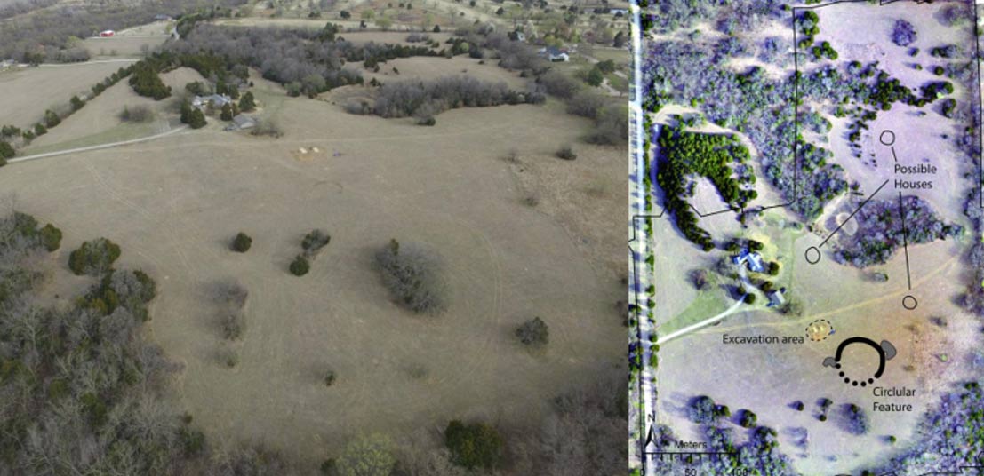
A new study by lead author Professor Jesse J. Casana, chair of the department of anthropology at Dartmouth College published in American Antiquity , says the team of archaeologists conducted their survey at a ranch located in the lower Walnut River valley. The author describes the local topography as flat, with no visible archaeological features. However, flying state of the art scanning equipment over this landscape located in present-day Arkansas City, Kansas, near the Arkansas River, revealed “an ancient, circular shaped ditch measuring 50 meters wide and approximately 2 meters thick”.
The scientists explain in their paper that as the soil eroded it filled up the circular ditch with different types of soils than the original mud, and this means the structure retained water differently, which the researchers say gives the site “unique thermal properties.” Furthermore, the water retention levels at the site also impacted vegetation because grass growth was more vigorous than other vegetation, and using “near-infrared imagery,” the team of scientists were able to identify areas that had been filled in at the Kansas earthwork.
The new method the professor referred to means working at night because archaeological features have fluctuating thermal effects and after the ground cools down at nighttime hidden features below ground level emit thermal infrared radiation, at different rates, which the researchers captured using drones. And with their high-resolution aerial data the team reproduced detailed thermal and multispectral imagery of the lost 18-hectare archaeological site.
(Excerpt) Read more at ancient-origins.net ...
Maybe it was a septic system.
I first used this thermal technology 35 years ago to measure the mechanical condition of aerator heads within 60 acres of aerated lagoons. I used it a second time 30 years ago to survey 1000 something miles of petroleum pipelines for locations that may have had historical spill contamination.
In other words, this technology has been around for some time. What is different is the radically decrease in cost and weight of the gear. For the lagoon application, a movie camera size sensor was mounted in a helicopter door on a gyro stabilized frame. A thick umbilical cable connected the sensor to a heavy battery pack and a computer. The pipeline project used similar equipment except it was smaller and lighter and was mounted in the open door of a Cessna.

Hmm... photos taken from drones operating at night over farmland. Sounds like the solution to another ‘mystery’ that had folks all loading their 12 gauges awhile back.
Thanks for the ping, even though the only thing he saved was the pea pods.

Good observation! My former business partner and I recorded a hunting blind of limestone within 75 meters of the entrance of Carlsbad Caverns, in New Mexico. The site had been missed be several preceeding surveys over a 50 year period.
Disclaimer: Opinions posted on Free Republic are those of the individual posters and do not necessarily represent the opinion of Free Republic or its management. All materials posted herein are protected by copyright law and the exemption for fair use of copyrighted works.
