Skip to comments.
Man spends life researching Lost Colony mystery
The Virginian-Pilot ^
| 17 Oct 2010
| Jeff Hampton
Posted on 10/17/2010 2:55:01 PM PDT by Palter
Sam Sumner retired as a schoolteacher, left his Hawaii home and recently moved to North Carolina, all for the purpose of solving the mystery of the Lost Colony.
The answer lies not in Buxton where experts and amateur sleuths have searched for decades, he says, but at Mackay Island National Wildlife Refuge in Currituck County, a site that leaves experts skeptical.
A 1923 map in the lobby of Mackay Island ranger station shows an image on the ground next to the Currituck Sound that looks just like an old drawing of Fort Raleigh.
"I looked at that map and I knew immediately what it was," Sumner said. "I have the evidence on my side. It is up to the archaeological experts to say the image is not a 16th-century fort."
Sumner, 63, has researched one of America's oldest mysteries for 31 years, traveling almost annually from Hawaii to Roanoke Island. He has partnered with a psychic archaeologist; rented underground radar equipment at budget-busting costs; queried experts; researched books, maps and papers; and written reports.
But the most compelling clue is the map.
Sir Walter Raleigh sent 118 colonists to the New World in 1587 to establish a settlement. Led by John White, they landed at what is now Roanoke Island.
In August 1587, White left for England to get supplies, returning in 1590 to find the colony gone. All he found were the letters CRO carved on a tree and CROATOAN carved on a post. The colony possibly split up, one group going south to Buxton on Hatteras Island where the Croatan Indians lived and the other north toward Chesapeake. White wrote that a group was to go 50 miles inland.
"There are two islands 50 miles away," Sumner said. "One is at Hatteras and one is Knotts Island."
The colonists lived there for 20 years, until 1607, when the Powhatan Indians massacred them, according to a history from 1612. That is another strong piece of evidence they were there, Sumner said.
Forts of that day were made of earth piled high after digging a ditch around the perimeter, said Doug Stover, historian at the Fort Raleigh National Historic Site on Roanoke Island.
The image on the map has a long nose at one end and is star-shaped at the other, just like the old, undocumented drawing used to show what Fort Raleigh may have looked like.
Sumner could seek help through Fort Raleigh if the evidence is strong enough, Stover said. Mackay Island will not issue Sumner a permit to excavate unless he has backing from a sanctioned archaeologist or group.
It is hard to get backing without more evidence and hard to get more evidence without excavating, Sumner said.
Lost Colony researchers do not give credence to his Mackay Island theory.
"We know of no archaeological evidence to indicate a Raleigh colony there," said Phil Evans, president of the First Colony Foundation, a group that researches the Raleigh colonization efforts.
The group would have settled in a place where the Indians were friendly, said Nick Luccketti, principal investigator at the James River Institute for Archaeology and a vice president of the First Colony Foundation.
"I'm not sure Knotts Island fits that bill," he said.
The Mackay Island site, called the Sumner site by Sumner, is now an oval shaped pond. Sumner believes the site, located in low lands, may have been dug out and filled with water for duck ponds.
Joseph Knapp, the wealthy owner of Mackay Island in the 1920s, hunted there and practiced waterfowl conservation.
"They're all looking at Buxton," Sumner said. "No one looks anywhere else."
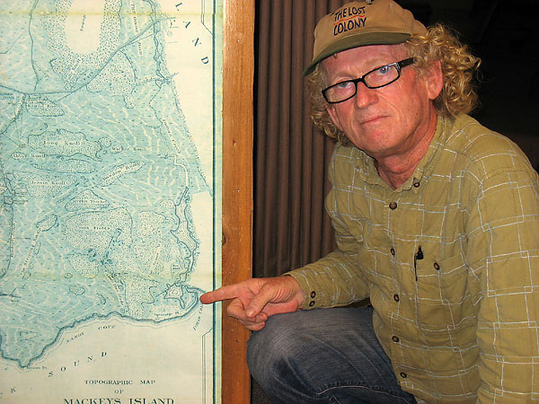
Sam Sumner believes the mystery of the Lost Colony can be solved by looking at Mackay Island National Wildlife Refuge in Currituck County. He points to the image on a 1923 map of the refuge that could be the remains of a fort built by members of the Lost Colony after they left Roanoke Island in 1587.
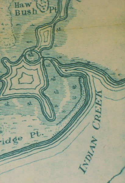
A closeup view of the image drawn on a 1923 map of Mackay Island National Wildlife Refuge that looks much like an old drawing of Fort Raleigh. Retired school teacher Sam Sumner believes this image helps solve the mystery of the Lost Colony.
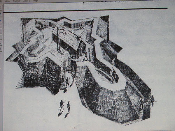
This old, undocumented drawing purportedly shows what Fort Raleigh may have looked like, a long nose at one end and star-shaped at the other, which matches the image on a 1923 map in the lobby of Mackay Island ranger station.
TOPICS: History
KEYWORDS: americanhistory; bertiecounty; croatoan; lostcolony; mystery; nicholasmluccketti; northcarolina; roanoke; sitex; virgineapars; virginia
Navigation: use the links below to view more comments.
first previous 1-20, 21-40, 41-60, 61 next last
To: Cathy
Somebody did that to make this ...
21
posted on
10/17/2010 3:21:04 PM PDT
by
BuckeyeTexan
(There are those that break and bend. I'm the other kind.)
To: BuckeyeTexan
That’s some real talent. Might want to lay off the fiber just a tad, though.
To: BuckeyeTexan
23
posted on
10/17/2010 3:39:53 PM PDT
by
Paladin2
To: Paladin2
It would be if that were my “art.”
24
posted on
10/17/2010 3:41:38 PM PDT
by
BuckeyeTexan
(There are those that break and bend. I'm the other kind.)
To: Palter
Wraiths of Roanoke
[SciFi movie]
25
posted on
10/17/2010 3:41:38 PM PDT
by
TomGuy
To: Rebelbase
The NC coast shits and moves continuously. That's pretty interesting, for shifts and giggles.
To: Rebelbase; Ryan Spock; TheMom; TChris; Xenalyte; Semper Vigilantis; georgiadevildog; ...
The NC coast shits and moves continuously. Typso ping! Geo-anthropomorphism ping, too. Don't eat those fish ...
27
posted on
10/17/2010 4:55:30 PM PDT
by
Tax-chick
(Be nice to venomous snakes. They only want to eat a mouse!)
To: Palter
First: that 'fort shaped' hill appears to be a pond. If the pond represents the moat around the fort then the fort's interior was below sea level.
Second: why would anyone build a fort with that shape? The Vauban touches are nice, but that long extension just increases the amount of wall to be defended without adding much to interior space.
28
posted on
10/17/2010 4:59:03 PM PDT
by
Grut
To: fieldmarshaldj
29
posted on
10/17/2010 5:02:47 PM PDT
by
Rebelbase
(Palin/Christie 2012)
To: Tax-chick
The NC coast shits and moves continuously. But isn't that redundant (aside from any geological difficulty)? Don't most people refer to, ah, that AS "having a movement"?
30
posted on
10/17/2010 5:10:47 PM PDT
by
Still Thinking
(Freedom is NOT a loophole!)
To: Still Thinking
31
posted on
10/17/2010 5:12:06 PM PDT
by
Tax-chick
(Be nice to venomous snakes. They only want to eat a mouse!)
To: Palter
The map shows the contours of a tidal pond.
32
posted on
10/17/2010 5:16:59 PM PDT
by
PAR35
To: RegulatorCountry
I am fascinated by the Melungeons. I wish I knew more. My paternal grandfather's family came from that part of the country, central Tennessee. He was sort of a strange looking man, dark hair, light eyes, tall and thin. He died at about 90+ and only had a couple of gray hairs in his head. I have always wondered if he was one of them but he died in about 1959 and I had never heard of Melungeons until a few years ago.
33
posted on
10/17/2010 5:36:16 PM PDT
by
Ditter
To: BuckeyeTexan
Around dinner time, not a good pic to post. ;/
34
posted on
10/17/2010 5:43:35 PM PDT
by
mojitojoe
(Caractacus..or Bob if a boy & Boudicca if a girl....such hard decisions for dearie Snidely)
To: Ditter
There is a genetic project or two going on, or was. Clues in behavior and speech, too. Sort of restless, moved a lot outside of their, what, strongholds in VA, TN and NC? Not sure if that’s the right word. So-called “shovel teeth” are a physical trait, claiming to be “Black Dutch” or “Portugee” would be a linguistic clue.
I’ve got a few genealogical lines with strong ties to the group, most notably Sizemore.
To: RegulatorCountry
I just Googled Melungeon, interesting. My grandfather was born in 1879 in Texas but his family came originally from Tennessee. He went back there to visit them a few times. It was his different looks that make me wonder about his ancestry. His last name was Copeland and I have never seen that name among Melungeon names. Wish I had asked him more questions before he died. Isn't it always that way?
36
posted on
10/17/2010 6:16:36 PM PDT
by
Ditter
To: mojitojoe
Class always tells. Lower class, too.
37
posted on
10/17/2010 6:21:23 PM PDT
by
LucyT
To: Ditter
In the South, Melungeons was often used to explain away the appearance of dark pigmentation within a White Southern Family. No matter the actual reason: genetic anomoly, French, Italian, Indian, or (heaven forbid) African; the Melungeon explanation was a way to avoid derogatory social gossip.
The truth is that the South was far more ethnically diverse than many of our dear sweet elderly Aunts were prepared to admit.
To: Ditter
Hit the Census records in TN; which counties matter. Census records and associated surnames are fairly easily located online these days. Neighbors’ names in the vicinity, too. They were isolated and even ostracized in the 1800’s, so being in the vicinity of a Melungeon community would likely tell you something.
And, how is little Cookie doing? Still better?
To: RJR_fan
The Lumbee have a history of assimilating other cultures. That area of NC was a haven for runaway indentured servants and later slaves, criminals and any other societal refugees that needed a place to live outside the mainstream of colonial society.
40
posted on
10/17/2010 6:43:53 PM PDT
by
Rebelbase
(Palin/Christie 2012)
Navigation: use the links below to view more comments.
first previous 1-20, 21-40, 41-60, 61 next last
Disclaimer:
Opinions posted on Free Republic are those of the individual
posters and do not necessarily represent the opinion of Free Republic or its
management. All materials posted herein are protected by copyright law and the
exemption for fair use of copyrighted works.
FreeRepublic.com is powered by software copyright 2000-2008 John Robinson