Skip to comments.
Experts solve mystery of ancient stone monument near Atlanta
Examiner ^
| 11 April 2011
| Richard Thornton
Posted on 04/12/2011 12:01:12 PM PDT by Palter
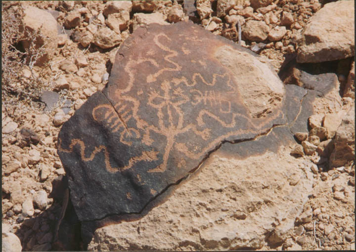
Rock art specialists from around North America have finally solved this century old archaeological riddle. The stone slab is evidence that native peoples from Puerto Rico or Cuba once lived within the interior of Eastern North America.
One day, long before Christopher Columbus claimed to have landed on the eastern edge of Asia, a forgotten people cut steps in the rocks leading up a steep bluff near the Chattahoochee River in the northwest section of the State of Georgia. They carved a supernatural figure on a four feet by one foot granite slab and erected it on the top of the knoll. The strange, primitive art was very different than the highly realistic stone sculptures found in the region that are known to have been created by the ancestors of Georgia’s Creek Indians.
During the mid-1800s a major industrial complex was developed near the ancient rock shrine. Somehow during the town’s construction, the tablet was overlooked; most likely because of a covering of soil. The town was called New Manchester. It would have inevitably become a major city of the Southeast, but in the autumn of 1864 the notorious Union general, William Tecumseh Sherman, ordered the town burned, and the hundreds of teenage girls who worked at its mills transported to a concentration camp in the Ohio. Many of the girls were never seen again. Some died in prison. Some married and stayed in the Midwest. Some were murdered while they tried to walk home after the war. Some probably went to the West to start life anew away from the ruins of war. Some just dissappeared without a trace.
The ruins of New Manchester have remained a testimony to the fact that war is hell.
(Excerpt) Read more at examiner.com ...
TOPICS: History
KEYWORDS: caribbean; cuba; ggg; godsgravesglyphs; petroglyph; puertorico; stones; worstexcerptever
Navigation: use the links below to view more comments.
first previous 1-20, 21-32 last
To: AppyPappy
Did your tank have carpet on the dash?
[Ducks, runs]
Nope! No carpet. Just pictures of the enemy on the dashboard and on the outside.
And, I'm pretty sure that, ducking and running would not have helped you against a few tank rounds, and for certain, not against a flame tank. ;)
BTW, I neither drove the tanks, nor did I fire the rounds. I ordered the firing of the rounds and the flames, so you had better be on my good side over there. ;)
21
posted on
04/12/2011 3:57:38 PM PDT
by
adorno
To: Palter; StayAt HomeMother; Ernest_at_the_Beach; 1010RD; 21twelve; 24Karet; 2ndDivisionVet; 31R1O; ..
22
posted on
04/12/2011 4:08:12 PM PDT
by
SunkenCiv
(Thanks Cincinna for this link -- http://www.friendsofitamar.org)
This might be up someone's alley, ESOP sent out courtesy copies of this to members back in 1983.
23
posted on
04/12/2011 4:13:30 PM PDT
by
SunkenCiv
(Thanks Cincinna for this link -- http://www.friendsofitamar.org)
To: Palter
It is very significant evidence that Native Americans originally from Puerto Rico, Cuba or Hispaniola paddled to the Florida Peninsula; followed the Gulf Coast up to the mouth of the Apalachicola-Chattahoochee River; then ulitimately settled in the vicinity of what is now Atlanta. How do they know it wasn't the other way around?
To: afraidfortherepublic
Being easterners, they forgot to look along the San Juan River and especially Sand Island for very similar male petroglyphs.
25
posted on
04/12/2011 4:30:17 PM PDT
by
bert
(K.E. N.P. N.C. D.E. +12 ....( History is a process, not an event ))
To: SunkenCiv
26
posted on
04/13/2011 6:29:25 AM PDT
by
AuH2ORepublican
(If a politician won't protect innocent babies, what makes you think that he'll protect your rights?)
To: AuH2ORepublican
Whatever Fell’s mistakes were here and there, he wasn’t a fraud. Anyone who says he was simply doesn’t know what they’re talking about.
27
posted on
04/14/2011 7:22:52 PM PDT
by
SunkenCiv
(Thanks Cincinna for this link -- http://www.friendsofitamar.org)
To: SunkenCiv
I know nothing about ancient Irish writing, but that rebuttal pointed out very convincingly that experts agreed that Fell’s claiks regarding the WV caves were completely illogical and without merit. From what I read, one would have to suspend disbelief to make Fell’s theory even plausible. There is some solud evidence of a pre-Columbian European presence in North America, but those cave etchings ain’t it.
28
posted on
04/15/2011 3:23:13 AM PDT
by
AuH2ORepublican
(If a politician won't protect innocent babies, what makes you think that he'll protect your rights?)
To: AuH2ORepublican
Fell was continually attacked by some people who are/were dead set against acceptance of PreColumbian voyages of any kind, yes: but the claims they made are “illogical and without merit”. The tone was set by “Archaeology” magazine, which called one of his books “a candidate for burning”.
29
posted on
04/15/2011 4:48:38 AM PDT
by
SunkenCiv
(Thanks Cincinna for this link -- http://www.friendsofitamar.org)
To: Palter
30
posted on
05/15/2011 10:10:56 PM PDT
by
Beowulf9
To: SunkenCiv; Palter
I live 7 miles from Sweetwater park. Grew up going there...went down it’s class three and four rapids(Was ignorant at the time)on an innertube when I was 16. At 45, I use a kayak.
Just found the article about the petroglyphs this past weekend.
This entire area was well populated with Mississipian peoples. Sweetwater, The Chattahoochie, Dog River, Annewake creek, and the etowah all hold artifacts. So does the flint down south. Not twenty odd miles north is the Etowah mound complex...which very closely resembles kolomoki in structure and artifacts.
I’d be very interested in hearing y’alls opinion. My non-professional, non-educated opinion is it is the work of peoples living here.
That section of Sweetwater is different and sacred. For most of it’s 45 mile length, Sweetwater creek is a slow moving ditch. Then, through it’s one mile run through the creek, it’s transformed into a wide, rocky, raging mountain river. Interestingly enough, the creek bed through the park is the exposed Brevard fault line, which marks the boundry between the end of hill country and the Appalachains.
31
posted on
11/17/2012 8:39:34 PM PST
by
Vigilantcitizen
(Dave Mustaine for president.)
To: Vigilantcitizen
32
posted on
11/19/2012 4:09:54 AM PST
by
SunkenCiv
(https://secure.freerepublic.com/donate/)
Navigation: use the links below to view more comments.
first previous 1-20, 21-32 last
Disclaimer:
Opinions posted on Free Republic are those of the individual
posters and do not necessarily represent the opinion of Free Republic or its
management. All materials posted herein are protected by copyright law and the
exemption for fair use of copyrighted works.
FreeRepublic.com is powered by software copyright 2000-2008 John Robinson