Free Republic
Browse · Search
News/Activism
Topics · Post Article

Skip to comments.

China map lays claim to Americas ( China Won't Stop at Taiwan?)
BBC NEWS ^ | Friday, 13 January 2006, 13:23 GMT | BBC NEWS (general staff)

Posted on 01/14/2006 7:34:00 AM PST by Candor7

China map lays claim to Americas

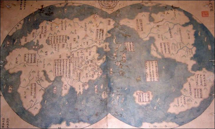
The map clearly shows the Americas and Africa

Image hosted by Photobucket.com

A map due to be unveiled in Beijing and London next week may lend weight to a theory a Chinese admiral discovered America before Christopher Columbus. The map, which shows North and South America, apparently states that it is a 1763 copy of another map made in 1418.

If true, it could imply Chinese mariners discovered and mapped America decades before Columbus' 1492 arrival.

The map, which is being dated to check it was made in 1763, faces a lot of scepticism from experts.

Chinese characters written beside the map say it was drawn by Mo Yi Tong and copied from a map made in the 16th year of the Emperor Yongle, or 1418.

It clearly shows Africa and Australia.

The British Isles, however, are not marked.

Controversial claim

The map was bought for about $500 from a Shanghai dealer in 2001 by a Chinese lawyer and collector, Liu Gang.

According to the Economist magazine, Mr Liu only became aware of the map's potential significance after he read a book by British author Gavin Menzies.

The book, 1421: The Year China discovered America, made the controversial claim that a Chinese admiral and eunuch, Zheng He, sailed around the world and discovered America on the way.

Zheng He, a Muslim mariner and explorer, is widely thought to have sailed around South East Asia and India, but the claim he visited America is hotly disputed.

The map is now being tested to check the age of its paper and ink, with the results due to be known in February.

Even if it does prove to have been drawn in 1763, sceptics will point out that we still only have the mapmaker's word that he copied if from a 1418 map, rather than from a more recent one.


TOPICS: News/Current Events
KEYWORDS: 1421; 1492; ageofsail; america; china; christophercolumbus; columbus; columbusday; commoncore; commoncorenavigation; discovery; gavinmenzies; godsgravesglyphs; navigation; precolumbus; yongle
Navigation: use the links below to view more comments.
first 1-2021-4041-6061-8081-99 next last
Well, China also invented the Internet along with Al Gore?

The discovery is probably true. The journals of Yongle have long been know to have recited the discovery of America.

Of course the support for this version of history comes from: MUSLIMS!

See realted site:

www.admiralzhenghe.org/

One more cultural incursion by Muslims and Chinese.

Egg foo yung in a Burqua!

1 posted on 01/14/2006 7:34:04 AM PST by Candor7
[ Post Reply | Private Reply | View Replies]

To: Candor7
Does this mean America is a Renegade Breakaway Province of China?
2 posted on 01/14/2006 7:37:17 AM PST by SandRat (Duty, Honor, Country. What else needs to be said?)
[ Post Reply | Private Reply | To 1 | View Replies]

To: Candor7
It doesn't matter. The Vikings discovered, landed and settled in North America long before 1421.

There's also evidence that Hebrews from a couple of thousand years ago (or more) landed and explored the Americas. The Egyptians, too. If the Chinese finally made it to the Americas in 1421, then it was about damn time.

3 posted on 01/14/2006 7:40:14 AM PST by xrp
[ Post Reply | Private Reply | To 1 | View Replies]

To: Candor7

It's not really difficult to believe that they sailed east and discovered the west coast of the Americas. But it's a lot harder to accept that they not only circumnavigated the globe but went up and down the coast of every contenent, sailed up the major rivers of every continent, pushed their way in wooden boats through the ice-clogged Northwest Passage that defied European ships for centuries, circumnavigated Antarctica and realized there was land beneath the ice, and charted the furthest, most snowbound portions of Russia.


4 posted on 01/14/2006 7:41:25 AM PST by Capriole (I don't have any problems that can't be solved by more chocolate or more ammunition.)
[ Post Reply | Private Reply | To 1 | View Replies]

To: Candor7
Boy...... look, they were seers.

California is out in the Pacific Ocean.

Bye, bye Babs!

5 posted on 01/14/2006 7:41:27 AM PST by beyond the sea ("If someone is callin' you from Al Queda, we want to know why.")
[ Post Reply | Private Reply | To 1 | View Replies]

To: Candor7
It's possible and that would have been quite a feat of seamanship.

Followed the Vikings by 400 years.

6 posted on 01/14/2006 7:42:15 AM PST by Mike Darancette (Mesocons for Rice '08)
[ Post Reply | Private Reply | To 1 | View Replies]

To: Candor7

No wonder New Orleans flooded. The Mississippi ended before it got to the Gulf.


7 posted on 01/14/2006 7:43:25 AM PST by beyond the sea ("If someone is callin' you from Al Queda, we want to know why.")
[ Post Reply | Private Reply | To 1 | View Replies]

To: SandRat
Does this mean America is a Renegade Breakaway Province of China?

Looks like California broke away.

8 posted on 01/14/2006 7:44:14 AM PST by beyond the sea ("If someone is callin' you from Al Queda, we want to know why.")
[ Post Reply | Private Reply | To 2 | View Replies]

To: Candor7

Unfortuantely for them, they won't even get Tawain.


9 posted on 01/14/2006 7:46:14 AM PST by pissant
[ Post Reply | Private Reply | To 1 | View Replies]

To: Candor7
Zheng He, a Muslim mariner and explorer, ...

Oy vey

10 posted on 01/14/2006 7:46:36 AM PST by JoeSixPack1
[ Post Reply | Private Reply | To 1 | View Replies]

To: Candor7

Patton and McArthur were right on...


11 posted on 01/14/2006 7:47:21 AM PST by joesnuffy (A camel once bit our sister.. but we knew what to do.. we gathered rocks and squashed her!)
[ Post Reply | Private Reply | To 1 | View Replies]

To: Candor7

the map is not the territory...


12 posted on 01/14/2006 7:50:22 AM PST by chilepepper (The map is not the territory -- Alfred Korzybski)
[ Post Reply | Private Reply | To 1 | View Replies]

To: xrp
There's also evidence that Hebrews from a couple of thousand years ago (or more) landed and explored the Americas. The Egyptians, too.

The Egyptians had ships which were more than capable, better, in fact, than those available to Columbus. They also had astronomical knowledge which would have aided in navigation, and some believe they had a form of reverse osmosis to obtain fresh water from the sea. But the Hebrews? What evidence is there that they even had the technology for such a feat?

13 posted on 01/14/2006 7:53:09 AM PST by Jeff Chandler (Peace Begins in the Womb)
[ Post Reply | Private Reply | To 3 | View Replies]

To: Mike Darancette
They didn't just discover America. From that map they were also the first to observe that the Earth was round, and the first to explore the entire coastline of every major continent on earth. It would have been an enormous logistical effort of decades involving a major flotilla of ships, a very advanced system of navigation, the development of the kind of sophisticated timepieces that wouldn't be known by the west for centuries. It's amazing that none of the ships logs, the navigation system, or the highly valuable timepieces survive; but then again, neither did the numerous land based staging areas required to water, service, and feed such a far flung fleet.
14 posted on 01/14/2006 7:53:43 AM PST by ARCADIA (Abuse of power comes as no surprise)
[ Post Reply | Private Reply | To 6 | View Replies]

To: chilepepper

This map is very suspect. China has a reputation for forging everything from art to missing link fossiles. This is just an attempt to rewrite our history in a dangerous way. It is interesting that the explorer was muslim. Is this an attempt to motivate the US Muslims to fight for the return of their holy land in the Americas? I read somewhere that this version is being taught heavily in the mosques in Mexico. I will try and find a link for it.


15 posted on 01/14/2006 7:58:20 AM PST by willyd (No nation has ever taxed its citizens into prosperity)
[ Post Reply | Private Reply | To 12 | View Replies]

To: beyond the sea
They clearly explored the land area to map out the course of major rivers and the location of inland mountain ranges. Then again the chinese probably had satellite technology during the 14th century. [read: the map is a sloppy crock. It is like looking at an inscription that dates itself "300 BC"]
16 posted on 01/14/2006 7:59:56 AM PST by ARCADIA (Abuse of power comes as no surprise)
[ Post Reply | Private Reply | To 7 | View Replies]

To: Candor7

Why do people need to hold on to the belief that Columbus was the one and only explorer?


17 posted on 01/14/2006 8:00:22 AM PST by mtbopfuyn (Legality does not dictate morality... Lavin)
[ Post Reply | Private Reply | To 1 | View Replies]

Comment #18 Removed by Moderator

To: beyond the sea

Hmmm. Looks like they sailed into 'Frisco Bay and sailed down into the flooded San Joaquin Valley. Much of the Valley did flood before dams were built, but I don't know if there was enough water to sail a vessel through.


19 posted on 01/14/2006 8:03:37 AM PST by wizr
[ Post Reply | Private Reply | To 5 | View Replies]

To: Capriole

Exactly. My thought also. That amount of sailing and exploring would have been very, very difficult in those days. I think it's fake.


20 posted on 01/14/2006 8:05:52 AM PST by garyhope (Happy, healthy, prosperous New Year to all good Freepers and our brave military.)
[ Post Reply | Private Reply | To 4 | View Replies]


Navigation: use the links below to view more comments.
first 1-2021-4041-6061-8081-99 next last

Disclaimer: Opinions posted on Free Republic are those of the individual posters and do not necessarily represent the opinion of Free Republic or its management. All materials posted herein are protected by copyright law and the exemption for fair use of copyrighted works.

Free Republic
Browse · Search
News/Activism
Topics · Post Article

FreeRepublic, LLC, PO BOX 9771, FRESNO, CA 93794
FreeRepublic.com is powered by software copyright 2000-2008 John Robinson