Skip to comments.
Super Cool Shuttle Photo
rushlimbaugh.com ^
| 03/04/03
| Rush Limbaugh
Posted on 03/04/2003 9:52:26 PM PST by Pokey78
This is the most incredible photo. It was taken from the shuttle Columbia on its last mission and relayed by satellite, which is why we have it. What you see is the sunset in western Europe. There are no clouds in this picture. You can see much of Africa, all of western Europe, half of it at nighttime because the sun has set, the other half in broad daylight. You can clearly see Great Britain, Scotland, the British Isles, Spain, the Sahara desert. It's an amazing photo, folks.

TOPICS: Culture/Society; Extended News; Government; News/Current Events
KEYWORDS:
Navigation: use the links below to view more comments.
first 1-20, 21-40, 41-60, 61-80, 81-93 next last
Just incredible.
1
posted on
03/04/2003 9:52:26 PM PST
by
Pokey78
To: Pokey78
Great picture!
2
posted on
03/04/2003 9:56:48 PM PST
by
MEG33
bttt
3
posted on
03/04/2003 9:57:25 PM PST
by
1rudeboy
To: Pokey78
The sunset looks like God's shoulder.
4
posted on
03/04/2003 9:58:17 PM PST
by
Slyfox
To: Pokey78
Obviously fake.
5
posted on
03/04/2003 9:59:04 PM PST
by
Henk
To: Pokey78
Wow!
6
posted on
03/04/2003 9:59:28 PM PST
by
MHGinTN
(If you can read this, you've had life support from someone. Promote Life Support for others.)
To: petuniasevan
Thought you might find this interesting!!
7
posted on
03/04/2003 10:00:32 PM PST
by
trussell
(No FReeping while sleeping)
To: Pokey78
wow
8
posted on
03/04/2003 10:01:18 PM PST
by
paul51
To: Pokey78
I love photos from Space.
This is a neat one.
To: Pokey78
That is obviously a computer composite image.
Think about it...
hint: Look at the bottom of the Atlantic ocean.
10
posted on
03/04/2003 10:03:43 PM PST
by
Hunble
To: Pokey78
That's a very pretty picture, but it couldn't possibly have been taken from ANY shuttle. It represents about a 5000 mile dimension and the shuttles are at best about 200 miles high. Therefore the field of view of the lens would be about 170 degrees and the "fish eye" distortion would be extreme, not to mention that much of the included surface detail would be over the shuttles visible horizon at that height.
This picture is obviously from a much greater height -- like a geo-synch satellite at 22,300 miles.
11
posted on
03/04/2003 10:05:15 PM PST
by
jlogajan
To: Henk
Looks weird to me as well. How can the shadow line have such a sudden curve to the right???
12
posted on
03/04/2003 10:05:41 PM PST
by
JoJo Gunn
(Help control the Leftist population. Have them spayed or neutered....)
To: Pokey78
Beautiful picture.
How can anyone look at that and not believe in a creator, God?
13
posted on
03/04/2003 10:10:20 PM PST
by
A CA Guy
(God Bless America, God bless and keep safe our fighting men and women.)
To: JoJo Gunn
Looks weird to me as well. How can the shadow line have such a sudden curve to the right??? Wow, cool! You can see the continental shelf, hundreds of feet below the surface of the ocean,... hey, you can even see the Marianas Trench which is over 10000 feet deep! Holy cow those shuttle cameras are good!
Actually that curve of shadow to the right is probably one of the few authentic things in the photo. Gee, ya mean Rush Limbaugh didn't do any fact checking - could it be??
14
posted on
03/04/2003 10:12:35 PM PST
by
clamboat
To: clamboat
(and in case it is lost on anyone, it's a joke. This is a cool composite, but I don't think it is a real photo. Besides which the Marianas Trench is really on another ocea entirely.)
15
posted on
03/04/2003 10:14:40 PM PST
by
clamboat
To: Pokey78
It doesnt look real, you cant see the curvature of the earth, it looks like a map.
16
posted on
03/04/2003 10:15:51 PM PST
by
Husker24
To: Pokey78
IBesides being a composite, it looks like the summertime. The North pole would be in light and that doesn't happen on February 1.
17
posted on
03/04/2003 10:18:08 PM PST
by
Wacka
To: Pokey78
That double 'S' running down the center of the Atlantic looks like the mid-Atlantic plate subduction zone.
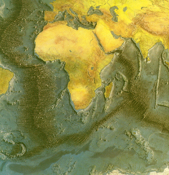
Amazing that what took oceanographers and geologists so long to map from ocean floor spreading studies is so visible in one shuttle photo.
18
posted on
03/04/2003 10:20:00 PM PST
by
Starwind
To: Pokey78
Looks like a fake hoss .... not a single cloud in the sky as well.
19
posted on
03/04/2003 10:20:51 PM PST
by
Centurion2000
(Take charge of your destiny, or someone else will)
To: JoJo Gunn
How can the shadow line have such a sudden curve to the right??? That would be consistent with a Lambert Conformal Conic projection - hence a map.
20
posted on
03/04/2003 10:22:11 PM PST
by
jlogajan
Navigation: use the links below to view more comments.
first 1-20, 21-40, 41-60, 61-80, 81-93 next last
Disclaimer:
Opinions posted on Free Republic are those of the individual
posters and do not necessarily represent the opinion of Free Republic or its
management. All materials posted herein are protected by copyright law and the
exemption for fair use of copyrighted works.
FreeRepublic.com is powered by software copyright 2000-2008 John Robinson