Posted on 09/28/2022 11:24:51 AM PDT by Red Badger
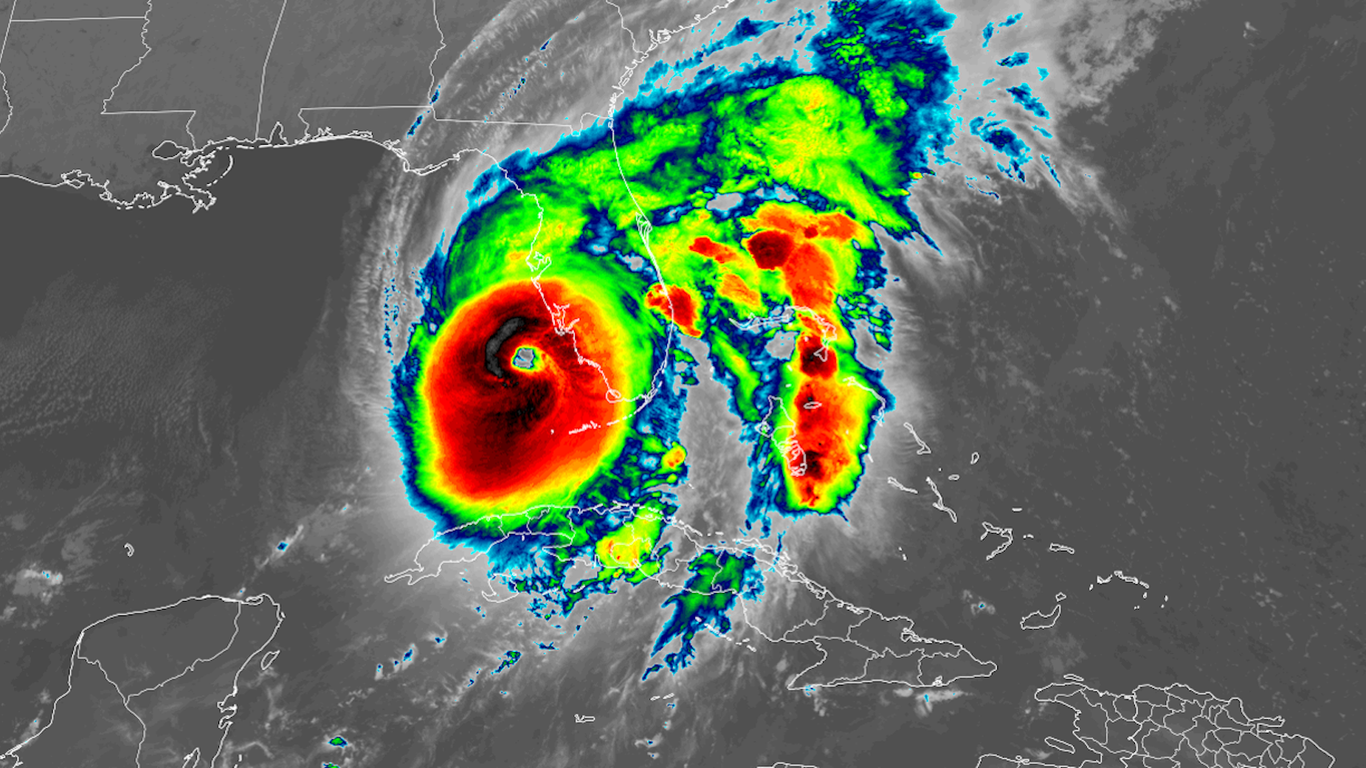
Hurricane Ian satellite photo Image: NOAA
An intensifying Hurricane Ian is on the cusp of becoming a Category 5 storm as it nears landfall along Florida's west coast with "catastrophic" winds and storm surge flooding Wednesday afternoon, per the National Hurricane Center.
State of play: The Category 4 hurricane is packing maximum sustained winds of 155 mph, the NHC said. That's just 2 mph shy of Category 5 intensity.
Just four hurricanes have made landfall in the U.S. with maximum sustained winds greater than 155 mph, according to Philip Klotzbach, a researcher at Colorado State University.
As of 1pm Wednesday, the center of Hurricane Ian was located 45 miles west-southwest of Punta Gorda, Florida, and was moving north-northeast at 9 mph, packing 155 mph winds.
The major storm unleashed life-threatening storm surge flooding across the lower Florida Keys overnight. It's doing the same on the Florida mainland — including the highest surge levels on record in Naples, Florida. Ft. Myers, Sanibel Island and Cape Coral were also seeing damaging flooding as of midday. Water has pushed inland in some communities.
The Hurricane Center increased storm surge forecasts Wednesday morning to as high as 18 feet in parts of southwest Florida, including Charlotte Harbor and Bonita Beach.
This would be unprecedented there, and on par with some of the country's highest surge events in history. What they're saying: Florida Gov. Ron DeSantis said at a briefing Wednesday morning that Ian is "a major, major storm. ... The strengthening of this over the last night has been really, really significant."
MAP AT LINK..........
Data: National Hurricane Center; Map: Jared Whalen/Axios
What to expect: The center of Ian is expected to move across the west coast of Florida during early afternoon, then cross central Florida through Thursday morning and reemerge over water northeast of Florida by Thursday morning.
Hurricane-force winds are possible along the east-central Florida coast, the NHC stated.
Potentially "catastrophic" flooding was forecast with widespread rainfall amounts of up to 18 inches across much of the state, per the National Weather Service.
The Weather Service has issued a rare "high risk" outlook for flash flooding for much of the state.
Power outages are starting to occur in the state, with more than 304,000 without electricity, according to PowerOutage.us. That number is expected to rise.
More than 2,000 flights into, within or out of the U.S. were canceled as of mid-morning Wednesday, according to flight tracking website FlightAware.
Tampa
The city is likely to see a far lower storm surge, on the order of 4 to 6 feet, than areas to the south, due to the storm's track.
Axios Local dispatch, via Ben Montgomery: The approaching storm and a falling tide began emptying the shallows of the Hillsborough River, Old Hillsborough Bay and parts of Upper Tampa Bay Wednesday morning.
Along Tampa's Bayshore Boulevard, the water had retreated from the seawall about 50 feet in places, like it did when Hurricane Irma streaked east of the region in 2017.
Flashback: Hurricane Ian was taking a path similar to that of Hurricane Charley in 2004, which caused $14 billion (in 2004 dollars) in damage. However, Ian is a far larger storm, bringing a greater surge and broader wind field.
Threat level
What we're watching: One of the biggest threats is storm surge flooding at the coast, which prompted mandatory evacuations in many areas.
A storm surge warning was in effect for a heavily populated stretch of coastline that includes Tampa Bay, Fort Myers, Naples, Port Charlotte, St. Petersburg and Sarasota.
The NHC called surge heights "potentially historic," and warned that certain locations may be "uninhabitable for an extended period."
Lightning strikes were observed in the thunderstorms surrounding the eye, a sign of continued intensification through landfall. Devastating wind damage is occurring where the core of the storm moves ashore and barrels inland.
Climate change-related sea level rise is making surge-related flooding more damaging.
Georgia
Storm surge watches, tropical storm watches and warnings, and hurricane watches have been issued extending up and down the east coast of Florida into Georgia and south Carolina.
This is due to the storm's expected track after Florida.
Climate change context
Context: Hurricane Ian has been rapidly intensifying over extremely warm sea surface temperatures straight through landfall.
Climate change favors more instances of rapidly intensifying storms such as Hurricane Ian, due to the combination of warming seas and a warmer atmosphere that can carry additional amounts of water vapor.
The bottom line: Florida is experiencing a historic storm that could cause billions in damage.
Editor's note: This is a developing story. Please check back for updates throughout the day.
Context: Hurricane Ian has been rapidly intensifying over extremely warm sea surface temperatures straight through landfall.
Wow. Is this unprecedented? Have we ever seen a hurricane intensify over warm sea surface temperatures before? At this time of year? Asking for a friend.
When all you have is a chainsaw, everything looks like a tree....................
It wasn’t unprecedented in Houston.
Have I mentioned being glad I don’t live there anymore?
In listening to the storm chaser dude on YouTube, highest confirmed wind gust is 123 mph at Captiva. It is not 155 mph sustained.
I am right on the predicted path, but away from the coast (Winter Haven, FL). It is already raining and blowing like hell. Rain total forecasts in the 12-24 inch range. I just moved back to FL after over 20 years in Colorado so I don’t know how badly the post-hurricane turns into looterville.
Is it true ?
The stronger the winds of a hurricane are, the less the storm is likely to follow man’s predicted path ?
iow — man’s path prediction is based on adjacent high pressure and if the storm goes even lower in pressure then all bets are off ?
I was in a worse predicted path until a few days ago. Zip 33523 Dade City seems to be on the ‘cleaner’ side now.
There are so many variables involved that nobody can say for certain where any storm is going past 24 hours.
That’s why the probability ‘cone’ is so wide. They just average all the different computer spaghetti models and then make the call................
It might be at the eye wall.
I’m in the eyewall.
It is a bad storm.
The eye is easily visible on radar. It is just west of Fort Myers and is headed towards Punts Gorda and Port Charlotte. Unless it stalls and turns. Movement is very slow.
Everyone run for your lives from the thunderstorm!
You can listen in to Amateur Radio hurricane net on Websdr.org
20 meters 14.235
Just choose North America and find a portal with a lot of listeners.
I know Dade City. I hope it misses you, but it is so big that you will still get damaging rain/wind. It is getting increasingly worse here. Visibility here is very low, 200 yards and sometimes less.
My German Shepherd may not give me time to shoot looters.
My error freq is 14.325
You’re not terribly far from Plant City.
I’ve been watching a webcam there right by the rail depot. Ben there a few times to watch trains. Have travelled thru Dade City as well.
Just a lot of rain and wind. Nothing near as bad as down towards Punta Gorda, etc.
Disclaimer: Opinions posted on Free Republic are those of the individual posters and do not necessarily represent the opinion of Free Republic or its management. All materials posted herein are protected by copyright law and the exemption for fair use of copyrighted works.