Skip to comments.
NASA Data Peers into Greenland’s Ice Sheet
NASA's Goddard Space Flight Center, Greenbelt, Maryland ^
| January 23, 2015, updated August 7, 2017
| George Hale, ed by Holly Zell
Posted on 08/29/2021 8:58:17 PM PDT by SunkenCiv
This new map allows scientists to determine the age of large swaths of Greenland’s ice, extending ice core data for a better picture of the ice sheet’s history. “This new, huge data volume records how the ice sheet evolved and how it’s flowing today,” said Joe MacGregor, a glaciologist at The University of Texas at Austin’s Institute for Geophysics and the study’s lead author.
Greenland’s ice sheet is the second largest mass of ice on Earth, containing enough water to raise ocean levels by about 20 feet. The ice sheet has been losing mass over the past two decades and warming temperatures will mean more losses for Greenland. Scientists are studying ice from different climate periods in the past to better understand how the ice sheet might respond in the future.
One way of studying this distant past is with ice cores. These cylinders of ice drilled from the ice sheet hold evidence of past snow accumulation and temperature and contain impurities like dust and volcanic ash that were carried by snow that accumulated and compacted over hundreds of thousands of years. These layers are visible in ice cores and can be detected with ice-penetrating radar.
Ice-penetrating radar works by sending radar signals into the ice and recording the strength and return time of reflected signals. From those signals, scientists can detect the ice surface, sub-ice bedrock and layers within the ice.
New techniques used in this study allowed scientists to efficiently pick out these layers in radar data. Prior studies had mapped internal layers, but not at the scale made possible by these newer, faster methods. Another major factor in this study was the amount of Greenland IceBridge has measured.
(Excerpt) Read more at nasa.gov ...
TOPICS: Astronomy; Science
KEYWORDS: astronomy; catastrophism; globalwarminghoax; greenland; greennewdeal; science
Navigation: use the links below to view more comments.
first 1-20, 21-24 next last
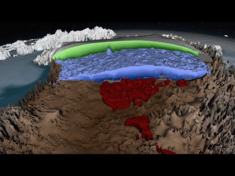
Peering into the thousands of frozen layers inside Greenland’s ice sheet is like looking back in time. Each layer provides a record of not only snowfall and melting events, but what the Earth’s climate was like at the dawn of civilization, or during the last ice age, or during an ancient period of warmth similar to the one we are experiencing today. Using radar data from NASA’s Operation IceBridge, scientists have built the first-ever comprehensive map of the layers deep inside the ice sheet.NASA | Greenland's Ice Layers Mapped in 3D | January 23, 2015 | NASA Goddard
1
posted on
08/29/2021 8:58:17 PM PDT
by
SunkenCiv
To: 75thOVI; Abathar; agrace; aimhigh; Alice in Wonderland; AnalogReigns; AndrewC; aragorn; ...
2
posted on
08/29/2021 8:58:52 PM PDT
by
SunkenCiv
(Imagine an imaginary menagerie manager imagining managing an imaginary menagerie.)
To: SunkenCiv
“...containing enough water to raise ocean levels by about 20 feet...”
-
I need to see the math before I believe that.
3
posted on
08/29/2021 9:01:12 PM PDT
by
Repeal The 17th
(Get out of the matrix and get a real life.)
To: SunkenCiv
Wait. Hasn’t the ice all melted?
4
posted on
08/29/2021 9:20:35 PM PDT
by
lurk
( )
To: SunkenCiv
5
posted on
08/29/2021 9:27:11 PM PDT
by
NetAddicted
( Just looking)
To: Repeal The 17th
So they think it’s floating just like Guam? 20 ft ?
STFU
6
posted on
08/29/2021 9:27:23 PM PDT
by
chiller
(Davey Crockett said: "Be sure you're right. Then go ahead'. I'm going ahead.)
To: SunkenCiv
So the Greenland ice-sheet has been losing mass. No sheet!
To: SunkenCiv
29 Aug: Climate Depot: Marc Morano: Scientists rip UN IPCC report: MIT’s Dr. Richard Lindzen: ‘Demonizing CO2 is just crazy’…’Ignore the climate crisis’ — Dr. Nir Shaviv of Hebrew U.: ‘They’re totally missing fact that the sun has a big effect on climate’
MIT Climate Scientists Dr. Richard Lindzen: When asked his opinion of Israeli solutions to climate change, Lindzen said: “Solution implies there is a problem.” The real question is if the plan’s worth doing. To that, he replied: “Not at all.” “Demonizing carbon dioxide is just crazy,” said [MIT climate scientist Richard] Lindzen. “It means we have a population that’s forgotten elementary biology. They don’t remember photosynthesis. We’ve already benefited due to the increase in CO2 by probably over a trillion dollars increase in agricultural productivity. The earth is greening due to this.”
Nir Shaviv, a professor of physics at Hebrew University, told JNS that he feels many climate scientists are under pressure to produce alarming reports. There is “such a large climate industry that people need to publish things that show a large effect [from man-made emissions], or they don’t get grants,” he explained. Shaviv said the IPCC’s scientists are not looking at all the evidence. “The thing that they’re totally missing is the fact that the sun has a big effect on climate. We can simulate it in large-scale simulations.” Shaviv: “So I’m totally confident after 20 years that the link is there, the sun has a large effect on climate.”...
https://www.climatedepot.com/2021/08/29/scientists-rip-un-ipcc-report-mits-dr-richard-lindzen-demonizing-co2-is-just-crazy-ignore-the-climate-crisis-dr-nir-shaviv-of-hebrew-u-theyre-totally-missing-fact-that-the-sun/
8
posted on
08/29/2021 9:31:27 PM PDT
by
MAGAthon
To: SunkenCiv
As with most “studies,” it just sounds like a boondoggle. Throw in a few words about globull warming.
To: SunkenCiv
The ice sheet has enough water to raise ocean levels by 20 feet.
It has been losing mass over the past two decades.
Ocean levels are the same as 20 years ago.
Something doesn’t add up.
To: Telepathic Intruder
It would all have to be in the atmosphere. Which kind of defies the water cycle, unless the atmosphere is a hell of a lot warmer than it was 20 years ago.
11
posted on
08/29/2021 10:10:52 PM PDT
by
gundog
(It was a bright cold day in April, and the clocks were striking thirteen. )
To: Repeal The 17th
Just doing it quickly...and not necessarily without error....it would take an ice sheet of 1,000 meters thickness covering Greenland’s area to raise the area currently covered by the world’s oceans 20 feet. I see a figure of 2-3,000 meters...real precise, I know...for the thickness of Greenland’s ice sheet. I have no idea how much land area would be flooded. but it must be pretty substantial.
12
posted on
08/29/2021 10:21:51 PM PDT
by
gundog
(It was a bright cold day in April, and the clocks were striking thirteen. )
To: SunkenCiv
Prolly going to use the imagery for their next global ‘we are doomed in 9.5 years’ climate change propaganda release...../s
13
posted on
08/29/2021 10:27:34 PM PDT
by
cranked
To: SunkenCiv
In the image from the video :
Green is ice laid down in the present geological age - the Holocene
Blue is from the Last Ice Age
Red is from the Eemian (130,000-115,000 BC)
14
posted on
08/30/2021 4:32:15 AM PDT
by
PIF
(They came for me and mine ... now its your turn)
To: Telepathic Intruder
Ocean levels are the same as 20 years ago.
Something doesn’t add up.
—
Only if you leave out the Antarctic ...
15
posted on
08/30/2021 4:33:26 AM PDT
by
PIF
(They came for me and mine ... now its your turn)
To: Repeal The 17th
That’s pure climate change BS propaganda. That amount of ice is like an ice cube in a bathtub.
Unfortunately.. the believers will say NASA says so.
16
posted on
08/30/2021 4:43:54 AM PDT
by
maddog55
(The only thing systemic in America is the left's hatred of it!)
To: Repeal The 17th
Numbers are from web searches and rounded.
Area of Greenland ice sheet 660235 Sq Mi.
Average thickness of Greenland ice sheet 0.95 Mi
Ice volume 660238 Sq Mi x 0.95 Mi = 627223 Cu Mi
Density convert ice to water 627223 Cu Mi x 0.9 = 564500 Cu Mi
Area of earths oceans 1.4 x10(8) Sq Mi
Sea level rise 564500 / 1.4 x10(8) = 0.004 Mi
Mi to feet 0.004 Mi =21 Ft
That would be a vertical rise, that does not take into account sloped shore lines and water level rise in river deltas, so the ocean rise would be less. Some one else needs to figure that out.
To: Telepathic Intruder
Heh, y'think? The Greenland keyword has one, or a few, topics about how many gigatons of ice have accumulated in a short time frame. Inland areas that are below sealevel (Qattara Depression and some other spots in Africa, California's Death Valley and Salton Sea, etc) could become the world's flood prevention basins. The Dead Sea is on the list of course, but flooding that would also drown the Galilee, and beside agriculture, there's plenty of economic activity in those parts. Also, the geographic barriers on both ends are something like 600 meters high.
18
posted on
08/30/2021 7:34:39 AM PDT
by
SunkenCiv
(Imagine an imaginary menagerie manager imagining managing an imaginary menagerie.)
To: maddog55
That ice is sitting on top of a land mass. It isn’t floating.
19
posted on
08/30/2021 7:57:11 AM PDT
by
GingisK
To: GingisK
I’ll stand by my metaphor..
20
posted on
08/30/2021 8:04:56 AM PDT
by
maddog55
(The only thing systemic in America is the left's hatred of it!)
Navigation: use the links below to view more comments.
first 1-20, 21-24 next last
Disclaimer:
Opinions posted on Free Republic are those of the individual
posters and do not necessarily represent the opinion of Free Republic or its
management. All materials posted herein are protected by copyright law and the
exemption for fair use of copyrighted works.
FreeRepublic.com is powered by software copyright 2000-2008 John Robinson