Free Republic
Browse · Search
Bloggers & Personal
Topics · Post Article

Skip to comments.

Open Access Maps at New York Public Library (20,000+ cartographic works free download)
NYPL ^ | March 28, 2014

Posted on 04/06/2014 4:17:50 AM PDT by NYer

The Lionel Pincus & Princess Firyal Map Division is very proud to announce the release of more than 20,000 cartographic works as high resolution downloads. We believe these maps have no known US copyright restrictions.* To the extent that some jurisdictions grant NYPL an additional copyright in the digital reproductions of these maps, NYPL is distributing these images under a Creative Commons CC0 1.0 Universal Public Domain Dedication. The maps can be viewed through the New York Public Library’s Digital Collections page, and downloaded (!), through the Map Warper. First, create an account, then click a map title and go. Here’s a primer and more extended blog post on the warper.

Plan of Bay Ridge Parkway, Olmsted, Olmsted & Eliot Landscape Architects, 1895 What’s this all mean?

It means you can have the maps, all of them if you want, for free, in high resolution. We’ve scanned them to enable their use in the broadest possible ways by the largest number of people.

Though not required, if you’d like to credit the New York Public Library, please use the following text "From The Lionel Pincus & Princess Firyal Map Division, The New York Public Library.” Doing so helps us track what happens when we release collections like this to the public for free under really relaxed and open terms. We believe our collections inspire all kinds of creativity, innovation and discovery, things the NYPL holds very dear.
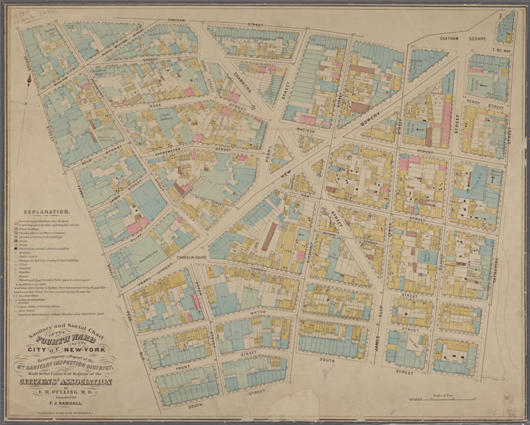

Sanitary and social chart of the Fourth Ward of the City of New York, to accompany a report of the 4th Sanitary Inspection District. 1864
A little background on how we got here… We’ve been scanning maps for about 15 years, both as part of the NYPL’s general work but mostly through grant funded projects like the 2001 National Endowment for the Humanities (NEH) funded American Shores: Maps of the MidAtlantic to 1850, the 2004 Institute of Museum and Library Services (IMLS) funded Building a Globally Distributed Historical Sheet Map Set and the 2010 NEH funded New York City Historical GIS.

Through these projects, we’ve built up a great collection of: 1,100 maps of the Mid-Atlantic United States and cities from the 16th to 19th centuries, mostly drawn from the Lawrence H. Slaughter Collection; a detailed collection of more than 700 topographic maps of the Austro-Hungarian empire created between 1877 and 1914; a collection of 2,800 maps from state, county and city atlases (mostly New York and New Jersey); a huge collection of more than 10,300 maps from property, zoning, topographic, but mostly fire insurance atlases of New York City dating from 1852 to 1922; and an incredibly diverse collection of more than 1,000 maps of New York City, its boroughs and neighborhoods, dating from 1660 to 1922, which detail transportation, vice, real estate development, urban renewal, industrial development and pollution, political geography among many, many other things.

We in the Map Division are all very excited about this release and look forward to seeing these maps in works of art, historical publications, movies, archaeological reports, novels, environmental remediation efforts, urban planning studies and more… Enjoy!

* The maps may be subject to rights of privacy, rights of publicity and other restrictions. It is your responsibility to make sure that you respect these rights.


TOPICS: Arts/Photography; History; Reference; Society
KEYWORDS: brooklyn; cartography; epigraphyandlanguage; godsgravesglyphs; maps; newyork; newyorkcity
Navigation: use the links below to view more comments.
first previous 1-2021-36 last
To: NYer

bump


21 posted on 04/06/2014 6:58:23 AM PDT by Skooz (Gabba Gabba we accept you we accept you one of us Gabba Gabba we accept you we accept you one of us)
[ Post Reply | Private Reply | To 1 | View Replies]

To: NYer
One of the very first sites I ever went to on the internet was a cartographic site. It was a gopher site, but you could download maps. (I think via anonymous ftp)

I used to have a map that was drawn in the late 1850s that showed railways nationwide. It was fascinating at the time, because I worked for MCI, and this hundred+ year old map lined up really well against our fiber routes at the time. It's not really surprising given how right-of-way works, but I still thought it was cool.

22 posted on 04/06/2014 11:58:33 AM PDT by zeugma (Don't cry because it's over, smile because it happened - Dr. Seuss (I'll see you again someday Hope))
[ Post Reply | Private Reply | To 1 | View Replies]

To: NYer; StayAt HomeMother; Ernest_at_the_Beach; decimon; 1010RD; 21twelve; 24Karet; 2ndDivisionVet; ..
Thanks NYer.
...you can have the maps, all of them if you want, for free, in high resolution.


23 posted on 04/07/2014 9:12:52 AM PDT by SunkenCiv (https://secure.freerepublic.com/donate/)
[ Post Reply | Private Reply | View Replies]

To: Kartographer

This just begs for someone to ping you...


24 posted on 04/07/2014 9:17:42 AM PDT by null and void (Politics: Voting for the monkeys that are better at flinging poo at their opponents...)
[ Post Reply | Private Reply | To 1 | View Replies]

To: NYer

Thanks for posting this.


25 posted on 04/07/2014 9:25:04 AM PDT by sauropod (Fat Bottomed Girl: "What difference, at this point, does it make?")
[ Post Reply | Private Reply | To 1 | View Replies]

To: NYer; FreedomPoster

The university of texas has 40,000 or so maps online for free

http://www.lib.utexas.edu/maps/

Perry-Castañeda Library
Map Collection


26 posted on 04/07/2014 10:08:39 AM PDT by bert ((K.E. N.P. N.C. +12 ..... History is a process, not an event)
[ Post Reply | Private Reply | To 2 | View Replies]

To: null and void

I was just checking to see if someone else had done that otherwise I would have.


27 posted on 04/07/2014 10:20:24 AM PDT by Cold Heart
[ Post Reply | Private Reply | To 24 | View Replies]

To: NYer

Love it! Thanks for posting.


28 posted on 04/07/2014 10:22:28 AM PDT by Jane Long (While Marxists continue the fundamental transformation of the USA, progressive RINOs assist!)
[ Post Reply | Private Reply | To 2 | View Replies]

To: bert

Thanks for that info ;)


29 posted on 04/07/2014 10:23:00 AM PDT by Jane Long (While Marxists continue the fundamental transformation of the USA, progressive RINOs assist!)
[ Post Reply | Private Reply | To 26 | View Replies]

To: bert

Thanks.


30 posted on 04/07/2014 10:32:24 AM PDT by FreedomPoster (Islam delenda est)
[ Post Reply | Private Reply | To 26 | View Replies]

To: NYer; SunkenCiv

I don’t dare go there. I am a map person and if I went in I would never come out.


31 posted on 04/07/2014 1:22:38 PM PDT by colorado tanker
[ Post Reply | Private Reply | To 1 | View Replies]

To: bert
Thank you for the link!

When I opened this thread the first thing I did was search the site for Historical Texas maps. No Republic of Texas maps, but they had a couple old Texas maps.

Then I saw your link to the University of Texas map archive... BINGO!

I am going to spend some time in thar.

32 posted on 04/07/2014 2:28:12 PM PDT by GregoTX (Remember the Alamo)
[ Post Reply | Private Reply | To 26 | View Replies]

To: colorado tanker

mapaholics anonymous needed here too..
“Intervention!”


33 posted on 04/07/2014 2:38:53 PM PDT by Squidpup ("Fight the Good Fight of Faith")
[ Post Reply | Private Reply | To 31 | View Replies]

To: NYer

Here is another interesting sight for different maps of all sorts

http://bigthink.com/blogs/strange-maps


34 posted on 04/07/2014 2:49:21 PM PDT by Lurkina.n.Learnin
[ Post Reply | Private Reply | To 1 | View Replies]

To: GregoTX

I asked them about a map Friday and zap...... there it was in my in box this morning

A’int Texas Great?


35 posted on 04/07/2014 3:25:01 PM PDT by bert ((K.E. N.P. N.C. +12 ..... History is a process, not an event)
[ Post Reply | Private Reply | To 32 | View Replies]

To: colorado tanker

Then you’d become a legend. /rimshot


36 posted on 04/07/2014 5:26:28 PM PDT by SunkenCiv (https://secure.freerepublic.com/donate/)
[ Post Reply | Private Reply | To 31 | View Replies]


Navigation: use the links below to view more comments.
first previous 1-2021-36 last

Disclaimer: Opinions posted on Free Republic are those of the individual posters and do not necessarily represent the opinion of Free Republic or its management. All materials posted herein are protected by copyright law and the exemption for fair use of copyrighted works.

Free Republic
Browse · Search
Bloggers & Personal
Topics · Post Article

FreeRepublic, LLC, PO BOX 9771, FRESNO, CA 93794
FreeRepublic.com is powered by software copyright 2000-2008 John Robinson