Posted on 07/22/2004 10:25:27 PM PDT by uglybiker
|
Rare photo of a rogue wave
|
Mariners who survived similar encounters have had remarkable stories to tell. In February 1995 the cruiser liner Queen Elizabeth II met a 29-metre high rogue wave during a hurricane in the North Atlantic that Captain Ronald Warwick described as "a great wall of water… it looked as if we were going into the White Cliffs of Dover."
And within the week between February and March 2001 two hardened tourist cruisers – the Bremen and the Caledonian Star – had their bridge windows smashed by 30-metre rogue waves in the South Atlantic, the former ship left drifting without navigation or propulsion for a period of two hours.
|
|||
|
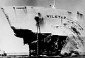
Damage done by a rogue wave
|
"The same phenomenon could have sunk many less lucky vessels: two large ships sink every week on average, but the cause is never studied to the same detail as an air crash. It simply gets put down to 'bad weather'."
Offshore platforms have also been struck: on 1 January 1995 the Draupner oil rig in the North Sea was hit by a wave whose height was measured by an onboard laser device at 26 metres, with the highest waves around it reaching 12 metres.
|
|||
|
Giant wave in Bay of Biscay
|
The fact that rogue waves actually take place relatively frequently had major safety and economic implications, since current ships and offshore platforms are built to withstand maximum wave heights of only 15 metres.
In December 2000 the European Union initiated a scientific project called MaxWave to confirm the widespread occurrence of rogue waves, model how they occur and consider their implications for ship and offshore structure design criteria. And as part of MaxWave, data from ESA's ERS radar satellites were first used to carry out a global rogue wave census.
|
|||
|
ERS satellite
|
ESA's twin spacecraft ERS-1 and 2 – launched in July 1991 and April 1995 respectively – both have a Synthetic Aperture Radar (SAR) as their main instrument.
The SAR works in several different modes; while over the ocean it works in wave mode, acquiring 10 by 5 km 'imagettes' of the sea surface every 200 km.
|
|||
|
Example of an imagette from ERS-2
|
"The raw imagettes are not made available, but with their resolution of ten metres we believed they contained a wealth of useful information by themselves," said Rosenthal. "Ocean wave spectra provide mean sea state data but imagettes depict the individual wave heights including the extremes we were interested in.
"ESA provided us with three weeks' worth of data – around 30,000 separate imagettes – selected around the time that the Bremen and Caledonian Star were struck. The images were processed and automatically searched for extreme waves at the German Aerospace Centre (DLR)."
|
|||
|
Giant wave detected in ERS-2 imagette data
|
"Having proved they existed, in higher numbers than anyone expected, the next step is to analyse if they can be forecasted," Rosenthal added. "MaxWave formally concluded at the end of last year although two lines of work are carrying on from it – one is to improve ship design by learning how ships are sunk, and the other is to examine more satellite data with a view to analysing if forecasting is possible."
A new research project called WaveAtlas will use two years worth of ERS imagettes to create a worldwide atlas of rogue wave events and carry out statistical analyses. The Principal Investigator is Susanne Lehner, Associate Professor in the Division of Applied Marine Physics at the University of Miami, who also worked on MaxWave while at DLR, with Rosental a co-investigator on the project.
"Only radar satellites can provide the truly global data sampling needed for statistical analysis of the oceans, because they can see through clouds and darkness, unlike their optical counterparts. In stormy weather, radar images are thus the only relevant information available."
So far some patterns have already been found. Rogue waves are often associated with sites where ordinary waves encounter ocean currents and eddies. The strength of the current concentrates the wave energy, forming larger waves – Lehner compares it to an optical lens, concentrating energy in a small area.
|
|||
|
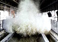
Giant wave in a wave tank
|
However the data show rogue waves also occur well away from currents, often occurring in the vicinity of weather fronts and lows. Sustained winds from long-lived storms exceeding 12 hours may enlarge waves moving at an optimum speed in sync with the wind – too quickly and they'd move ahead of the storm and dissipate, too slowly and they would fall behind.
"We know some of the reasons for the rogue waves, but we do not know them all," Rosenthal concluded. The WaveAtlas project is scheduled to continue until the first quarter of 2005.
PING
Bummer, I already hate flying and now giant waves! I guess I'll have to walk everywhere.
I had no idea.
Great find UB. BTTT.
Or Rosie O'Donnell, or Linda Ronstadt, or Margaret Cho, or......
Wonder what would happen if a major earthquake coincided with adverse weather, currents and eddies.
Bush's fault.
Sandy Berger inadvertently stuffed a rougue wave inside his pants.
"Rogue" waves? Which means that the UN won't do anything about them.
With one exception;
Thomas Gold
He seems to a bit ahead of the pack in understanding;
THE DEEP HOT BIOSPHERE
Read his books!
harmonics
A young officer was on the bridge scanning the horizon with binocculars.......I asked what he was looking for as we were 100's, if not 1000's of miles from nothing in the central Pacific. The radar techs in CiC would alert us to any approaching vessels.
And he told me about the "great waves" that have been dismissed by science throughout the modern era. Enormous, fast moving and not necessarily parallel to the surrounding seas. They sometimes appear suddenly. Sailors have known of them for ever. This statement received concurrance from the XO who was also on the bridge and it started me looking into it.
About 3-4 years later, on another ship (USS Benjamin Stoddert) we just skirted (about 60 deg vs 90) an 80 foot wave in stormy seas in the NW Pacific. The surrounding sea-state averaged 20-25 feet. I saw BLUE WATER smash over the bow and into the bridge before it broke white. That white water splashed us on the signal bridge.
Of course that DDG just sliced on through..........minus many antenae, a boat and most of everything else not below decks. It's an amazing sight if you live to tell about it:)
I just saw this on Drudge and had to save it to my "archives".
We ran into a really big,,maybe rouge wave out on the New England banks. The wave shattered the bridge glass on the ship(DD-765 Keppler) and took most everything off the bow..lifelines, stantions etc. It moved Mount 52 back about 18" and opened a smile in the deck which got the Chief's quarters very wet. We lost all power, the gyro tumbled. The bridge height was 45ft. above the water line.
Here's the latest big quake in Japan:
|
A strong earthquake occurred at 09:45:17 (UTC) on Thursday, July 22, 2004. The magnitude 6.2 event has been located in the RYUKYU ISLANDS, JAPAN. (This event has been reviewed by a seismologist.)
|


Disclaimer: Opinions posted on Free Republic are those of the individual posters and do not necessarily represent the opinion of Free Republic or its management. All materials posted herein are protected by copyright law and the exemption for fair use of copyrighted works.