Skip to comments.
Hurricane Katrina Live Thread, Part VIII
NOAA - NHC ^
| 29 August 2005
| NOAA - NHC
Posted on 08/29/2005 2:47:45 AM PDT by NautiNurse
Category 4 Hurricane Katrina is approaching landfall in Eastern Louisiana. At 4:00AM EDT the storm's center was about 90 miles south of New Orleans.
The following links are self-updating:
Public Advisory Currently published every 3 hours 5A, 8A, 11A, 2P, etc. ET
NHC Discussion Published every six hours 6A, 11A, 6P, 11P
Three Day Forecast Track
Five Day Forecast Track
Navy Storm Track
Katrina Track Forecast Archive Nice loop of each NHC forecast track for both three and five day
Forecast Models
Alternate Hurricane Models via Skeetobite
Bouy Data Louisiana/Mississippi
Buoy Data Florida
Lake Ponchartrain Real Time Water Level
Wind Speed Data
Images:
New Orleans/Baton Rouge Experimental Radar Subject to delays and outages - and well worth the wait
Mobile Long Range Radar Loop
New Orleans/Baton Rouge Radar
Ft. Polk, LA Long Range Radar Loop
Northwest Florida Long Range Radar
Storm Floater IR Loop
Storm Floater Still & Loop Options
Color Enhanced IR Loop
Other Resources:
Hurricane Wind Risk Very informative tables showing inland wind potential by hurricane strength and forward motion
Central Florida Hurricane Center
New Orleans Web Cams Loads of web cam sites here. The sites have been very slow due to high traffic
New Orleans Music Online Couldn't resist--love that jazz
Golden Triangle Weather Page Nice Beaumont weather site with lots of tracks and graphics
Hurricane City
Crown Weather Tropical Website Offers a variety of storm info, with some nice track graphics
Live streaming:
Cut and Paste:
http://www.wwltv.com/perl/common/video/wmPlayer.pl?title=beloint_khou&props=livenoad
Fully-linked version of the live feeds (just in case a few people don't want to first open up WMP to cut-and-paste) -
WWL-TV/DT New Orleans (WMP) - mms://beloint.wm.llnwd.net/beloint_wwltv
WVTM-TV/DT Birmingham (WMP) - mms://a1256.l1289835255.c12898.g.lm.akamaistream.net/D/
1256/12898/v0001/reflector:35255
WDSU-TV/DT New Orleans (WMP) - http://mfile.akamai.com/12912/live/reflector:38202.asx
Hurricane City (Real Player) - http://hurricanecity.com/live.ram
ABCNews Now (Real Player) - http://reallive.stream.aol.com/ramgen/redundant/abc/now_hi.rm
WKRG-TV/DT
Mobile (WMP) - mms://wmbcast.mgeneral.speedera.net/wmbcast
.mgeneral/wmbcast_mgeneral_aug262005_1435_95518 WDSU-TV/DT New Orleans via WESH-TV/DT Orlando - http://mfile.akamai.com/12912/live/reflector:38843.asx
Hurricane Katrina Live Thread, Part VII
Hurricane Katrina Live Thread, Part VI
Hurricane Katrina Live Thread, Part V
Hurricane Katrina, Live Thread, Part IV
Hurricane Katrina Live Thread, Part III
Katrina Live Thread, Part II
Hurricane Katrina Live Thread, Part I
Tropical Storm 12
| Category |
Wind Speed |
Barometric Pressure |
Storm Surge |
Damage Potential |
Tropical
Depression |
< 39 mph
< 34 kts |
|
|
Minimal |
Tropical
Storm |
39 - 73 mph
34 - 63 kts |
|
|
Minimal |
Hurricane 1
(Weak) |
74 - 95 mph
64 - 82 kts |
28.94" or more
980.02 mb or more |
4.0' - 5.0'
1.2 m - 1.5 m |
Minimal damage to vegetation |
Hurricane 2
(Moderate) |
96 - 110 mph
83 - 95 kts |
28.50" - 28.93"
965.12 mb - 979.68 mb |
6.0' - 8.0'
1.8 m - 2.4 m |
Moderate damage to houses |
Hurricane 3
(Strong) |
111 - 130 mph
96 - 112 kts |
27.91" - 28.49"
945.14 mb - 964.78 mb |
9.0' - 12.0'
2.7 m - 3.7 m |
Extensive damage to small buildings |
Hurricane 4
(Very strong) |
131 - 155 mph
113 - 135 kts |
27.17" - 27.90"
920.08 mb - 944.80 mb |
13.0' - 18.0'
3.9 m - 5.5 m |
Extreme structural damage |
Hurricane 5
(Devastating) |
Greater than 155 mph
Greater than 135 kts |
Less than 27.17"
Less than 920.08 mb |
Greater than 18.0'
Greater than 5.5m |
Catastrophic building failures possible |
TOPICS: News/Current Events; US: Alabama; US: Florida; US: Louisiana; US: Mississippi
KEYWORDS: hurricane; hurricanekatrina; katrina; tropical; weather
Navigation: use the links below to view more comments.
first previous 1-20 ... 3,821-3,840, 3,841-3,860, 3,861-3,880 ... 4,241-4,248 next last
To: Trident/Delta
That's why I said people who are grabbing survival supplies aren't really "looters". And I'm having trouble picturing anyone grabbing a stereo and swimming down the 10 foot deep street with it. If I saw anyone doing that, I'd assume s/he had sustained a head injury and wasn't thinking clearly. What does one do with a stereo that's been soaked through with muddy floodwater? And where would one take it under these circumstances?
To: monday
I'll join that FReeper in giving praise to God.
So that makes two of us at least.
3,842
posted on
08/29/2005 12:50:26 PM PDT
by
BenLurkin
(O beautiful for patriot dream - that sees beyond the years)
To: NautiNurse
Has anybody heard anything out of Thibodaux or Covington, La.? My parents live in the first (they are in NY this week) and I have other relatives in Covington.
To: Abigail Adams
See responses 3424, 3439, 3441 and 3468, among others, for information about Biloxi and Gulfport.
You can also try their
newspaper and
ABC affiliate for news. Someone else in another reponse posted a link to Southern Mississippi bloggers, but I don't have it.
To: Marysecretary
It saw him. It just didn't care.
To: Knitting A Conundrum
Yeah... me too. The fact that details are slow getting out from there is a very bad sign.
3,846
posted on
08/29/2005 12:51:21 PM PDT
by
Types_with_Fist
(I'm on FReep so often that when I read an article at another site I scroll down for the comments.)
To: monday
You don't think they rationalize to justify they are stealing? Interesting. I never thought of a looter have a conscience.
To: Johnny Crab
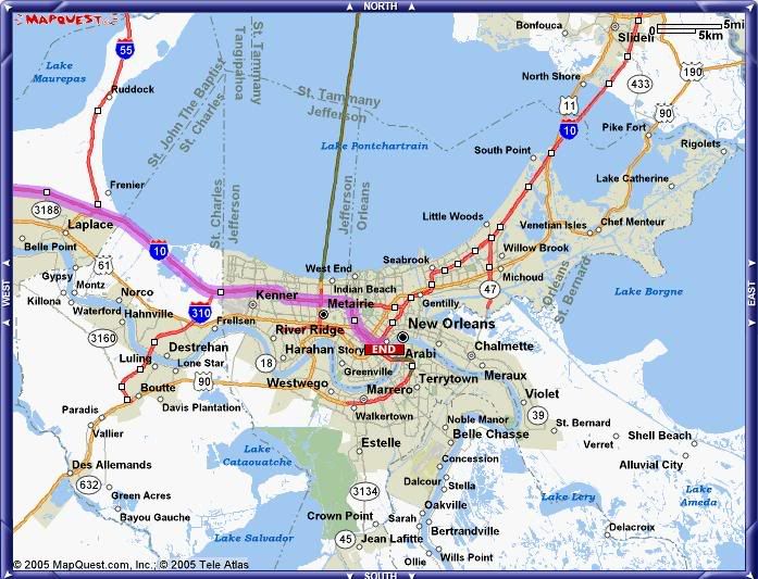
Good map, I'm going to repost it and provide some references for those not familiar with the area.
For those who look closely, you'll see a faint blue line that is the Industrial Canal running north/south on the east side of New Orleans. Starts under the name "Seabrook", runs just west of the name "Gentilly" and joins the Mississippi River just south of the 'N' in "New Orleans". Running east/west just north of "Gentilly" from Lake Borgne in the east to the Industrial Canal is the Intercoastal Waterway. These 2 canals divide the city into 3 sections, each of which have their own levee system. So basically the NO area north of the Mississippi River is 3 bowls.
To the west of the Industrial Canal is the biggest, containing downtown New Orleans and further west Metarie and Kenner. So far it appears that none of the levees were overtopped, and the flooding is mainly rainwater confined to the lowest spots.
The smallest bowl is to the southeast, containing Arabi and Chalmette. The Miss. River rose high enough to overtop the levee, and so far it appears that this bowl filled to as much as 12' deep. This is the area where the water to the rooftop shots are from, and apparently where several casualties are. This area may have gotten the catastrophic storm surge flooding that was feared for the rest of the city. It was closer to the eye and full surge force than downtown.
Haven't heard much from the northeast bowl, but there were earlier some reports that an area of the levee along Lake Pontchartrain was (at least briefly) overtopped.
Other points of reference: Jefferson Parish is the area on the south side of the Miss. River from NO. Slidell is across the lake in the northest corner of the map. The hurricane made landfall several miles east of Slidell, just to the east of the map's edge, which is roughly the MS/LA border. Covington is just north of the map, where the causeway bridge reaches the north shore of Lake Pontchartrain(the green line.)
To: Abigail Adams
wind, rain probably some tornado action for the whole state of TN. The whole state will be covered by this system, so Tennessians better gear up.
3,849
posted on
08/29/2005 12:51:39 PM PDT
by
SunnySide
(Ephes2:8 ByGraceYou'veBeenSavedThruFaithAGiftOfGodSoNoOneCanBoast)
To: fooman
Man they will have a hard time to do an evac next time, unless the storm is tracking due west AND is a 5. They can just show them pictures of what this storm did to people 30 miles away. And that's with the drop to Cat 4 at the last minute. New Orleans could have been a disaster...
3,850
posted on
08/29/2005 12:51:59 PM PDT
by
RobFromGa
(Afghanistan, Iraq, Iran-- what are we waiting for?)
To: Gone GF
Yeah, but if I added that in, the tagline wouldn't fit. :)
}:-)4
3,851
posted on
08/29/2005 12:52:20 PM PDT
by
Moose4
(Richmond, Virginia, where our motto is "Will Riot For Cheap Laptops")
To: SunnySide
Obviously this was an unsafe vehicle design.
Call Ralph Nader & Joan Claybrook & Brian O'Neil and a good class action law firm.
Any good minivan should be able to withstand a crash like that with no injury.
To: SunnySide
I swear yesterday right before her outer bands touched the shoreline, she had a perfect circle for an eye and she looked like a friggin' buzz saw. Gave me chills down my spine.
To: deport
Would these bodies if just dead be floating this quick?That's a fair question. But I don't know that embalmed corpses float any better than fresh ones.
As usual after a disaster, hard facts are in short supply.
To: BenLurkin
Me too...loss of property is sad, but the fact that most people got out early enough to avoid death from the storm. WE should feel thankful that we have the technology to know where the storms are coming in and the means for large parts of the people affected had a chance to get to a safer location.
3,855
posted on
08/29/2005 12:52:38 PM PDT
by
Knitting A Conundrum
(Act Justly, Love Mercy, and Walk Humbly With God Micah 6:8)
To: Arizona Carolyn
Well, prayer sure helped!
3,856
posted on
08/29/2005 12:52:47 PM PDT
by
Marysecretary
(Thank you, Lord, for FOUR MORE YEARS!!!)
To: RobFromGa
Saying they may be able to get some copters up soon to get a first look around.
To: Moose4
To: monday; jveritas
"We praise and give thanks to the Lord who spared the lives of many in this storm."
Who's "WE". Got a midget in your pocket? ;o)
I will be his "we".
To: BenLurkin
Navigation: use the links below to view more comments.
first previous 1-20 ... 3,821-3,840, 3,841-3,860, 3,861-3,880 ... 4,241-4,248 next last
Disclaimer:
Opinions posted on Free Republic are those of the individual
posters and do not necessarily represent the opinion of Free Republic or its
management. All materials posted herein are protected by copyright law and the
exemption for fair use of copyrighted works.
FreeRepublic.com is powered by software copyright 2000-2008 John Robinson